Highly sophisticated, the Leica GeoMoS Now! From Leica Geosystems is a new web-based application enables on-the-go visualisation and analysis of structural and ground movement monitoring data.
With this package, large quantities of geodetic and geotechnical data are said to be easier to handle with simplified workflows using automatic configuration and distribution tools. The package can quickly notify users of any changes in data for faster, more informed responses.
Leica GeoMoS Now! allows users t
Highly sophisticated, the Leica GeoMoS Now! From 265 Leica Geosystems is a new web-based application enables on-the-go visualisation and analysis of structural and ground movement monitoring data.
With this package, large quantities of geodetic and geotechnical data are said to be easier to handle with simplified workflows using automatic configuration and distribution tools. The package can quickly notify users of any changes in data for faster, more informed responses.
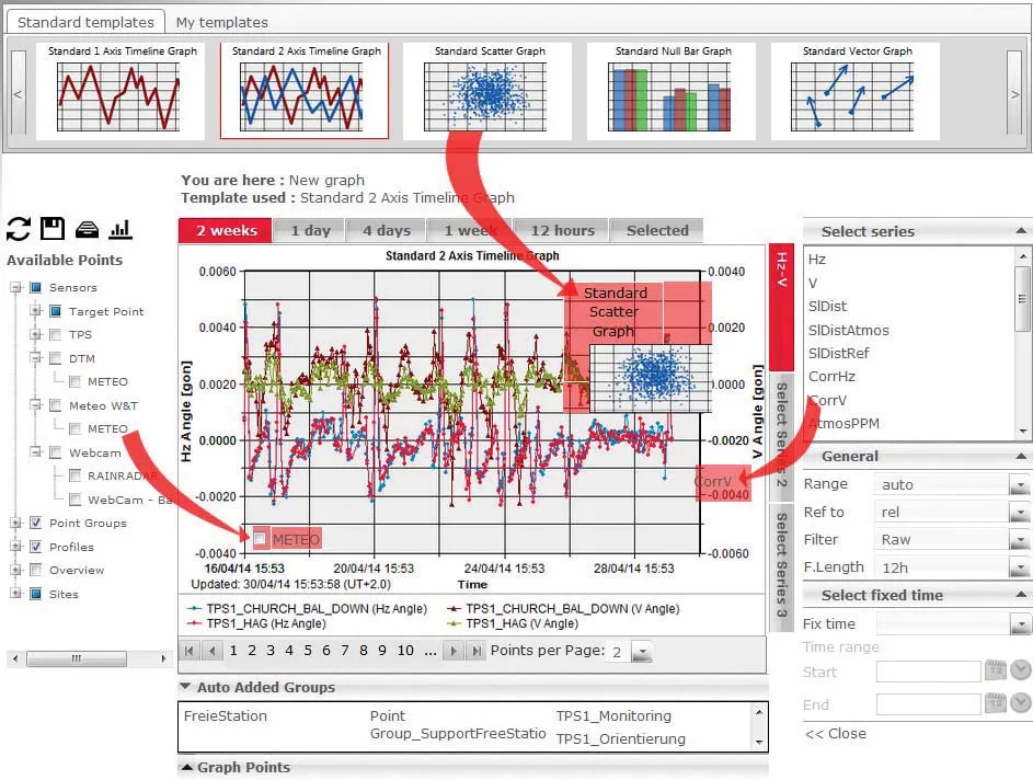
Leica GeoMoS Now! allows users to view and analyse monitoring data from any smart device, such as a computer, tablet or mobile phone. It forms part of a monitoring solution that comes with a web-based user interface and allows graphic visualisations to be edited by users who have no knowledge of web programming.
Immediately after a short setup, end users can start receiving automatic reports with data analysis and customised formatting, which help reduce workloads and enable fast and informed response time. The package is said to be a versatile solution that creates and combines multiple, easy-to-understand graphical representations of monitoring data, which can be sent over to various targeted users or end-customers. Users can define who has access to which data and how it is seen.
The software can be integrated on a user’s company intranet server and data can be accessed from different locations within the company using only a web browser without need for additional local software licenses or installations on different computers. Administrators have complete control of the system, can display monitoring data on one easy-to-read and fully adaptable user interface and can keep sensitive data securely inside the company’s network.
All screen views can be integrated into other web pages and customised to fit company branding by modifying and personalising the login page.
With this package, large quantities of geodetic and geotechnical data are said to be easier to handle with simplified workflows using automatic configuration and distribution tools. The package can quickly notify users of any changes in data for faster, more informed responses.
Leica GeoMoS Now! allows users to view and analyse monitoring data from any smart device, such as a computer, tablet or mobile phone. It forms part of a monitoring solution that comes with a web-based user interface and allows graphic visualisations to be edited by users who have no knowledge of web programming.
Immediately after a short setup, end users can start receiving automatic reports with data analysis and customised formatting, which help reduce workloads and enable fast and informed response time. The package is said to be a versatile solution that creates and combines multiple, easy-to-understand graphical representations of monitoring data, which can be sent over to various targeted users or end-customers. Users can define who has access to which data and how it is seen.
The software can be integrated on a user’s company intranet server and data can be accessed from different locations within the company using only a web browser without need for additional local software licenses or installations on different computers. Administrators have complete control of the system, can display monitoring data on one easy-to-read and fully adaptable user interface and can keep sensitive data securely inside the company’s network.
All screen views can be integrated into other web pages and customised to fit company branding by modifying and personalising the login page.