Traffic management software tools

A joint development project between Delcan Corporation and Intelligent Devices Incorporated (IDI) has resulted in the sophisticated Intelligent NETworks product. This is an integrated product that combines the IDI Intelligent Control NTCIP system with the Delcan advanced transportation applications of NETworks. The system can be linked to dynamic message signs (DMS), CCTV and vehicle detector stations (VDS), traffic intersections, as well as environment road weather sensor stations.
March 5, 2012 Read time: 3 mins
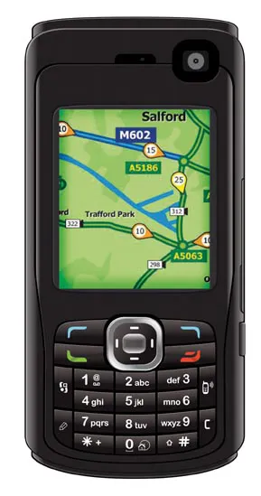
The sophisticated TrafficTV package allows cellphone users access to live traffic information

A joint development project between Delcan Corporation and Intelligent Devices Incorporated (IDI) has resulted in the sophisticated Intelligent NETworks product.

This is an integrated product that combines the IDI Intelligent Control NTCIP system with the 2698 Delcan advanced transportation applications of NETworks. The system can be linked to dynamic message signs (DMS), CCTV and vehicle detector stations (VDS), traffic intersections, as well as environment road weather sensor stations.

Modular platform in design, Intelligent Networks features a range of individual modules that end users can select as required. These include: CCTV, DMS, VDS, highway advisory radio, travel times, data archiving and reporting), urban traffic signals, ramp metering, and automatic vehicle location (AVL).

3658 Buchanan Computing has further developed its proven SignPlot program for designing traffic signs with the launch of its 2.3 version. Customers can use the package for direction signs and parking plates, which are designed individually for each location. It is also used by graphic designers and local authority staff when traffic sign images are needed in reports and consultations and on web sites. The new 2.3 version offers improved graphics using a technique called anti-aliasing, which enables even small thumbnail images of signs to be readable.

The firm's proven ParkMap product is designed for traffic order making and management and the latest version offers a greater range of CAD-like drawing tools, enabling restrictions to be plotted following features on the map. ParkMap version 4.5 also has more options for labelling maps and more functionality specifically for experimental and temporary traffic orders.

The AccsMap is used for recording, checking and analysing road collisions and the improved 4.3 version offers improved querying and accident labelling for greater flexibility.
Both ParkMap and AccsMap now have the ability to rotate a map through any angle when printing it, to enable the best use to be made of the size of paper available, and they allow the area of map that will be included to be selected on screen.

Specialist firm 3657 mxData has developed a new version of its TrafficTV package, which can provide users with real-time traffic information. This data can be streamed direct to cellphones and is available on virtually any handset across all operators. The application is said to make car travel easier due to key upgrades such as better information on accidents and delays, more CCTV cameras added to the network, better GPS support and advanced graphic options. Using this package, drivers can now get more accurate information about accidents or delays on the road ahead to avoid congestion and plan a better route.

Meanwhile GPS support has been improved in response to the rising number of GPS-enabled phones incorporating TrafficTV. Travellers can now use cell phones to plan their journeys and the advanced graphic options mean a clearer view and sharper colours on the handset.

3314 Peek Traffic's new 1.9 version of IQ Central is an improved and advanced Windows-based traffic management software. The upgraded IQ Central adds full support for Peek's new ATC-1000 and ATC-2000 Advanced Transportation Controllers and more robust system-wide device-by-device pattern monitoring, including current pattern and connection status monitoring in a single convenient display. The package also has support for the LMD-9200 controller, both as an isolated local controller and as a device operating under a Peek M3000 master controller, as well as support for the Traconex 390CJ and 390 J-9 traffic controllers.

For more information on companies in this article

Related Content

  • Innovative traffic information technology used in Vancouver
    April 12, 2012
    As the world descended on Vancouver for the 2010 Winter Olympics, visitors were able to travel around the city with confidence and intelligence thanks to a landmark project by IRF Member, Delcan
  • Innovative traffic information technology used in Vancouver
    February 23, 2012
    As the world descended on Vancouver for the 2010 Winter Olympics, visitors were able to travel around the city with confidence and intelligence thanks to a landmark project by IRF Member, Delcan
  • Construction software boosts operating efficiency
    March 5, 2012
    Intelligent data handling and management technologies are helping boost operating efficiency - Mike Woof reports The construction software sector and GIS market are seeing a rapid development of new products and technologies that will help boost efficiency, with factors such as data management and platform integration being key focus areas.
  • Latest GIS and software tools improve operations
    February 24, 2012
    Innovative GIS and software solutions are coming to market from the three key market players - Mike Woof reports Competition is strong in the field for GIS and surveying systems as well as the associated software. The three major players in the sector, Leica Geosystems, Topcon and Trimble, all invest heavily in research and development and continue to roll out new solutions for construction customers that will boost the efficiency of surveying as well as overall project implementation.