Get highly detailed 3D point road surface data from Topcon’s new RD-M2 scanner

April 11, 2025 Read time: 1 min
The vehicle-mounted downward-facing RD-M2 from Topcon Positioning Systems delivers precise surface conditions over long and complex roads

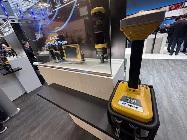
Topcon Positioning System’s new RD-M2 laser scanner has been purpose-built for road resurfacing applications.

The vehicle-mounted downward-facing RD-M2 delivers precise surface conditions over long and complex roads, which means no road closures are needed.  

Millions of points are collected by the vehicle operator from safety of his or her cab.

The 3D point data from the RD-M2 scanner serves as the basis for detailed road surface designs using the Topcon Office Suite.  

These ground-truth surfaces are a part of the company’s SmoothRide system workflow.

Users can take advantage of Topcon’s intuitive workflow to create their own custom design from the scan or they can integrate a predefined template.  

Users can also align the scan to the local coordinate system with millimetre-level precision, providing complete flexibility for road resurfacing projects.  

For more information on companies in this article

Related Content

  • Topcon targets concrete business
    March 10, 2017
    ‘The Intersection of Infrastructure and Technology’ is Topcon’s theme at this year’s CONEXPO-CON/AGG. Topcon sees itself at the conceptual crossroads that provides construction, surveying and engineering professionals with the advantages and know-how to be at the forefront of technological innovation, increasing productivity and profitability for growing infrastructure needs. Industry professionals are continually challenged to cut costs and produce results more quickly.
  • Sandvik’s DT1131i jumbo and iSURE software in Iceland and Norway
    August 14, 2019
    Sandvik’s DT1131i three-boom, electro-hydraulic jumbo, iSURE tunnel management software and the latest drill bit hardware were recently put to the test in Iceland and Norway* Czech contractor Metrostav recently achieved 105m of tunnel excavation in a record-breaking six days. But it will be consistent performance and progress that will see Iceland’s Dyrafjordurgong Tunnel in the remote Westfjords region open on time and on budget. The 5.3km Dyrafjordurgong Tunnel is costing around €69 million and due
  • Leica Cyclone teams up with NCTech’s iSTAR camera database
    January 19, 2016
    Users of Leica Cyclone, a 3D point cloud processing software, can now automatically import and align high-dynamic range (HDR) data from NCTech’s iSTAR camera database. The result is enhanced images delivered faster and easier, according to both companies. “It is also the accuracy to which these images fit the 3D point cloud data that is paramount. NCTech’s iSTAR camera produces high-quality HDR imaging at the accuracy everyone expects,” said Faheem Khan, vice president, business development for Leica Geosys
  • Bentley’s OpenRoads Designer CONNECT Edition Advances Roadway Projects
    November 15, 2016
    OpenRoads’ Comprehensive Modeling Environment Leverages BIM Advancements to Empower Project Delivery LONDON – The Year in Infrastructure 2016 Conference – 1 November 2016 – Bentley Systems, Incorporated, a leading global provider of comprehensive software solutions for advancing infrastructure, today announced that OpenRoads Designer CONNECT Edition will be available for Early Access on December 1, 2016.