Get highly detailed 3D point road surface data from Topcon’s new RD-M2 scanner

April 11, 2025 Read time: 1 min
The vehicle-mounted downward-facing RD-M2 from Topcon Positioning Systems delivers precise surface conditions over long and complex roads

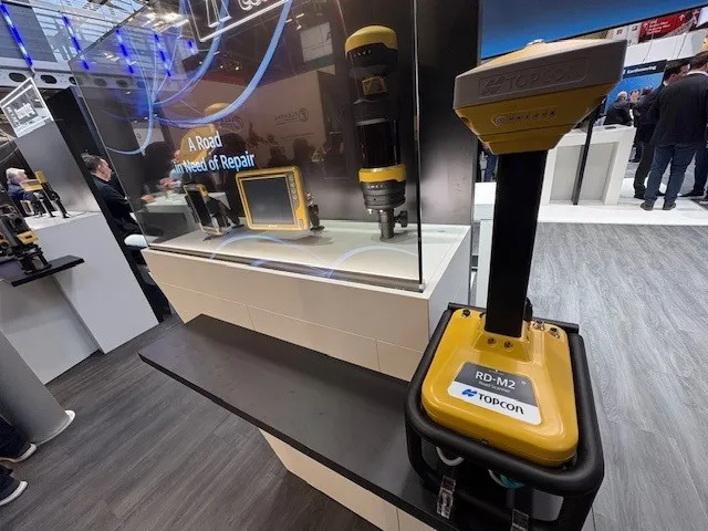
Topcon Positioning System’s new RD-M2 laser scanner has been purpose-built for road resurfacing applications.

The vehicle-mounted downward-facing RD-M2 delivers precise surface conditions over long and complex roads, which means no road closures are needed.  

Millions of points are collected by the vehicle operator from safety of his or her cab.

The 3D point data from the RD-M2 scanner serves as the basis for detailed road surface designs using the Topcon Office Suite.  

These ground-truth surfaces are a part of the company’s SmoothRide system workflow.

Users can take advantage of Topcon’s intuitive workflow to create their own custom design from the scan or they can integrate a predefined template.  

Users can also align the scan to the local coordinate system with millimetre-level precision, providing complete flexibility for road resurfacing projects.  

For more information on companies in this article

Related Content

  • Keysoft Solutions buys LANDCADD rights from Eagle Point
    August 17, 2015
    Landscape and traffic software developer Keysoft Solutions has acquired the rights to LANDCADD software from US-based Eagle Point Software. Jeremy Ellis, managing director of Keysoft Solutions, said both the KeySCAPE and LANDCADD suite of landscape and civil design software will continue as separate products for time being. During a three-month plan, LANDCADD customers will continue to receive technical support from Eagle Point, while Keysoft Solutions builds up a sales and support team in Boston.
  • The road to Ouagadougu in Burkina Faso
    November 12, 2021
    Topcon technology has helped improve the link between Burkina Faso’s capital, Ouagadougu, and six neighbouring countries
  • High performance from Topcon’s HiPer XR
    April 11, 2025

    The HiPer XR, from Topcon Positioning Systems, is a robust high-precision GNSS receiver for surveying, construction and geospatial work. It delivers precision and efficiency, tackling all challenges with RTK accuracy and Dynamic TILT Compensation technology for effortless measurements, even in difficult conditions.

    Its anti-jamming capabilities ensure reliable performance, while the lightweight, rugged design withstands harsh environments. The HiPer XR is about versatile connectivity with long battery life at an affordable price.

  • Road surfacing: the case for sustainability
    March 5, 2020
    Erik Denneman* makes the social and business case for sustainable pavements for which much of the technology already exists.