
Northscan and Bridgology form Nordic alliance

The two companies will together offer their road and bridge scanning and data analysis services in Sweden, Finland and Norway.
By David Arminas April 29, 2024 Read time: 2 mins
Northscan, based in Stockholm and Gothenburg, focuses on non-destructive concrete testing using ground-penetrating radar, ultrasonic pulse velocity and magnetic induction (image courtesy Northscan)

Northscan and Bridgology Sweden say they have formed an “alliance” to offer more accurate non-destructive scanning solutions for bridge inspections and renovations.

Together they will work to provide new opportunities for customers in the Nordic countries of Sweden, Finland and Norway with their expanded analysis process.

Bridgology Sweden’s parent company Bridgology, based in Épalinges, Switzerland, develops software for the analysis and presentation of ground penetrating radar (GPR) data for concrete repair planning and more accurate cost estimates. Particularly prominent is the software for analysis of data from concrete scanning of roadways on road bridges, where it can present data in the form of detailed, graphic and self-explanatory maps adapted for each specific bridge.

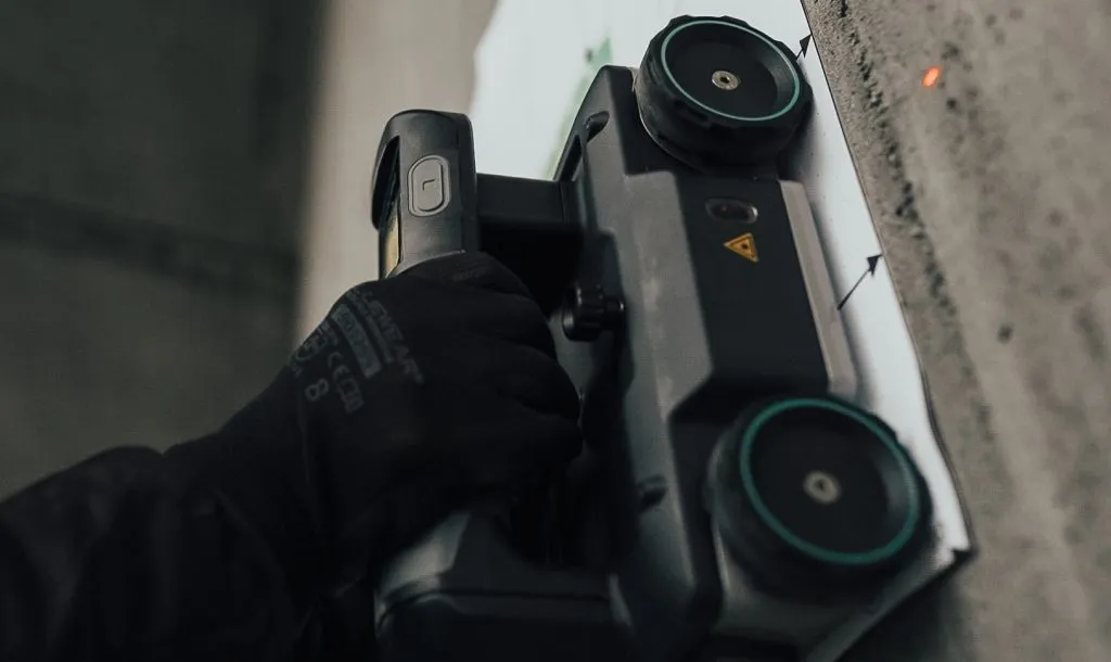
Meanwhile, Northscan, based in Stockholm and Gothenburg, focuses on non-destructive concrete testing using three types of scanning techniques – GPR, UPV (ultrasonic pulse velocity) and magnetic induction (Eddy current technology).

The Swedish Transport Administration alone is responsible for the management of approximately 17,000 bridges in Sweden, with annual operating and maintenance costs exceeding €861.4 million. The companies said that in order to meet this challenge and streamline the use of resources, careful investigation and preparation, repair efforts on bridge decks can be calculated in detail. This will  create the conditions for significant cost savings and better planned repair efforts.

"This partnership truly marks a new era for bridge renovation in the Nordics,” said Jamshid Lodhi, chief marketing officer at Northscan. “By combining our expertise with Bridgology's advanced technology and analysis process, we will be able to offer cutting-edge solutions that benefit both society and the infrastructure sector."

For more information on companies in this article

Related Content

  • An array of innovative software and GIS solutions will boost construction efficiency
    July 18, 2012
    New software and GIS innovations will help boost construction efficiency - Mike Woof reports Major software suppliers continue to develop their technology and offer new products to the market. Major developments from leading firms will help improve operations for contractors in many segments of the construction industry, from initial design and planning through to maintenance. Version 8 of the well-known ARCADY program for assessment of roundabout capacity is just released by UK transport research and soft
  • LiDAR surveying is making inroads into asset management
    December 18, 2017
    In the coming age of the autonomous vehicle, fast and accurate LiDAR surveying will be increasingly important, explains Valdis Vanags. The game-changing introduction of autonomous vehicles relies not only on intelligent traffic systems but well maintained roads to help computer-guided systems navigate using road markings. Laser scanning technology, too, is a game changer when it comes to planning and executing many civil engineering projects, including transport network upgrades and smart city initiatives.
  • Edeva makes Actibump available globally
    May 13, 2022
    Actibump lowers down into the road surface to create a speed bump only when speeding vehicles approach it.
  • Innovative GIS advances from Bluesky
    July 18, 2012
    Aerial survey specialist Bluesky is funding research into the development and use of a new system to map the UK’s cities and towns at night. Bluesky has teamed up with the University of Leicester to look at solutions using new high sensitivity camera sensor technology. Mounted on survey aircraft, the new system can record the location of street lights, illuminated road signs and other night-time sources of light. This can deliver an accurate resource for asset inventories, light pollution assessment and ene