Easy does it with GSSI’s PaveScan RDM 2.0

GSSI says that its PaveScan RDM 2.0, a non-destructive asphalt density assessment tool, is characterised by being easy to use, no matter what technical level the operator has.
By David Arminas February 27, 2023 Read time: 2 mins
By uncovering inconsistencies that occur during the paving process, including poor uniformity and significant variations in density, PaveScan RDM 2.0 helps to avoid premature failures

GSSI, a manufacturer of ground penetrating radar (GPR) equipment, says that from technician to engineer, the PaveScan RDM 2.0 testing system is easy to operate.

The PaveScan RDM 2.0 is a second-generation asphalt density assessment tool ideal for non-destructive asphalt compaction testing, quality assurance/quality control of new pavements and determining pavement non-conformity.

By uncovering inconsistencies that occur during the paving process, including poor uniformity and significant variations in density, PaveScan RDM 2.0 helps to avoid premature failures like road raveling, cracking, and deterioration along joints.

Thanks to seamless GPS integration, real-time onscreen data output and export options, this system is ideal for government transportation agencies and paving contractors alike. The pavement density measurement technology used in PaveScan RDM 2.0 is an accepted American Association of State and Highway Transportation Officials (AASHTO) specification, PP 98-19.

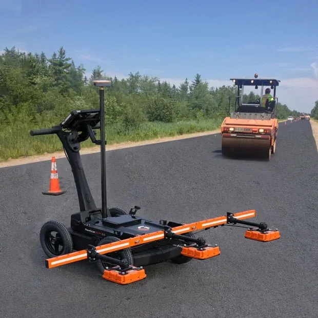
The complete PaveScan RDM 2.0 system includes a rugged deployment cart and an integrated concentrator box that accommodates up to three sensors. It includes housing for cable management and hot-swappable, dual batteries.

The new sensor design was built specifically for the extremes of the asphalt paving environment and features a green laser to aid location accuracy. Also available is a system upgrade kit to expand to three sensors for better pavement coverage.

Additional GPS options and mounting pole provide high precision location information and work seamlessly with the PaveScan interface.

For more information on companies in this article

Related Content

  • Using radar to deliver a fine runway finish
    April 4, 2014
    Radar Portal Systems (RPS) has spent a lot of time developing its sophisticated pavement top-surface photometric imaging system so it can cater specifically for the aviation market. This has now been specially developed for use on aircraft runways and taxiways The system was recently used at Brisbane Airport to survey runway and runway shoulders, collecting photometric top-surface data at a 4m width at speeds of up to 100km/h. This dataset allows the firm to display meshing data of the runway surface showin
  • Road and runway repair success
    July 2, 2012
    Fugro Aperio says it is improving the quality of road and airport runway repair techniques using its sophisticated ground penetrating radar (GPR) technology. The firm is now able to offer a combination of real time kinematic (RTK) GPS with multi channel radar systems due to partnerships with Yotta in the UK, and Pavement Management Services in Australia and the Middle East. This sophisticated package enables pre-planning of surveys, quicker execution and better positioning for more precise mapping of defect
  • Millimetre accuracy for concrete paving
    July 30, 2019
    Concrete paving is now benefiting from the use of sophisticated machine control tools to deliver accuracy and high-quality surfaces Heavy use of concrete roads and runways over time will reveal any flaws in workmanship, the invasion of water, or the wear from use. Discolouration, scaling, crazing, cracking, or curling will sometimes occur due to a poor ready-mix batch, inadequate curing procedure, subgrade settlement, or improper bonding of the finish layer. Concrete surfaces are generally very durab
  • Optimising paving processes with Topcon
    November 21, 2019
    The use of sophisticated machine control technology is integral to delivering high quality and productivity for concrete paving operations