Ver-Mac launches the cloud-based WZMC-1000 work zone camera system

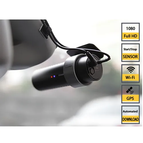
Ver-Mac has launched the WZMC-1000, a fully-automated cloud-based work zone camera system. It comes with an integrated GPS, as well as integrated wifi, a proximity sensor to start-stop recording and voice feedback. The Canadian company, based in Quebec City, says that the easy-to-use low-cost high-definition system allows contractors and agencies a tool to document their projects with very minimal management. It provides high-quality videos along with automatic video transfer and cloud-based storage.
May 18, 2018 Read time: 2 mins
No escaping Ver-Mac’s WZMC-1000, a fully-automated work zone camera system.
Ver-Mac has launched the WZMC-1000, a fully-automated cloud-based work zone camera system.


It comes with an integrated GPS, as well as integrated wifi, a proximity sensor to start-stop recording and voice feedback.

The Canadian company, based in Quebec City, says that the easy-to-use low-cost high-definition system allows contractors and agencies a tool to document their projects with very minimal management. It provides high-quality videos along with automatic video transfer and cloud-based storage.

Ver-Mac says that the WZMC-1000 system can help protect a company against litigation by ensuring accurate daily, weekly and monthly counts of deployed equipment. It also helps documentation of completed activities and can be used as an asset management tool to document quality and condition of a variety of assets.

Ver-Mac says that the system provides documentation that projects are set up correctly, device counts are accurate and a history of completed activities with a record of dates and time.

The camera is mounted on the windscreen of a car. Recording is started simply by putting a hand in front of the lens. After driving through a work zone, simply put a hand again in front of the camera to stop recording.

The system allows users to view the image of the video and the GPS position at the same time. Videos can also be downloaded for future quick reference.

Arriving back at the office, the videos will, with the wifi connection, be automatically downloaded to the cloud.

Related Content

  • Improved laser scanning capabilities
    February 23, 2012
    Leica Geosystems is broadening its software offering with its new Leica Cyclone v7.2 package, which is said to improve office processing capabilities. The package has been developed to address key market needs and trends in the processing and use of rich, as-built point cloud data from high definition laser scanning technology. According to the firm the package can help reduce laser scanning project costs, including office time, allowing projects to use more scans and higher scan densities.
  • Versilis and Haas to offer Safety Cloud alerts
    May 4, 2021
    Versilis safety gates are now integrated with Haas Alert’s Safety Cloud, a cellular-V2X (C-V2X) solution that sends real-time digital alerts to drivers approaching work zones.
  • New Weigh in Motion solutions unveiled to customers at Intertraffic 2014 Amsterdam
    October 1, 2014
    Exciting weigh in motion solutions have been introduced, while a leading North American WIM firm has secured a lucrative US contract. Guy Woodford reports Globally renowned Swiss WIM solution manufacturer Kistler recently launched its new Lineas WIM Data Logger. The data logger has been developed specifically to interface Lineas WIM sensors and to provide the most accurate vehicle weight data. It can be easily integrated into any overall solution by a system integrator to optimally cover several applica
  • Using radar to deliver a fine runway finish
    April 4, 2014
    Radar Portal Systems (RPS) has spent a lot of time developing its sophisticated pavement top-surface photometric imaging system so it can cater specifically for the aviation market. This has now been specially developed for use on aircraft runways and taxiways The system was recently used at Brisbane Airport to survey runway and runway shoulders, collecting photometric top-surface data at a 4m width at speeds of up to 100km/h. This dataset allows the firm to display meshing data of the runway surface showin