Smarter transport solutions from TomTom

TomTom is introducing two novel products that help deliver smart traffic solutions, RoadDNA and its HAD map. The Road DNA will help make automated driving a reality, according to the firm. Designed with vehicle data storage and processing limitations in mind, RoadDNA delivers highly accurate location information that can easily be integrated into the onboard system of a vehicle. This allows a vehicle to continuously know exactly where it is located on the road. It offers highly accurate vehicle localisa
January 4, 2016 Read time: 2 mins
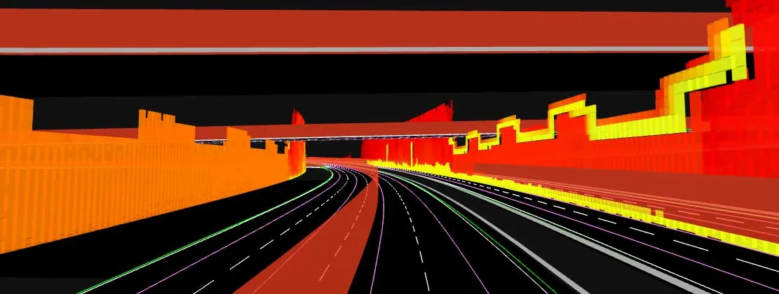
The TomTom technology provides a stepping stone for autonomous vehicle mdevelopment
3972 TomTom is introducing two novel products that help deliver smart traffic solutions, RoadDNA and its HAD map. The Road DNA will help make automated driving a reality, according to the firm. Designed with vehicle data storage and processing limitations in mind, RoadDNA delivers highly accurate location information that can easily be integrated into the onboard system of a vehicle.

This allows a vehicle to continuously know exactly where it is located on the road. It offers highly accurate vehicle localisation content in an efficient and cost-effective way. By matching RoadDNA data with vehicle sensor data in real-time, a vehicle knows its location on the road and even while travelling at high speeds or when changes occur to the roadside. But by converting a 3D point cloud of roadside patterns into a compressed, 2D view of the roadway, RoadDNA delivers a solution that needs little storage space and requires conventional processing requirements, without losing detail.

TomTom RoadDNA, combined with the TomTom HAD Map, delivers real-time information about a vehicle’s precise location on a map whilst coping with changes in the environment. The firm is also offering its HAD Map for Germany. This complete map of Germany covers the entire Autobahn network and provides a 3D lane map for 24,000km of roads.

The TomTom HAD Map for Germany provides accurate representation of 3D geometries of lane centrelines, lane dividers, road borders, and guard rails, as well as highlighting lane-dependent speed limits and lane divider marking types. In addition to enabling future self-driving cars to see beyond their sensors, the TomTom HAD map can also be used for advanced driving applications like improved versions of eco-adaptive cruise control (ACC), lane level guidance, and predictive powertrain control.

For more information on companies in this article

Related Content

  • Moving the earth with improved environmental credentials
    August 9, 2018
    Driver comfort, more power and improved environmental credentials highlight some of the latest earthmoving equipment Doosan Construction Equipment has launched a new version of the company’s DA30 30tonne class articulated dump truck (ADT), now in a new colour scheme. Most of the changes are for better operator comfort and controllability of the machine. But there are also changes in the driveline and electrical systems. The most important development is an upgrade of the suspension to a hydro-gas self-lev
  • The era of workzone data
    July 4, 2018
    Portable work zone messaging is now integral - not an add-on - when it comes to safety on large-scale highway projects. Andrew Williams* reports. Portable work zone ITS solutions have emerged in recent years as important flexible tools for managing major roadwork projects, from new-build to upgrades. They effectively ensure traffic disruption is kept to a minimum and lives can be saved. As such, the technology forms a central component of a major €1.7 billion project in the southern English county of Cambr
  • Wirtgen F-Series Compact Milling Machines for Cost Efficient and Sustainable Cold Milling
    August 1, 2022
    The W 100 Fi Spearheads the New Machine Generation at Bauma 2022
  • Machine control as a key component of digital construction
    November 22, 2017
    By means of digitalisation and modern communication technologies, building information modelling (BIM) techniques are helping to improve construction site planning, process control and operation flow on jobsites.