Intercomp says that its HH400 Handheld Indicator offers additional capabilities over the previous TL-RFX Indicator.
This now offers added features such as output to RFX enabled wireless printers, memory storage, and RS232 output. The unit can be used for monitoring and controlling CS and TL Series Crane and Tension Link Scales, as well as PT and LP Portable Wheel Load Scales from up to 90m away. With three display modes, it allows simultaneous viewing of data from up to four scales from a large, graphic
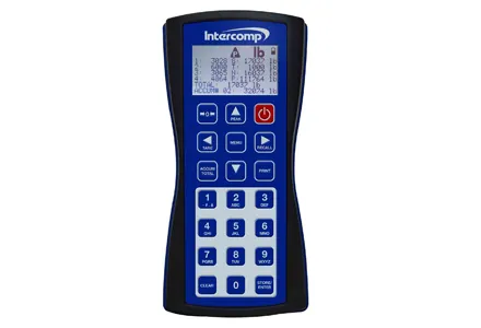
This now offers added features such as output to RFX enabled wireless printers, memory storage, and RS232 output. The unit can be used for monitoring and controlling CS and TL Series Crane and Tension Link Scales, as well as PT and LP Portable Wheel Load Scales from up to 90m away. With three display modes, it allows simultaneous viewing of data from up to four scales from a large, graphic display in an IP65 ergonomically designed housing. These state-of-the-industry features make this NTEP certified indicator an ideal solution for any weighing application requiring remote monitoring and control of up to four scales.
The firm has also upgraded its Handheld Weighing Indicator, fitting it with added capabilities.
Now called the HH60 Handheld Indicator this proven indicator can monitor up to six scales, and benefits from increased memory storage with a RS232 port for data transfer. The unit can be used to control scale functions remotely, and is NTEP certified providing users a choice between handheld wireless indicators. Other wireless indicator options available from Intercomp include IntercompWeigh Software, PT20 self-enclosed CPU, and apps to control and monitor scales from iPhone, iPod and iPad.