Exodigo digs deep in Tel Aviv

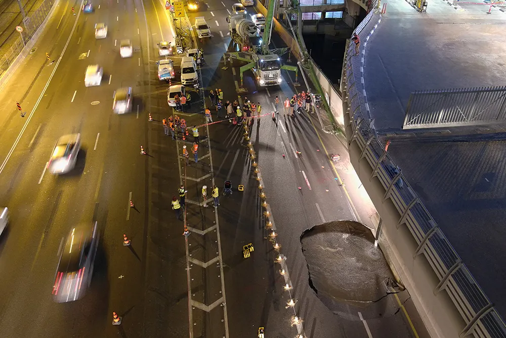
When a large sinkhole opened up on a busy highway in Tel Aviv, Israel, city transport authorities called in the underground mapping experts from Exodigo.
January 31, 2023 Read time: 2 mins
Exodigo uses sensors and cloud-based AI to produce accurate 3D maps of underground areas as deep as 10m (image courtesy Exodigo)

Exodigo’s AI/3D underground mapping tech assessed both current and future risks while the highway was shut down in that area. Exodigo's platform was used not only to assess what could safely open/resume operation, but to provide immediate corrective actions in areas suspected of being unstable to minimise the risk of sinkhole expansion.

The company says that its platform can detect any buried object, from man-made pipes and cables to soil layers, rocks, minerals, and even groundwater. It also works at any scale and terrain, from crowded urban environments to vast rural ones.

Using its advanced, non-intrusive underground mapping AI platform, Exodigo immediately scanned the area with multiple sensor types. The team quickly identified potential risks in surrounding areas on the highway and confirmed the integrity of the areas supporting train infrastructure through its multi-sensing AI platform.

Giving crews the ability to have an accurate, combined CT/MRI/X-ray scan of what is underground can help minimise risks in a wide range of both everyday construction/infrastructure activities and potentially fatal situations such as sinkholes.

According to Exodigo, no other technologies properly “see” underground. Meanwhile, the company’s technology rapidly creates digital, 3D geographic maps of the underground – utilities, pipes and cables, as well as details on soil layers, rocks, minerals and groundwater.

For more information on companies in this article

Related Content

  • Smart system for recording road repairs
    May 25, 2016
    The new Site-Track system is said to offer a sophisticated tool for tracking road repairs. The system can be used for identifying new installation or repairs for utilities and recording all utilities in the immediate area of the installation. The package offers a method of relocating previously recorded information rapidly, without the need for advanced skills or technologies such as GPS and is said to be invaluable for night-time or emergency works. The package can provide accurate location of critica
  • Nottingham study of smart scanning detects early pothole signs
    May 11, 2015
    Researchers at Nottingham Trent University in the UK are developing smart scanning technology using existing cameras to detect early signs of pothole development The technology scans roads for ravelling - the loss of aggregates from the asphalt which leads to potholes and cracks. Combined with 2D and 3D scanners on a pavement monitoring vehicle, a computer vision algorithm can examine the road with accuracy at traffic speed during day or night. The system works by detecting different textures of th
  • Bentley Systems launches OpenRoads Designer CONNECT Edition
    April 13, 2017
    The beginning of this year saw Bentley Systems launch a major advanced comprehensive global tool for today’s increasingly widespread BIM environment. Christmas 2016 came early for Bentley's global clients. In fact, they had a hint of what was going to be under their tree come the celebrations in December. On November 1, at Bentley’s annual global client gathering and awards event Year in Infrastructure Conference in London, the solutions provider announced that OpenRoads Designer CONNECT Edition would be a
  • Trial of innovative real-time alerts for wildlife on highways
    May 2, 2012
    The Colorado Department of Transportation (CDOT) is testing a first-in-the-USA detection system that alerts drivers in real time of wildlife on highways that cause risk to motorists. The OmniTrax solution from Senstar is based on a volumetric electromagnetic proven sensor, buried approximately one third of a metre underground and about 10 metres from either side of the roadway.