
Exodigo digs deep in Tel Aviv

When a large sinkhole opened up on a busy highway in Tel Aviv, Israel, city transport authorities called in the underground mapping experts from Exodigo.
January 31, 2023 Read time: 2 mins
Exodigo uses sensors and cloud-based AI to produce accurate 3D maps of underground areas as deep as 10m (image courtesy Exodigo)

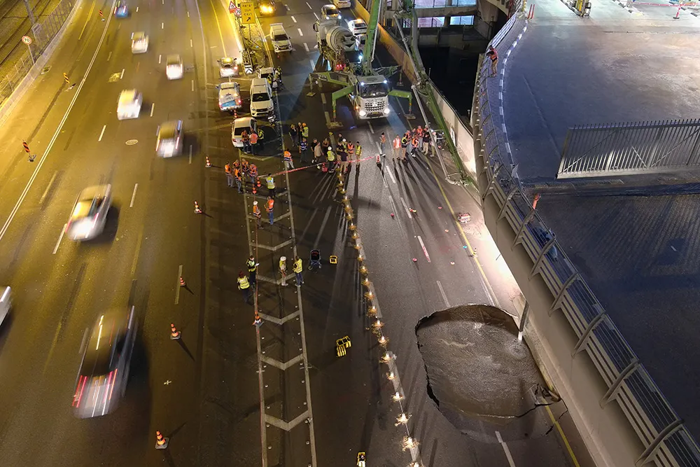
Exodigo’s AI/3D underground mapping tech assessed both current and future risks while the highway was shut down in that area. Exodigo's platform was used not only to assess what could safely open/resume operation, but to provide immediate corrective actions in areas suspected of being unstable to minimise the risk of sinkhole expansion.

The company says that its platform can detect any buried object, from man-made pipes and cables to soil layers, rocks, minerals, and even groundwater. It also works at any scale and terrain, from crowded urban environments to vast rural ones.

Using its advanced, non-intrusive underground mapping AI platform, Exodigo immediately scanned the area with multiple sensor types. The team quickly identified potential risks in surrounding areas on the highway and confirmed the integrity of the areas supporting train infrastructure through its multi-sensing AI platform.

Giving crews the ability to have an accurate, combined CT/MRI/X-ray scan of what is underground can help minimise risks in a wide range of both everyday construction/infrastructure activities and potentially fatal situations such as sinkholes.

According to Exodigo, no other technologies properly “see” underground. Meanwhile, the company’s technology rapidly creates digital, 3D geographic maps of the underground – utilities, pipes and cables, as well as details on soil layers, rocks, minerals and groundwater.

For more information on companies in this article

Related Content

  • Plantworx 2013 focus on latest safety technology for worksite vehicles
    November 28, 2012
    Plantworx 2013 will showcase the latest worksite vehicle safety systems. GKD Technik’s (GKD) Incline Alert system will be among those featured at the UK’s largest construction show, spanning 100,000m², being held at Stoneleigh Park, Coventry Warwickshire on 16 May, 2013. The system is said by GKD to have been developed to meet a need for incline monitoring in the construction and utility maintenance industries, particularly for smaller excavators, which carry a higher risk of overturning when operating on i
  • Digitising roadwork in civil construction with Liebherr
    May 30, 2025
    The construction industry is undergoing significant transformation, driven by rising fuel prices, economic pressure, work safety and lack of qualified operators.
  • Bentley Systems partners with Google
    October 10, 2024
    Bentley Systems is partnering with Google to deliver more efficient use of data.
  • Revolutionary cable locator
    June 19, 2012
    Leica Geosystems says its new Leica Digicat 600i and 650i series, with Logicat software, is set to revolutionise underground cable location. The 600i and 650i, fitted with what Leica says is an innovative data capture and on-board memory function, is said to aid operations management moves to increase onsite safety by detecting cables and identifying operator training needs. Locating underground cables and pipes is said to be a simple and efficient task with the 600i and 650i series, boosting the operator’s