Exodigo digs deep in Tel Aviv

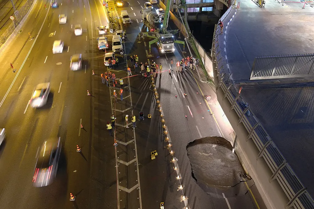
When a large sinkhole opened up on a busy highway in Tel Aviv, Israel, city transport authorities called in the underground mapping experts from Exodigo.
January 31, 2023 Read time: 2 mins
Exodigo uses sensors and cloud-based AI to produce accurate 3D maps of underground areas as deep as 10m (image courtesy Exodigo)

Exodigo’s AI/3D underground mapping tech assessed both current and future risks while the highway was shut down in that area. Exodigo's platform was used not only to assess what could safely open/resume operation, but to provide immediate corrective actions in areas suspected of being unstable to minimise the risk of sinkhole expansion.

The company says that its platform can detect any buried object, from man-made pipes and cables to soil layers, rocks, minerals, and even groundwater. It also works at any scale and terrain, from crowded urban environments to vast rural ones.

Using its advanced, non-intrusive underground mapping AI platform, Exodigo immediately scanned the area with multiple sensor types. The team quickly identified potential risks in surrounding areas on the highway and confirmed the integrity of the areas supporting train infrastructure through its multi-sensing AI platform.

Giving crews the ability to have an accurate, combined CT/MRI/X-ray scan of what is underground can help minimise risks in a wide range of both everyday construction/infrastructure activities and potentially fatal situations such as sinkholes.

According to Exodigo, no other technologies properly “see” underground. Meanwhile, the company’s technology rapidly creates digital, 3D geographic maps of the underground – utilities, pipes and cables, as well as details on soil layers, rocks, minerals and groundwater.

For more information on companies in this article

Related Content

  • Smart road test facility in Virginia
    July 28, 2015
    A test stretch of road in the US is playing a valuable role in developing technology and boosting traffic safety -*Tom Gibson writes Located a short distance from the Virginia Tech campus in the mountains of rural southwest Virginia in the mid-Atlantic region of United States, the Virginia Smart Road looks like a conventional road. But venturing to either end of the 3.5km-long thoroughfare reveals that it actually goes nowhere, at least for now. The result of a plan conceived back in the 1980s, the Vi
  • Innovation in road design and management software
    February 17, 2012
    The emphasis on data processing and re-use, continues to grow in the development of design and management software. The interoperability of software, the need to handle and process larger amounts of data, and re-use and retention of data sets from one task to another have been a growing emphasis in the past few years. It allows infrastructure companies to get better value from expensively collected information and to focus more on the whole life cycle of projects.
  • Focusing on workzone safety systems
    March 16, 2012
    The US has seen a major reduction in deaths following accidents in its highway construction work zones, while Europe and other parts of the world are looking at new safety technology and systems to trigger a similar trend. Guy Woodford reports. Work in the US to reduce the likelihood of potentially fatal accidents at highway work zones is paying dividend.
  • Software tools aid construction, reduce costs
    February 28, 2012
    Integrated construction software offers an effective planning solution - *Mark Nichols writes. In a world where resources are limited, 20 year designing and building in a sustainable way is more critical than ever. By employing today's software tools it is possible to reduce the total cost of construction of a new highway, while reducing operating costs and environmental impacts. The path to achieving the greatest gains is to take a holistic approach to the plan, design, construct and operate process from t