
CityStream goes on stream for US authorities

Nexar’s CityStream platform allows road agencies to see the layout of work zones any time.
By David Arminas September 1, 2021 Read time: 2 mins
Nexar’s CityStream licence allows users to know how many work zones there are at any given time (image courtesy Nexar)

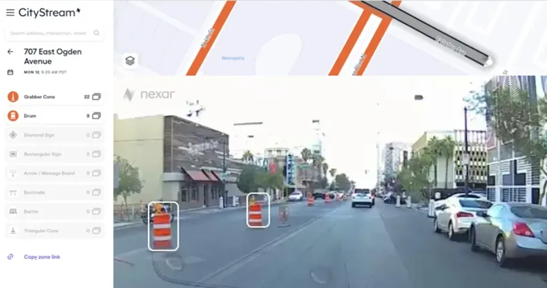
Nexar is to provide free for a limited time to US transit agencies a service that detects, monitors and maps road work zones.

Nexar, based in New York City, produces dash cams and platforms for vehicle-to-vehicle networks that help prevent collisions. To do so, Nexar’s dash cams within the vehicles of drivers using the company’s services collect data every month across around 210 million kilometres (130 million miles) of roads. The company says it has a dataset of 3.2 trillion images, including real-time images of work zones.

The company’s said it is offering its CityStream service free for three months to road agencies and transportation departments because it believes that work zones are generally unreported to mapping services. Nexar said all its images are accurately located for context and time before being sent to city officials.

“As a result of Covid-19, traffic patterns have become even more dynamic, which means valuable time is wasted optimising safety and moderating traffic congestion in work zones,” said Eran Shir, co-founder of Nexar.

Shir said that Nexar enables cities to go back in time and check work zone setups whenever they wish instead of having to use old data or out-of-date plans because work zone areas have changed. This ensures cities and transportation departments are addressing transportation patterns on a real-time basis.

The issue is particularly important because US government plans to rebuild infrastructure, including fixing 320,000km (20,000 miles) of roads and 10,000 bridges, are expected to create a sharp increase in new work zones. This will cause traffic congestion and safety challenges.

More information and how to apply for a licence is available on Nexar’s website by clicking here.

For more information on companies in this article

Related Content

  • Traffic management software tools
    March 5, 2012
    A joint development project between Delcan Corporation and Intelligent Devices Incorporated (IDI) has resulted in the sophisticated Intelligent NETworks product. This is an integrated product that combines the IDI Intelligent Control NTCIP system with the Delcan advanced transportation applications of NETworks. The system can be linked to dynamic message signs (DMS), CCTV and vehicle detector stations (VDS), traffic intersections, as well as environment road weather sensor stations.
  • France to complete cycling network by 2030
    March 28, 2023
    Around 510km were created last year to the national network in an effort to get even hesitant cyclist onto their bicycles as a means of getting to work and also getting out to play, in the city or the countryside.
  • Protecting bridge assets over time
    September 1, 2021
    One of the challenges facing transportation agencies today is how to conduct accurate, timely, and safe bridge inspections. Maintaining bridges is important to ensure public safety, and bridge owners and engineers need to perform regular inspections to determine the structural integrity of bridges so that they can plan for maintenance, rehabilitation, and replacement of those bridges.
  • From managed asset to service provider: the future highway
    May 20, 2019
    Every day we hear about Mobility as a Service (MaaS), but what about Roads as a Service? Geoff Hadwick reports from the ERF in Brussels The familiar physical asset called the road will increasingly be seen as part of an emerging global services sector. Given that, the role of the road is changing, notes Christophe Nicodème, general director of the European Union Road Federation (ERF). We need to think much more carefully about planning highway infrastructure in terms of people’s needs, said Nicodème,