Smart traffic analysis improvements

Transport and traffic analysis nowadays tends to switch between static analysis modelling for large scale studies and microsimulation for finer grain work, with perhaps the mesoscopic model also finding a place for mid-level. Most producers make software tools at all three levels and increasingly package them together. Spanish firm TSS (Transport Simulation Systems) has gone one better with its latest release Aimsum 7, by giving it the capacity to "zoom in" from a larger scale mesoscopic model to a smaller
June 12, 2012 Read time: 2 mins
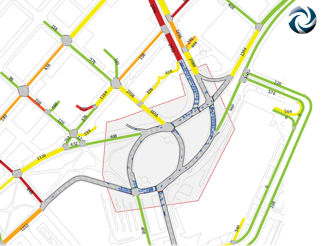
A mesoscopic model of the Aimsun hybrid simulator showing a microscopic pocket of greater detail

Transport and traffic analysis nowadays tends to switch between static analysis modelling for large scale studies and microsimulation for finer grain work, with perhaps the mesoscopic model also finding a place for mid-level. Most producers make software tools at all three levels and increasingly package them together.

Spanish firm TSS (Transport Simulation Systems) has gone one better with its latest release Aimsum 7, by giving it the capacity to "zoom in" from a larger scale mesoscopic model to a smaller area that need microsimulation work, all on the one screen.

It calls the concept the "hybrid simulator" which combines an event-based mesoscopic model with a more detailed time-sliced microsimulation.

This marks a sea change in how traffic models will be conceived, the firm claims, declaring that the method means models will not simply be built once and then discarded. "The hybrid makes it possible for the first time to build demand models on a larger and larger scale using a single all-in-one package,” claimed TSS managing director Jaime Ferrer “with no cumbersome manual interfacing between macroscopic and microscopic models and no need to be updating and revising separate models with independent networks and databases."

154 Aimsun 7 also includes a new network revisions feature, which allows a change made in the base network model to apply automatically to all related future scenarios.

Another new feature is the FZP exporter, which exports simulations to 685 Autodesk 3Ds Max for high–quality 3D presentations. OpenStreetsMap importer allows import of geometry from anywhere via the internet.

For more information on companies in this article

Related Content

  • The use of telematics in construction machines is growing
    May 20, 2015
    Demand for telematics technology is growing, as equipment users begin to lean the value of these systems – Alan Dron reports With construction projects increasingly operating to wafer-thin profit margins, any technological assistance that can keep the accounts in the black is welcome. This is particularly the case with those projects where contractors can share a larger slice of the profits if they complete their work ahead of schedule. The downside, of course, is that they also share the pain if the
  • Eager for efficiency
    February 20, 2012
    Efforts to improve energy efficiency in any quarry will be furthered by a new EU-funded project now underway. Madrid-based consulting firm Solintel is leading a new €6.3million research and development project, which is part funded by the EU, to find new techniques for modelling and applying energy efficiency improvements for every aspect of quarrying.
  • Increased use of reclaimed asphalt, reduced emissions
    February 10, 2012
    Reducing emissions and increasing the use of reclaimed asphalt pavement is among the key aims of plant manufacturers. Patrick Smith reports. Lower emissions and the use of recycled materials coupled with reduced costs are the aims of manufacturers of modern asphalt plants.
  • Topcon announces increased 3D scanning integration with Autodesk
    August 17, 2015
    Topcon Positioning Group says it has improved workflow compatibility for the GLS-2000 3D laser scanner and ScanMaster software with Autodesk solutions. With the latest version of Autodesk ReCap, the GLS-2000 pairs with Topcon ScanMaster software to collect, process, edit and deliver 3D point cloud data from a laser scanner. ReCap allows users to perform tasks such as scan conversion, editing and viewing point cloud data. It also provides integration with Autodesk’s portfolio of design software. Aut