Mapping the asset
High-speed data collection just got faster for England’s newly created strategic roads operator
Highways England’s establishment as a publicly held company in 2015 created a need for a highly accurate asset inventory. This was potentially very costly and had serious safety implications.
As well as its relationships with numerous managing agents and contractors, assets include 35,300km of highway, 12,100km of earthworks, 23,200km of safety fences, 150,000 technology assets and sig
High-speed data collection just got faster for England’s newly created strategic roads operator
8100 Highways England’s establishment as a publicly held company in 2015 created a need for a highly accurate asset inventory. This was potentially very costly and had serious safety implications.
As well as its relationships with numerous managing agents and contractors, assets include 35,300km of highway, 12,100km of earthworks, 23,200km of safety fences, 150,000 technology assets and signs and 33,800km of drainage. It was also known that data held within Highways England’s systems were in places incomplete.
Traditional, manually intensive information-gathering methods require traffic-management measures, typically involving lane closures. These are expensive and time-consuming, not to mention inherently risky for both operatives and road users.
Highways England also has an ongoing programme of rolling out Smart Motorway schemes. These hard-shoulder running schemes make the static collection of geo-referenced data difficult, if not impossible, outside of construction phases. Accurate, geo-referenced data needed to be gathered, retained and easily updated.
It enables highly accurate laser point clouds and imagery of exceptional quality to be collected from a vehicle moving at highway speeds. Once processed, office-based users can extract high-quality inventory data.
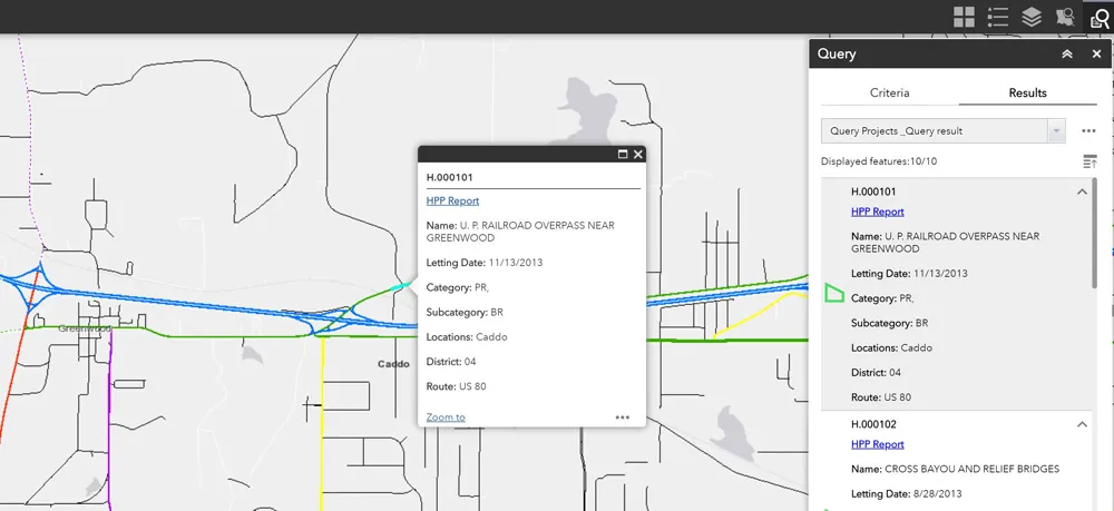
The locations and attributes of the large number of surface-visible assets gathered by the MMS will be used to populate Highways England’s Integrated Asset Management Information System (IAM-IS), a central, national-level repository for asset data and information about associated maintenance activities.
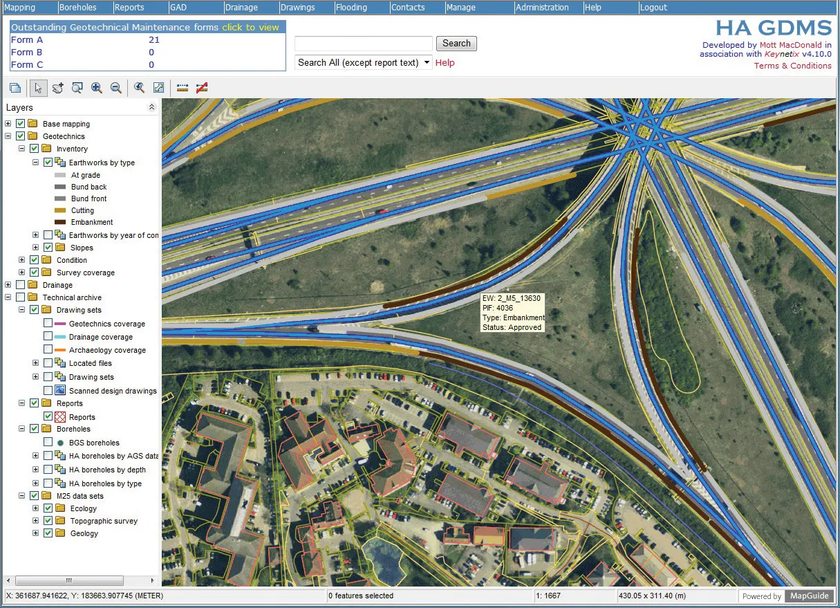
In addition, Highways England’s Asset Visualisation Information System (AVIS) - provided by IBI Group - will enable Highways England and its supply chain to visualise its asset data alongside MMS datasets. This includes imagery and LiDAR, mapping and other datasets.
The RouteMapper Internet-based viewer provides access to an array of imagery and LiDAR point cloud visualisation and measurement functions in a single platform. The viewer uses a web-based mapping engine based on the open-source, Java-based GeoServer environment. Users can share and edit geospatial data. It uses data from any major spatial sources, including open standards such as Web Feature Service and Web Coverage Service, as well as a high-performance certified-compliant Web Map Service (WMS).
To ensure security, all datasets can be hosted on dedicated, secure servers alongside options for double redundancy to maintain access continuity. Any spatial data can be incorporated into the mapping environment. This includes section/chainage, marker post referencing and gazetteers alongside the open-source GeoServer mapping layers - all of which can be navigated to and interrogated in terms of attributes.
LiDAR-only data-gathering takes place at 120kph in Lane 2 from the hours of 10pm to 5am. Although this is done at a speed unlikely to restrict traffic flow, it also takes advantage of times when traffic is light in order to minimise occlusions caused by other vehicles passing the survey vehicle. A third pass is also made on slip roads.
The levels of detail and accuracy achieved are impressive. JPEG images of 5MP resolution and 2m spacing are geo-referenced to <500mm. LiDAR point data is accurate to <30mm, with more than 500 points/m gathered on road surfaces. Inter-point spacing is <100mm on all lanes, including the hard shoulder. Cumulatively, absolute positioning of assets is <30mm or <10mm where scheme ground control is installed.
As part of final delivery, imagery from each of the four cameras is redacted - machine vision technology is used to scan the high numbers of images generated for specific features, such as a vehicle’s number plates and people’s faces, which must be removed or blurred. This is done using IBI Group’s own redaction software, which has been developed to achieve a high rate of image throughput.
The MMS/RouteMapper technology is already well-proven on strategic roads in England. By comparison with having to implement traffic management and manually measure and collate, savings of up to 80% can be achieved.
As well as its relationships with numerous managing agents and contractors, assets include 35,300km of highway, 12,100km of earthworks, 23,200km of safety fences, 150,000 technology assets and signs and 33,800km of drainage. It was also known that data held within Highways England’s systems were in places incomplete.
Traditional, manually intensive information-gathering methods require traffic-management measures, typically involving lane closures. These are expensive and time-consuming, not to mention inherently risky for both operatives and road users.
Highways England also has an ongoing programme of rolling out Smart Motorway schemes. These hard-shoulder running schemes make the static collection of geo-referenced data difficult, if not impossible, outside of construction phases. Accurate, geo-referenced data needed to be gathered, retained and easily updated.
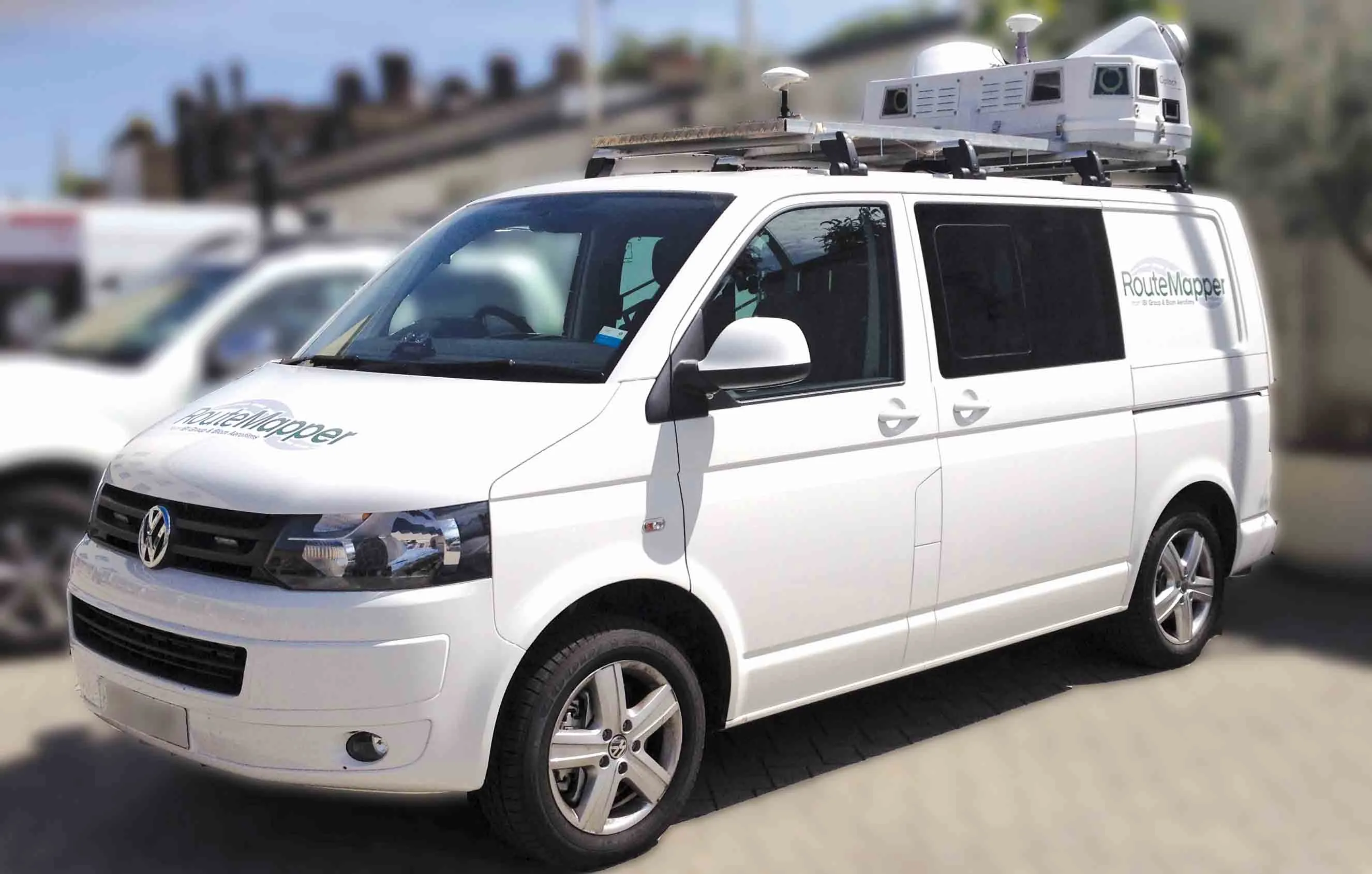
Mobile Mapping System
IBI Group has been supporting Highways England’s Asset Information Group by supplying state-of-the-art data-gathering and hosting services. Imagery equipment originally commercialised by IBI Group in 2006 has been combined with Teledyne Optech’s SG1 LiDAR systems to create a Mobile Mapping System (MMS) – the Routemapper.It enables highly accurate laser point clouds and imagery of exceptional quality to be collected from a vehicle moving at highway speeds. Once processed, office-based users can extract high-quality inventory data.
The locations and attributes of the large number of surface-visible assets gathered by the MMS will be used to populate Highways England’s Integrated Asset Management Information System (IAM-IS), a central, national-level repository for asset data and information about associated maintenance activities.
In addition, Highways England’s Asset Visualisation Information System (AVIS) - provided by IBI Group - will enable Highways England and its supply chain to visualise its asset data alongside MMS datasets. This includes imagery and LiDAR, mapping and other datasets.
RouteMapper
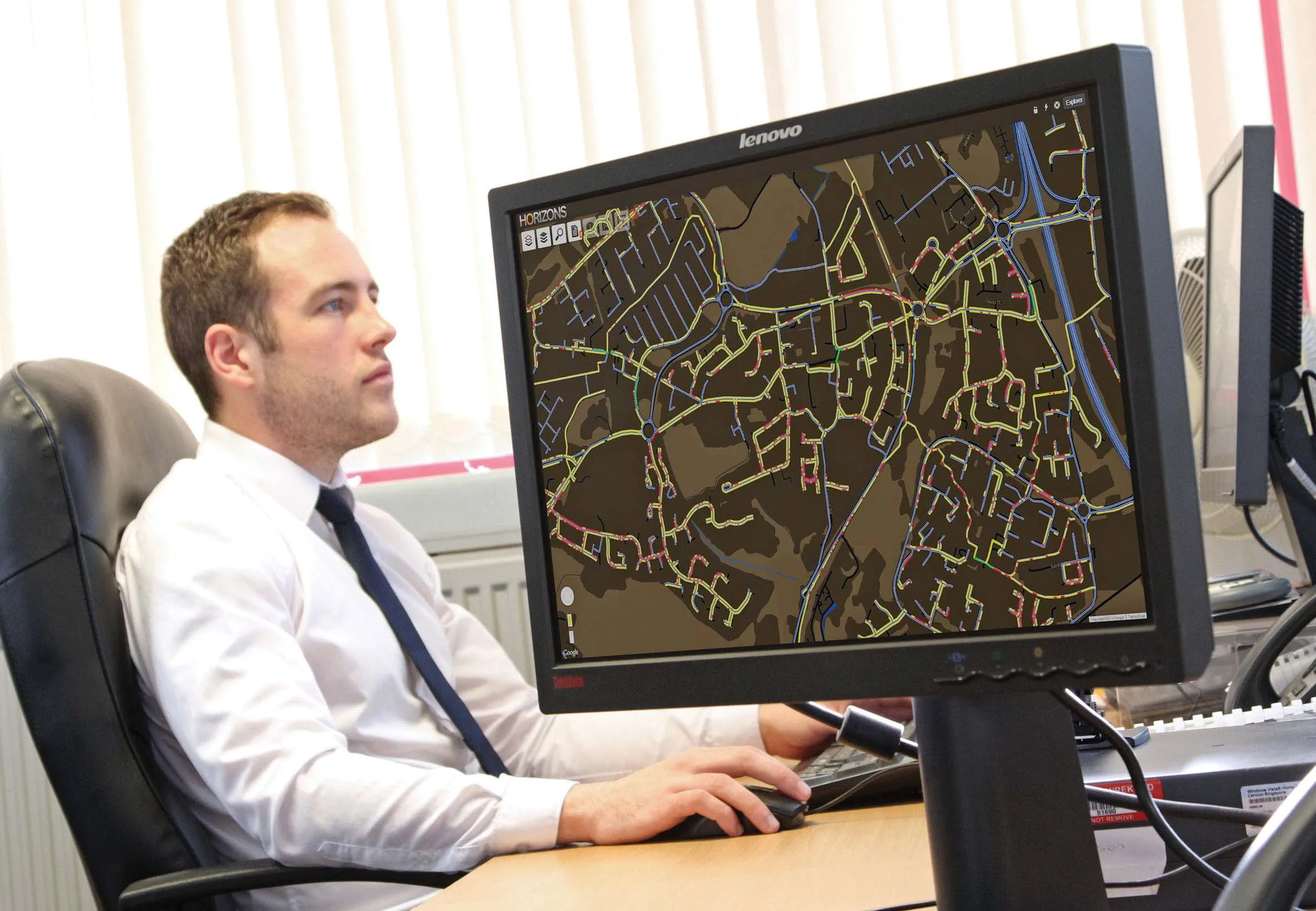
There are several areas in which, daily, organisations can increase efficiencies through accessing their geospatial information in conjunction with imagery and LiDAR point clouds. These include: asset management, drainage, geotechnical, environmental, design, incident management, customer care and enquiries, value management evidence, auditing third parties, and traffic management. RouteMapper as a service, enables customers to gain all of these advantages without making large in-house investments in software, hardware, storage and specialist know-how.The RouteMapper Internet-based viewer provides access to an array of imagery and LiDAR point cloud visualisation and measurement functions in a single platform. The viewer uses a web-based mapping engine based on the open-source, Java-based GeoServer environment. Users can share and edit geospatial data. It uses data from any major spatial sources, including open standards such as Web Feature Service and Web Coverage Service, as well as a high-performance certified-compliant Web Map Service (WMS).
To ensure security, all datasets can be hosted on dedicated, secure servers alongside options for double redundancy to maintain access continuity. Any spatial data can be incorporated into the mapping environment. This includes section/chainage, marker post referencing and gazetteers alongside the open-source GeoServer mapping layers - all of which can be navigated to and interrogated in terms of attributes.
On the road
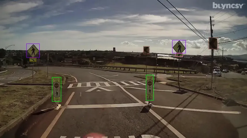
To gather data, a vehicle equipped with multiple cameras and LiDAR sensing technology drives along the road to be surveyed. Multiple passes are made in order to guarantee data quality. A pass is made at 80kph in Lane 1 of a motorway or trunk road and both imagery and LiDAR data are gathered. All passes involving imagery are made in good ambient light conditions, taking account of time of day and weather, such as precipitation.LiDAR-only data-gathering takes place at 120kph in Lane 2 from the hours of 10pm to 5am. Although this is done at a speed unlikely to restrict traffic flow, it also takes advantage of times when traffic is light in order to minimise occlusions caused by other vehicles passing the survey vehicle. A third pass is also made on slip roads.
The levels of detail and accuracy achieved are impressive. JPEG images of 5MP resolution and 2m spacing are geo-referenced to <500mm. LiDAR point data is accurate to <30mm, with more than 500 points/m gathered on road surfaces. Inter-point spacing is <100mm on all lanes, including the hard shoulder. Cumulatively, absolute positioning of assets is <30mm or <10mm where scheme ground control is installed.
As part of final delivery, imagery from each of the four cameras is redacted - machine vision technology is used to scan the high numbers of images generated for specific features, such as a vehicle’s number plates and people’s faces, which must be removed or blurred. This is done using IBI Group’s own redaction software, which has been developed to achieve a high rate of image throughput.
The MMS/RouteMapper technology is already well-proven on strategic roads in England. By comparison with having to implement traffic management and manually measure and collate, savings of up to 80% can be achieved.