
Zehntner unveils new ZRM 6013+ Road Marking Retroreflectometer

Zehntner Testing Instruments was due to launch the ZRM 6013+ portable handheld retroreflectometer for road markings, an optimised reissue of the classic ZRM 6013, at Intertraffic Amsterdam 2014 (25-28 March 2014).
February 25, 2014 Read time: 2 mins
1285 Zehntner Testing Instruments was due to launch the ZRM 6013+ portable Handheld retroreflectometer for road markings, an optimised reissue of the classic ZRM 6013, at Intertraffic Amsterdam 2014, 25-28 March 2014.

Like all the Swiss manufacturer’s products, the new retroreflectometer is fast, easy to use and delivers reliable, precise results for all kinds of road markings.

The main focus has been put on speeding up the measuring process: RL and Qd are measured in about two seconds; single measurements of RL or Qd take only one second each. “Combined with the easy operation, this is a priceless advantage for the user" said a Zehntner spokesperson. "Everyone who has made field measurements knows that speed is of the essence and increases the safety."

The large, well-arranged 5.7 inch colour touch display makes the operation even easier. Intuitive menu guidance has always been a matter of course in Zehntner products.
Optionally the retrometer can be equipped with an extended handle, a built-in thermal printer and a WAAS GPS unit.

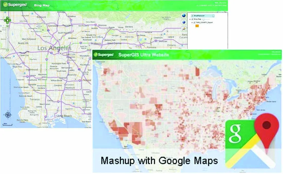
This free versatile mapping and data analysis software ‘MappingTools’ makes administration and analysis of the road marking measurements fast and simple. The retroreflection measurements can be analysed to individual specifications and results can be displayed on a map, for example Bing, or Google Earth. The user can specify colour coded profiles with freely adjustable retroreflection threshold values. This can be displayed on the map accordingly. This is a valuable support in decision-making on maintenance planning to increase / maintain safety and efficiency.

The MappingTools software is provided free of charge with the following instruments: ZRM 6013+ and ZRM 6014 Retroreflectometer for measuring the night and day visibility of road markings, ZDR 6020 Dynamic retroreflectometer RL for continuous measurement of the night visibility of road markings as well as ZRS 6060 Retroreflectometer for measuring the night visibility of traffic signs, safety garments and other reflexive materials.

The ZRM 6013+ ranks between the budget priced entry level retroreflectometer ZRM 6006 and the top class retroreflectometer ZRM 6014.

For more information on companies in this article

Related Content

  • Istanbul opts for RetroTek pavement assessments
    May 9, 2019
    Metropolitan Istanbul’s transportation department has chosen a RetroTek-M Dynamic Road Marking Retroreflector to assist with the pavement assessments. The retroreflectometer was chosen over traditional dynamic side-mounted systems because it is easy to operate, according to the manufacturer, Reflective Measurement Systems, based in Dublin, Ireland. Fitted to the front of the vehicle with good road clearance also makes it a safer solution for the operator or driver and other users. It is twice as effic
  • Transtec and FHWA release Intelligent Compaction Measurement paper
    February 23, 2018
    Intelligent Compaction Measurement Values – ICMV – can be difficult to understand. What’s more, there is a lack of systematic and comprehensive documents explaining ICMV. For these reasons, the Federal Highway Administration (FHWA) and pavement engineering firm Transtec Group have released a technical brief to demystify ICMV. ICMV is a generic term for advanced measurement systems instrumented on vibratory rollers as a key components of intelligent compaction (IC) systems. It is based on the acceleration
  • Supergeo offers GIS training tool
    April 27, 2015
    Supergeo Technologies says that its latest packages offer effective training for both GIS users and non-GIS professionals, as well as new tools for sharing geospatial data. The training offering comes in the shape of free online courses with extensive learning materials. The firm says that it is a leader in the field with its state-of-the-art GIS technology and is able to assist personnel from various industries to address different tasks with spatial information. A comprehensive series of online course
  • Leica Cyclone teams up with NCTech’s iSTAR camera database
    January 19, 2016
    Users of Leica Cyclone, a 3D point cloud processing software, can now automatically import and align high-dynamic range (HDR) data from NCTech’s iSTAR camera database. The result is enhanced images delivered faster and easier, according to both companies. “It is also the accuracy to which these images fit the 3D point cloud data that is paramount. NCTech’s iSTAR camera produces high-quality HDR imaging at the accuracy everyone expects,” said Faheem Khan, vice president, business development for Leica Geosys