Measuring night and day visibility of road markings

Box International studies have proven that relatively more accidents and fatalities happen during night-time driving compared to day-time driving. At the end of 2008, Danish company DELTA launched its latest model, the LTL-XL, a fourth generation portable retrometer for measuring night and day-time visibility of all types of road markings. "Measures are traceable to PTB (Physikalisch-Technische Bundesanstalt), Germany and NIST (National Institute of Standards), USA. LTL-XL measures according to the internat
April 12, 2012 Read time: 2 mins
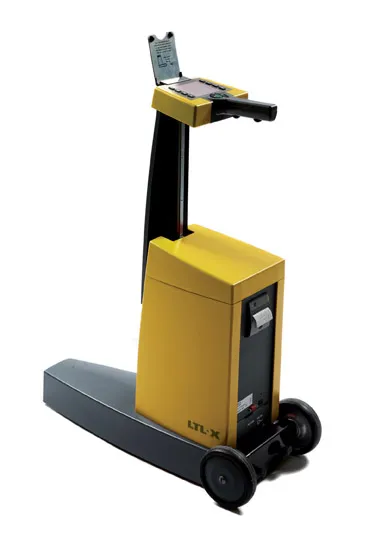
The LTL-XL from DELTA: built in modules

Box International studies have proven that relatively more accidents and fatalities happen during night-time driving compared to day-time driving.

At the end of 2008, Danish company 199 Delta launched its latest model, the LTL-XL, a fourth generation portable retrometer for measuring night and day-time visibility of all types of road markings.

"Measures are traceable to PTB (3998 Physikalisch-Technische Bundesanstalt), Germany and NIST (National Institute of Standards and Technology), USA. LTL-XL measures according to the international standards EN1436 and ASTM E-1710," says DELTA.

Its LTL-XL offers several new features compared to previous instruments from DELTA and these include the measuring of the ambient temperature and humidity; geotagging using GPS mapping software; USB connectivity and seamless connection to any system using a Web browser.
LTL-XL full instrument
The LTL-XL from DELTA: built in modules
The new equipment is offered with a new coloured display, single-handed operation and single touch controls, which makes the operator's work much easier.

Using LED technology, which makes the instrument almost maintenance free, LTL-XL allows users to work efficiently with measuring times of 1-3 seconds and a large memory of more than 200,000 measurements.

"LTL-XL is built in modules to allow the operator to design the instrument according to actual needs. It comes in a base model to which can be added wheels and telescopic handle, GPS and printer," says DELTA.

For more information on companies in this article

Related Content

  • Using aspahlt testing equipment improves efficiency
    May 28, 2013
    From density tests on a Mongolian gold mine project to an all-singing, all-dancing asphalt tester, Kristina Smith reports on some of the latest new products in materials testing. Perhaps understandably, nuclear density gauges can present contractors with some order to move them at all. “One of the problems with nuclear soil gauges is the restrictions on movement,” said John Lamond, Manufacturing. “If you are a contractor projects cross-border, it’s a real challenge to move a nuclear density gauge around.”
  • Real time site monitoring technology
    July 19, 2012
    Leica Geosystems is broadening its site monitoring technology with the introduction of the GeoMoS package. This can be linked to the firm's existing GNSS Spider software to offer an array of TPS and GNSS monitoring tools. Combined, these tools provide a web-based service for visualisation and analysis of monitoring. Authorised users can access a monitoring project using a web browser, pocket PC or mobile phone. Using the GeoMoS Web service, graphs and views can be customised and be tailored to the needs of
  • More satellites, more signals
    July 20, 2012
    Greater GPS accuracy suggests closer tolerances for surveying and machine control functions What happens in the future for GPS surveying and machine control could depend on satellite choice and signals. Right now there are around 30 satellites in orbit, largely built by the US, but by 2012 that could rise to 120 as Europe, China, India and Russia fully enter the market. A chequered history has faced the European's Galileo system. At long last, the finance appears to be in place and the European Commission a
  • Laser scanning focuses on asset management
    January 9, 2015
    Laser scanners and improved data collection and analysis software are making light of asset management surveying. David Arminas reports The age of the laser scanner is upon us, taking over from traditional manual methods of surveying, data collection and processing. These new technical developments are making it much easier to process and use the data captured and are providing highways engineers with powerful tools to record, map and visualise their assets. This is good news for highways authorities