Drone system from HCSS

HCSS says it is offering powerful new features for its HCSS Aerial package, a drone-based data analytics platform. This includes improvements with calculations and measurements, annotation and designs, and navigation. New features are said to optimise tablet performance and improve user experience with the mobile device.
October 22, 2021 Read time: 2 mins
HCSS is now offering improved functionality for its drone package

“Customers have asked us to allow HCSS Aerial measurements and quantities data to be integrated with HCSS HeavyJob Project Management and Job Cost solution,” said JP Giometti, vice president, Global Strategy and Corporate Development, HCSS. “We are Beta testing this integration and gathering feedback from clients before introduction. By integrating with HeavyJob, clients will be able to keep their jobs and budget on track with less expensive yet more accurate drone mapping.”

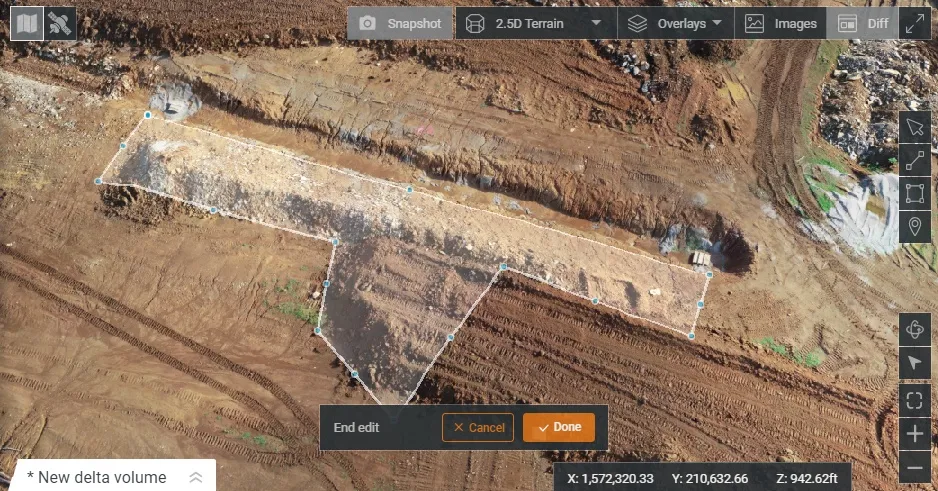
Features in the new update include the ability to provide measurements and analytics from design items, saving time, whether users are running calculations to compare design to the as-built for quality assurance or checking bills from subcontractors. The package can also eliminate any errors that might occur from manual drawing areas or lines. It can import images into HCSS Aerial to create a new annotation. The platform pins the annotation automatically, depending on the GPS position. Users inspecting a site on a tablet can import the photographs on the go. It offers easier drawing of lines and polygons for measurements and analytics.

Users can now make edits and adjust points in lines and polygons without starting calculations. The package can upload design files and notes before the first flight or while the flight is still being processed. A “Go to Coordinates” navigation tool can change a map display to a specific point by entering coordinates.

Measurement details for tablets optimises the small screen and allows users to choose between side navigation and a top-mounted calculation detail box.

For more information on companies in this article

Related Content

  • Brisbane’s Airport: Innovative Management of One of the World’s Busiest Runways
    June 26, 2014
    When it comes to runways, there are few busier then Brisbane’s main runway. Servicing both domestic and international travel, with over 200,000 movements per year, operating without a curfew Brisbane’s main runway is the busiest in Australia. For maintenance, crews only have a limited period of time to determine the pavement condition, normally during the night, making the detection of pavement faults difficult. To resolve this issue, a new high speed pavement scanner was used to rapidly survey the pavem
  • Bentley advances construction software technology
    December 19, 2016
    Design and construction software specialist Bentley Systems is strengthening its position in the market with the introduction of new software advances as well as a series of strategic business moves. This allows the company to offer new solutions and technologies to its client base, as well as reaching out to new business segments The firm is introducing an array of powerful tools to the market. A key launch is for the OpenRoads Designer CONNECT Edition, which is the successor to Bentley’s well-proven an
  • Don't buy, subscribe instead... and stay ahead of the pack
    September 19, 2024
    The traditional way of doing things is to own the construction equipment you need on site. You can buy, or you can rent. You mix and match your technology needs with what is happening on site and your costs go up and down accordingly. However, a new model is emerging: Subscriptions. Take out a flat-fee plan and let someone else make sure you can get access to the latest thinking and the cleverest technology. Pete Kennedy reports.
  • Asset management and BIM solutions offer cost efficiency
    May 22, 2018
    New technology will help deliver projects more efficiently – Mike Woof writes. An array of new software and hardware tools are coming to market that can boost working efficiency for construction projects. Technology company thinkWhere is helping to improve collaboration and communication on Scotland’s largest road infrastructure project. Providing online access to multiple layers of live project maps and geographical data, the firm’s groundMapper software offers a web-based viewer that is allowing the co