Drone system from HCSS

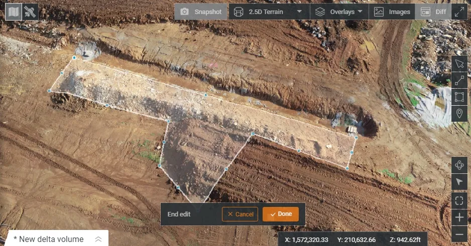
HCSS says it is offering powerful new features for its HCSS Aerial package, a drone-based data analytics platform. This includes improvements with calculations and measurements, annotation and designs, and navigation. New features are said to optimise tablet performance and improve user experience with the mobile device.
October 22, 2021 Read time: 2 mins
HCSS is now offering improved functionality for its drone package

“Customers have asked us to allow HCSS Aerial measurements and quantities data to be integrated with HCSS HeavyJob Project Management and Job Cost solution,” said JP Giometti, vice president, Global Strategy and Corporate Development, HCSS. “We are Beta testing this integration and gathering feedback from clients before introduction. By integrating with HeavyJob, clients will be able to keep their jobs and budget on track with less expensive yet more accurate drone mapping.”

Features in the new update include the ability to provide measurements and analytics from design items, saving time, whether users are running calculations to compare design to the as-built for quality assurance or checking bills from subcontractors. The package can also eliminate any errors that might occur from manual drawing areas or lines. It can import images into HCSS Aerial to create a new annotation. The platform pins the annotation automatically, depending on the GPS position. Users inspecting a site on a tablet can import the photographs on the go. It offers easier drawing of lines and polygons for measurements and analytics.

Users can now make edits and adjust points in lines and polygons without starting calculations. The package can upload design files and notes before the first flight or while the flight is still being processed. A “Go to Coordinates” navigation tool can change a map display to a specific point by entering coordinates.

Measurement details for tablets optimises the small screen and allows users to choose between side navigation and a top-mounted calculation detail box.

For more information on companies in this article

Related Content

  • Using technology so assess road surface quality
    April 4, 2014
    Advances in survey technology and the evolving face of road procurement are driving demand for highway condition data. Mark Thomas, infrastructure services manager at Fugro Aperio writes how surveys of new roads can improve long-term quality While a growing suite of non-intrusive testing, measurement and survey technologies are widely used to target highway repairs and to determine asset management strategies, the use of these powerful tools remains patchy in the early stages of the infrastructure life cycl
  • World of Asphalt report from Tennessee
    May 26, 2022
    Major manufacturers are offering a range of new compaction machines and technology to the market. Mike Woof reports from the recent World of Asphalt event in Nashville, Tennessee.
  • Intelligent paving tool from BOMAG
    April 9, 2025

    The innovative BOMAP Pave solution offers connected construction capabilities for paving works. BOMAG’s new system allows networking of pavers and rollers, boosting efficiency and quality in asphalt paving jobs.

    Pavers and asphalt rollers can be connected within an open, manufacturer-independent system. This allows control of the paving process from asphalt delivery to compaction. It provides users with full transparency in real time, reducing coordination effort and sustainably improving site processes.

  • The Road Ahead
    August 5, 2020
    According to recent figures, there are over 560,000 potholes that pose a risk of damage to vehicles in the UK alone, and the situation is similar in countries across the globe.