Versatile machine control package from Leica Geosystems

By Mike Woof April 25, 2024 Read time: 2 mins
Leica Geosystems is broadening its range of 3D solutions with its new iCON gps 120 antenna

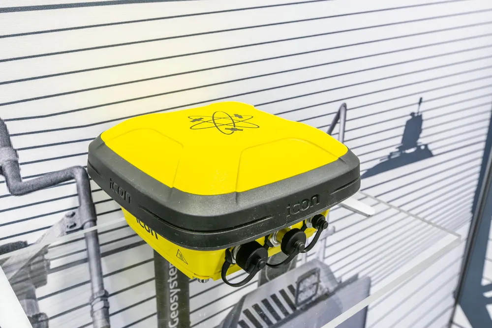
Leica Geosystems is widening its array of 3D machine control solutions with the introduction of its Leica iCON gps 120. This smart antenna offers customers a versatile machine control solution.

The nw Leica iCON 120 Machine Smart Antenna is integrated into the existing Leica MC1 solution platform and extends the machine control solution to more applications and machine types. Construction machines such as compaction rollers, which usually require only lower levels of accuracy without heading, can now be equipped with a tailor-made Leica MC1 machine control solution. This allows streamlined operations and consistent workflows between heavy construction equipment that vary in application requirements. Using the Leica MC1 machine control solution allows operators to carry out jobs more quickly and accurately, boosting fleet efficiency and reducing waste.

Construction customers can start with a single GNSS solution using a satellite-based augmentation system (SBAS) or HxGN SmartNet PPP service. If they need higher specifications, they can upgrade to an RTK solution with low or high accuracy by adding the communication unit Leica CR50. With a second iCON gps 120 Machine Smart Antenna, customers get a full high-accuracy dual GNSS solution with heading. A key feature of the design is that the antennas can be switched easily between Leica MC1 prepared machines due to the simple quick disconnect system.

“This solution is more versatile than our previous solution. You can take it from one machine to another and it’s perfect for rental machines. It’s an addition to our range, not a replacement for an existing unit,” according to Tommi Kauppinen, vice president, Heavy Construction, Machine Control Field Solutions at Leica Geosystems.
 

For more information on companies in this article

Related Content

  • Know what lies below with Leica’s DSX 3D utility detection system
    April 11, 2025

    Emergency road repair work needn’t create yet another emergency by hitting unknow utility pipes and other systems.  

    Leica Geosystems says its DSX utility detection solution can quickly be walked over the area where work is about to start and immediately show an excavator operator any dangers that lie below.

    It locates, visualises and map utilities. Unlike any other ground penetrating radar system, the Leica DSX maximises productivity with cutting-edge software that automates data analysis and creates a 3D utility map of the field.

  • Trimble and OEMs extend technology deal
    December 13, 2024
    Trimble is extending its technology deals with Caterpillar and John Deere.
  • Topcon and DAQRI co-developing new safety technology
    December 2, 2015
    Topcon Positioning is establishing a collaboration with DAQRI to develop wearable safety technology for use on construction sites. The two firms will work together to develop technology that will boost safety for site personnel through the use of augmented reality systems. DAQRI is a leader in enterprise augmented reality and developed the Smart Helmet, an industrial-grade unit that seamlessly connects personnel to work environments by providing information about the surroundings.
  • Smart asphalt paving technology in Morocco
    May 16, 2016
    SEFIANI Enterprises is staying competitive against rivals firms in the asphalt and paving construction market in Morocco. Construction Company SEFIANI Enterprises fitted one of its pavers with the Leica PaveSmart 3D machine control system at the end of October 2015. The aim of this was to improve project quality and to reduce operating costs for the 224km project for the LGV Ligne à Grande Vitesse Tanger–Kénitra. “It is the first system we sold for an asphalt paving application in Morocco,” explained