Sophisticated geopositioning tool from Topcon

Topcon says that its new T-18 handheld controller offers accuracy for geopositioning, construction, mapping and vertical construction applications. The controller includes a sunlight-readable display with a 1GHz processor, 1GB of internal storage, and up to 10 hours of battery life. “For MAGNET Field data collection, the T-18 controller offers a durable ergonomic solution with faster processing, a larger screen, better connectivity and longer battery life than previously available comparable systems,” said
October 9, 2018 Read time: 2 mins
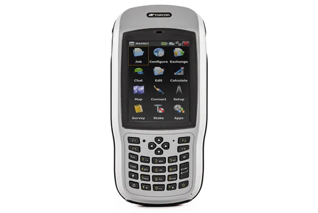
Topcon’s new T-18 unit offers advanced geopositioning capabilities
342 Topcon says that its new T-18 handheld controller offers accuracy for geopositioning, construction, mapping and vertical construction applications.  The controller includes a sunlight-readable display with a 1GHz processor, 1GB of internal storage, and up to 10 hours of battery life. “For MAGNET Field data collection, the T-18 controller offers a durable ergonomic solution with faster processing, a larger screen, better connectivity and longer battery life than previously available comparable systems,” said Ray Kerwin, director of global surveying products.


The T-18 features a 3.5G cellular modem for connectivity with Topcon MAGNET solutions for sending and receiving data to the cloud company account.  The firm says that the cellular option makes it easier to communicate with field crews when projects need to be changed or if important data is required back in the office. The modem can be used for RTK correction services. Additional key features include standard Bluetooth and Wi-Fi connectivity, as well as an IP65 rating for dust and water protection in demanding job site conditions.

For more information on companies in this article

Related Content

  • Positioning tools from Topcon
    November 15, 2012
    Topcon is offering an array of new tools that can improve surveying and machine control capabilities for contractors. Light and compact, the B110 dual-frequency positioning receiver board features the new Vanguard ASIC system and can support 226 universal channels for GPS, GLONASS and Galileo tracking and scalable positioning. The B110 board’s small size, low power consumption and versatile communication interfaces make it easy to integrate into any precise positioning application. It features a high perfor
  • Topcon’s PS-AS series to “set a new industry standard” for robotic total stations
    January 6, 2017
    Topcon Europe Positioning’s (TEP) new auto-tracking robotic total station series for the construction market on show at bauma 2013 will “set a new industry standard”, according to Leighton Davies, the company’s survey products sales manager for Europe. With what is said to be its combination of the latest tracking, motorised turning, angle accuracy and software technology, the new PS-AS series instruments are designed for applications such as stakeout and as a key component of a Local Positioning System, us
  • Topcon’s PS-AS series to “set a new industry standard” for robotic total stations
    January 30, 2013
    Topcon Europe Positioning’s (TEP) new auto-tracking robotic total station series for the construction market on show at bauma 2013 will “set a new industry standard”, according to Leighton Davies, the company’s survey products sales manager for Europe. With what is said to be its combination of the latest tracking, motorised turning, angle accuracy and software technology, the new PS-AS series instruments are designed for applications such as stakeout and as a key component of a Local Positioning System, us
  • Topcon announces increased 3D scanning integration with Autodesk
    August 17, 2015
    Topcon Positioning Group says it has improved workflow compatibility for the GLS-2000 3D laser scanner and ScanMaster software with Autodesk solutions. With the latest version of Autodesk ReCap, the GLS-2000 pairs with Topcon ScanMaster software to collect, process, edit and deliver 3D point cloud data from a laser scanner. ReCap allows users to perform tasks such as scan conversion, editing and viewing point cloud data. It also provides integration with Autodesk’s portfolio of design software. Aut