Site visibility with Volvo CE Connected Map

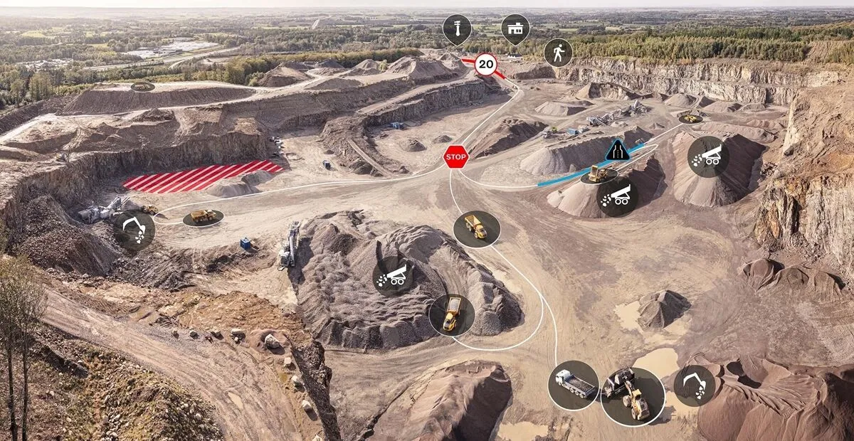
Connected Map will display many typical site features and landmarks, including roads, to help operators navigate the site.
By Guy Woodford April 16, 2024 Read time: 2 mins
Volvo CE Connected Map offers users complete visibility of their job site

Volvo Construction Equipment’s (Volvo CE) Connected Map provides complete visibility of the job site by giving a real-time visual overview of the position of every machine, vehicle and visitor on a customer's site.

The intelligent positioning service can be accessed by all site personnel, both in the machine (via Volvo Co-Pilot or an Android/iOS device) and in the office (via the Office portal).

Connected Map will display many typical site features and landmarks, including roads to help operators navigate the site, loading zones, unloading zones, speed zones and restricted areas. Points of interest such as offices, workshops, and service stations can also be visualised, which is particularly useful for new or temporary operators. Single-lane (narrow road) sections can be defined as warning the operator if another machine is approaching in a single-lane section, helping to avoid traffic jams.

Connected Map users can also stay informed about the location of their machines, thanks to Connected Map's search functionality, which will search and find users or machines in real-time, with the machine's last position visible for 30 days. Away from the office, Connected Map makes it easier for the operator to familiarise themselves with the site and know where everyone is, including visitors, helping to facilitate a simpler, safer and less stressful operation.

For more information on companies in this article

Related Content

  • Traffic management software tools
    March 5, 2012
    A joint development project between Delcan Corporation and Intelligent Devices Incorporated (IDI) has resulted in the sophisticated Intelligent NETworks product. This is an integrated product that combines the IDI Intelligent Control NTCIP system with the Delcan advanced transportation applications of NETworks. The system can be linked to dynamic message signs (DMS), CCTV and vehicle detector stations (VDS), traffic intersections, as well as environment road weather sensor stations.
  • Free modeling: Improving efficiency in construction- site management
    July 24, 2025
    Liebherr’s innovative Free Modeling technology enables road-construction operators to create and modify simple 3D site models directly from their machinery, enhancing real-time decision-making.
  • Traffic control solution manufacturers win key project works
    September 26, 2013
    Traffic control system manufacturers have recently supplied some of their cutting-edge technology to major projects in Europe. Meanwhile, in southern Asia, another leading firm in the sector is helping reduce chronic traffic congestion in Indonesia’s capital, Jakarta. Guy Woodford reports Solutions supplied by Siemens Mobility & Logistics (M&L) are helping the Rijkswaterstaat improve traffic conditions at the Coentunnel in Amsterdam, one of the most heavily used traffic arteries in the Netherlands, used
  • Plantworx 2013 focus on latest safety technology for worksite vehicles
    November 28, 2012
    Plantworx 2013 will showcase the latest worksite vehicle safety systems. GKD Technik’s (GKD) Incline Alert system will be among those featured at the UK’s largest construction show, spanning 100,000m², being held at Stoneleigh Park, Coventry Warwickshire on 16 May, 2013. The system is said by GKD to have been developed to meet a need for incline monitoring in the construction and utility maintenance industries, particularly for smaller excavators, which carry a higher risk of overturning when operating on i