Site visibility with Volvo CE Connected Map

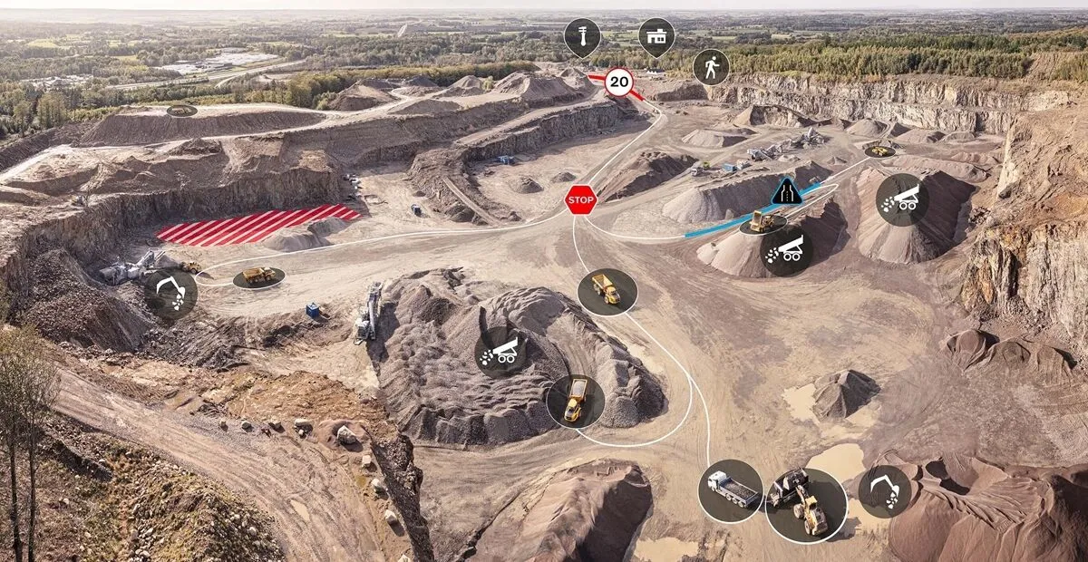
Connected Map will display many typical site features and landmarks, including roads, to help operators navigate the site.
By Guy Woodford April 16, 2024 Read time: 2 mins
Volvo CE Connected Map offers users complete visibility of their job site

Volvo Construction Equipment’s (Volvo CE) Connected Map provides complete visibility of the job site by giving a real-time visual overview of the position of every machine, vehicle and visitor on a customer's site.

The intelligent positioning service can be accessed by all site personnel, both in the machine (via Volvo Co-Pilot or an Android/iOS device) and in the office (via the Office portal).

Connected Map will display many typical site features and landmarks, including roads to help operators navigate the site, loading zones, unloading zones, speed zones and restricted areas. Points of interest such as offices, workshops, and service stations can also be visualised, which is particularly useful for new or temporary operators. Single-lane (narrow road) sections can be defined as warning the operator if another machine is approaching in a single-lane section, helping to avoid traffic jams.

Connected Map users can also stay informed about the location of their machines, thanks to Connected Map's search functionality, which will search and find users or machines in real-time, with the machine's last position visible for 30 days. Away from the office, Connected Map makes it easier for the operator to familiarise themselves with the site and know where everyone is, including visitors, helping to facilitate a simpler, safer and less stressful operation.

For more information on companies in this article

Related Content

  • Kramer keeps track of machines online
    February 26, 2013
    Kramer says the new wheeled loaders it is bringing to Bauma are “ideal for road and highway construction.” The new Kramer 550 and 650 wheeled loaders, which will make their debut alongside the company’s existing Kramer 850, 580 and 780 models, mean that the firm’s portfolio can now offer bucket volumes from 0.35m³ to 1.50m³. The German manufacturer is especially proud of the high payload capacity of 1,750kg on the Kramer 650, which can travel at a speed of 30km/h. Away from the wheeled loaders, Kramer is al
  • VIDEO: Telstra drone LIDAR maps Melbourne’s EastLink Mullum Tunnel
    April 13, 2018
    One of the applications for LIDAR is to make high resolution 3-D maps. Self-driving cars are pre-loaded with a LIDAR map of the trials area in which they are permitted to fully self-drive themselves. The cars also have their own LIDAR scanner which captures a real-time LIDAR view of the vehicle’s surroundings. The fully autonomous driving system within these prototype cars compares the real-time LIDAR view against the pre-loaded LIDAR map to significantly increase the accuracy of their self-positioning
  • Efficient asphalt delivery with new tool
    February 23, 2018
    Aggregate Industries is now offering an upgraded Express Asphalt App, which is said to make life easier for customers. This is one of many new digital tools now being introduced by asphalt producers around the globe, intended to ease logistics. The firm’s new app comes with innovative new features such as information on tools and equipment and a dedicated section for case studies. Called the Express Asphalt App, the upgraded version offers an improved tonnage calculator. The firm says that this enables
  • Machine control technology round table discussion with Leica Geosystems, Topcon and Trimble
    January 4, 2022
    In this, the first in a series of top-level roundtable discussions led by World Highways, editor Mike Woof and editorial director Geoff Hadwick talk machine control technology with three world-class experts from Leica Geosystems, part of Hexagon, Topcon and Trimble. Find out what these key opinion leaders are thinking on six vitally important topics. Let them help you stay ahead of the game.