Picture perfect from Leica

Advanced imaging capability has been added to the Leica ScanStation C10 laser scanner. The new option consists of a direct digital camera mount on the ScanStation C10 scanner and tight, automated integration of external camera images into the scanner’s on-board controller and data storage system. Cyclone v7.4 supports the new option.
July 18, 2012 Read time: 2 mins
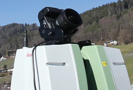
Advanced imaging capability has been added to the Leica ScanStation C10 laser scanner.

The new option consists of a direct digital camera mount on the ScanStation C10 scanner and tight, automated integration of external camera images into the scanner’s on-board controller and data storage system. Cyclone v7.4 supports the new option.

265 Leica Geosystems (LG) said ScanStation C10 users will continue to have the option of using the scanner’s convenient, embedded camera for taking precisely aligned, high-resolution digital pictures of the surrounding scene.

The company’s ScanStation C5 with internal camera option can also be used with the new external camera option.

With the growing popularity of powerful point cloud viewing software capabilities like TruView, Cyclone TruSpace, and fly-through movies, users are said by LG to be increasingly taking advantage of high-end external camera imagery with point cloud data.

Previously, applying such quality external imagery involved removing a scanner head from its tripod; placing a high-end camera on the same tripod; taking 360º full-dome pictures; and then using third party software tools to apply the full dome imagery to the point cloud data. This method added up to15-30 minutes per scanner setup. The new integrated, automated external camera option is said to cut the total time to less than 5 minutes per setup. With dozens of setups a day typical, the new option saves many hours each day. New commands for the integrated, external camera facility are in ScanStation C10 firmware v2.70.

Meanwhile, optional external camera support exists for an 18 Megapixel Canon EOS 60D camera. An External Camera Mounting Kit includes a bracket for this camera that conveniently attaches to the ScanStation C10’s removable carry handle slot, plus a USB cable that connects the camera to the scanner for camera control from the scanner and for automatic image transfer.

In addition to supporting the new External Camera option, Cyclone 7.4 also has the ‘Gradient Display’ point cloud display feature. It provides users with several gradient display backgrounds for point clouds, such as a blue sky and brown ground in places where there is no point cloud data, making the appearance of point cloud data more familiar to new users.

For more information on companies in this article

Related Content

  • Leica Cyclone teams up with NCTech’s iSTAR camera database
    January 19, 2016
    Users of Leica Cyclone, a 3D point cloud processing software, can now automatically import and align high-dynamic range (HDR) data from NCTech’s iSTAR camera database. The result is enhanced images delivered faster and easier, according to both companies. “It is also the accuracy to which these images fit the 3D point cloud data that is paramount. NCTech’s iSTAR camera produces high-quality HDR imaging at the accuracy everyone expects,” said Faheem Khan, vice president, business development for Leica Geosys
  • Sophisticated scanning tool from Leica Geosystems
    November 8, 2017
    A new laser scanning tool from Leica Geosystems offers accurate and fast 3D imaging laser scanning capabilities. The Leica BLK360 is said to be compact and easy to use, offering powerful spherical image capture duties. The firm says that the unit allows professionals to capture 360° imagery within minutes.
  • Positioning tools continue to improve
    July 16, 2012
    Topcon says that its new IP-S2 package combines GNNS positioning capabilities with inertial sensors, while the firm also has a solution for customers wanting to mix and match receiver components. The IP-S2 is a vehicle-mounted, mobile 3D tool that offers precision mapping and surveying capabilities. The package collects data using 3D laser scanners, LIDAR, and/or cameras, and this is then integrated, time-stamped and geo-referenced. The customer can use this assembled data to combine LIDAR point cloud and d
  • Laser scanning focuses on asset management
    January 9, 2015
    Laser scanners and improved data collection and analysis software are making light of asset management surveying. David Arminas reports The age of the laser scanner is upon us, taking over from traditional manual methods of surveying, data collection and processing. These new technical developments are making it much easier to process and use the data captured and are providing highways engineers with powerful tools to record, map and visualise their assets. This is good news for highways authorities