Fast field data collection

Trimble's sophisticated TSC3 controller is designed to allow surveyors and geospatial professionals to collect, share and deliver data. This unit is said to improve accuracy, efficiency and productivity between the field and office and is designed to be used with the Trimble Access software. The TSC3 controller offers fast and reliable data collection, computing and connectivity capabilities and provides multiple functions in a single handheld device. The unit incorporates a digital camera, integrated commu
February 10, 2012 Read time: 2 mins
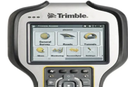
2122 Trimble's sophisticated TSC3 controller is designed to allow surveyors and geospatial professionals to collect, share and deliver data. This unit is said to improve accuracy, efficiency and productivity between the field and office and is designed to be used with the Trimble Access software. The TSC3 controller offers fast and reliable data collection, computing and connectivity capabilities and provides multiple functions in a single handheld device. The unit incorporates a digital camera, integrated communications as well as a GPS navigator, compass and accelerometer.

Using this device, surveyors can include on-site photos in surveys, communicate efficiently between field and office and streamline stakeout activities. The durable Trimble TSC3 controller has a high-resolution, sunlight-readable touchscreen display, integrated Wi-Fi and Bluetooth wireless capabilities and long battery life. Users can also choose either a QWERTY or ABC alphanumeric keyboard.

Delivered with Trimble Access software installed as well as the capability to run third-party applications on the Windows platform, the TSC3 is a comprehensive data collection solution for the survey industry. The Trimble TSC3 controller has wireless Internet connectivity through either the integrated GSM/GPRS modem or Wi-Fi. Data collection, processing, analysis, and delivery duties are said to be faster and more efficient.

For more information on companies in this article

Related Content

  • Improved laser scanning capabilities
    February 23, 2012
    Leica Geosystems is broadening its software offering with its new Leica Cyclone v7.2 package, which is said to improve office processing capabilities. The package has been developed to address key market needs and trends in the processing and use of rich, as-built point cloud data from high definition laser scanning technology. According to the firm the package can help reduce laser scanning project costs, including office time, allowing projects to use more scans and higher scan densities.
  • Smart constructioon with GIS, GPS design technology
    February 16, 2012
    A UK highway project has benefited from the latest software, GIS and GPS technology, Mike Woof reports. Sophisticated software, GIS and GPS technology has played an important role in a large highway upgrade project in the UK and helping to increase efficiency and drive down construction costs.
  • Ferrovial 5G for Silvertown sites in London
    October 18, 2021
    The 5G network has been deployed in partnership with Nokia and Telent for work on the tunnel that will connect London’s Greenwich Peninsula and Silvertown district.
  • Asset management and BIM solutions offer cost efficiency
    May 22, 2018
    New technology will help deliver projects more efficiently – Mike Woof writes. An array of new software and hardware tools are coming to market that can boost working efficiency for construction projects. Technology company thinkWhere is helping to improve collaboration and communication on Scotland’s largest road infrastructure project. Providing online access to multiple layers of live project maps and geographical data, the firm’s groundMapper software offers a web-based viewer that is allowing the co