Fast field data collection

Trimble's sophisticated TSC3 controller is designed to allow surveyors and geospatial professionals to collect, share and deliver data. This unit is said to improve accuracy, efficiency and productivity between the field and office and is designed to be used with the Trimble Access software. The TSC3 controller offers fast and reliable data collection, computing and connectivity capabilities and provides multiple functions in a single handheld device. The unit incorporates a digital camera, integrated commu
February 10, 2012 Read time: 2 mins
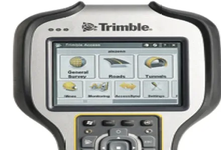
2122 Trimble's sophisticated TSC3 controller is designed to allow surveyors and geospatial professionals to collect, share and deliver data. This unit is said to improve accuracy, efficiency and productivity between the field and office and is designed to be used with the Trimble Access software. The TSC3 controller offers fast and reliable data collection, computing and connectivity capabilities and provides multiple functions in a single handheld device. The unit incorporates a digital camera, integrated communications as well as a GPS navigator, compass and accelerometer.

Using this device, surveyors can include on-site photos in surveys, communicate efficiently between field and office and streamline stakeout activities. The durable Trimble TSC3 controller has a high-resolution, sunlight-readable touchscreen display, integrated Wi-Fi and Bluetooth wireless capabilities and long battery life. Users can also choose either a QWERTY or ABC alphanumeric keyboard.

Delivered with Trimble Access software installed as well as the capability to run third-party applications on the Windows platform, the TSC3 is a comprehensive data collection solution for the survey industry. The Trimble TSC3 controller has wireless Internet connectivity through either the integrated GSM/GPRS modem or Wi-Fi. Data collection, processing, analysis, and delivery duties are said to be faster and more efficient.

For more information on companies in this article

Related Content

  • Topcon introduces sophisticated GIS technology
    November 20, 2014
    Topcon Positioning Group is broadening its range of GIS solutions with the introduction of the new FC-500 data controller and MAGNET Relay package. The FC-500 unit features a large, bright sunlight-readable display and is compatible with either the Topcon eGIS or MAGNET Field GIS software.
  • Data handling for efficient machine control
    October 16, 2012
    The rapid increase in information availability is transforming the construction sector. Conventional methods used for sourcing geographic data based on maps and localised sampling meant that there was often a lack of accurate information relating to ground conditions at specific areas where work was planned, often resulting in unwelcome surprises for construction companies along with additional costs for projects.
  • Leica’s high-tech 5
    August 14, 2012
    The new Leica Zeno 5 is said to be an entrylevel, rugged personal digital assistant (PDA) for organisations that require a durable compact device with integrated modem and high-sensitive GPS. The Leica Geosystems technology supports field workers by combining a mobile phone with asset collection and management capabilities. The Leica Zeno 5 is said to be shock resistant, withstands a drop from to 1.8m, and is protected against water and dust. The large 9.4cm screen is optimised for sunlight readability and
  • Trimble offering sophisticated package of solutions
    February 2, 2015
    Trimble says that its latest Connected Site solutions offer improved efficiency for connecting workers, machines and projects across the planning, design and construction lifecycle. These technologies suit use by heavy civil contactors and site preparation contractors. Trimble’s mix of hardware, software and mobility technologies streamlines communication and collaboration throughout the construction lifecycle, from planning, design and site preparation through to the finished project. Connecting people