As World Highways was going to press Autodesk was due to announce the 2014 versions of its entire range of programs including AutoCAD, Civil 3D, NavisWorks and Revit Structural and others programs used by the road industry. As previously, they are packaged in suites; Standard, Premium and Ultimate. Key aspects focus around the inclusion of a completely new and fast point-cloud “engine” developed from the Alice Labs company acquisition made last year. Part of a new Autodesk Recap, standing for reality captur

As 3260 World Highways was going to press 685 Autodesk was due to announce the 2014 versions of its entire range of programs including AutoCAD, Civil 3D, NavisWorks and Revit Structural and others programs used by the road industry. As previously, they are packaged in suites; Standard, Premium and Ultimate.
Key aspects focus around the inclusion of a completely new and fast point-cloud “engine” developed from the Alice Labs company acquisition made last year. Part of a new Autodesk Recap, standing for reality capture, this will be able to open point-clouds in the main tools used in civil engineering such as Map, Civil 3D and Revit. Recap is included in all of them. The company says the new engine is fast, inputs most of the major formats, and can translate point-clouds into different local coordinate systems to match other data.
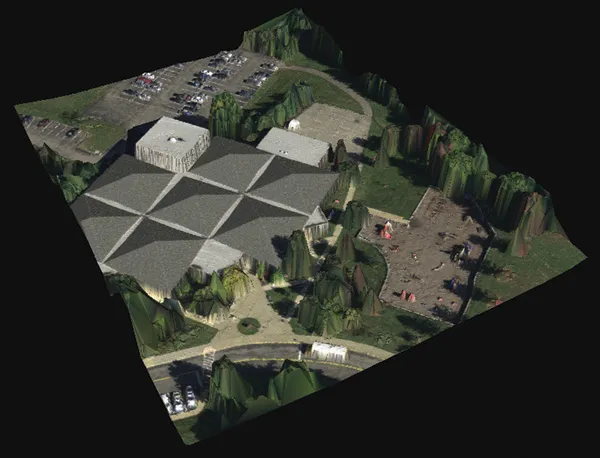
The Infrastructure Modeller tool, for conceptualising projects and testing sketch scenarios is now relaunched as a enhanced version, re-named InfraWorks.
In the Ultimate suite this will include roads and highway modules which allow early design sketches to be done with precision data, so that they can be imported directly into Civil 3D for further work. It will also link to the cloud for tasks like optimisation of the vertical alignment
– part of a general philosophy for all Autodesk products using more "infinite" computing power of the cloud for heavy "grunt" work, instead of the local desktop. Rendering capacity is another aspect.
The cloud will also be used for communication, and design and construction collaboration, with BIM360 Glue, a cloud accessed tool for design integration and class detection, which is a “NavisWorks light" - accessed via a very small client application with full high quality graphics whatever the capacities of the local laptop.
Key aspects focus around the inclusion of a completely new and fast point-cloud “engine” developed from the Alice Labs company acquisition made last year. Part of a new Autodesk Recap, standing for reality capture, this will be able to open point-clouds in the main tools used in civil engineering such as Map, Civil 3D and Revit. Recap is included in all of them. The company says the new engine is fast, inputs most of the major formats, and can translate point-clouds into different local coordinate systems to match other data.
The Infrastructure Modeller tool, for conceptualising projects and testing sketch scenarios is now relaunched as a enhanced version, re-named InfraWorks.
In the Ultimate suite this will include roads and highway modules which allow early design sketches to be done with precision data, so that they can be imported directly into Civil 3D for further work. It will also link to the cloud for tasks like optimisation of the vertical alignment
– part of a general philosophy for all Autodesk products using more "infinite" computing power of the cloud for heavy "grunt" work, instead of the local desktop. Rendering capacity is another aspect.
The cloud will also be used for communication, and design and construction collaboration, with BIM360 Glue, a cloud accessed tool for design integration and class detection, which is a “NavisWorks light" - accessed via a very small client application with full high quality graphics whatever the capacities of the local laptop.