Savoy swept-path

Savoy Computing in the UK has been quick to launch a new version of its AutoTrack swept-path analysis software to take advantage of the latest AutoCAD 2012 platform.
February 21, 2012 Read time: 2 mins
2902 Savoy Computing in the UK has been quick to launch a new version of its AutoTrack swept-path analysis software to take advantage of the latest AutoCAD 2012 platform.

AutoTrack v9.10 has full native support for all AutoCAD 2012 and the products that sit above it such as Civil 3D in 32-bit and 64-bit variants.

A key feature now is that the drawing algorithms in AutoTrack take advantage of speed enhancements in AutoCAD, especially the temporary graphics displayed while grip editing and dragging. It gives a much more responsive feel says Savoy.

A context-sensitive AutoTrack ribbon has been programmed in so that clicking an AutoTrack object will automatically display the AutoTrack menu ribbon.

BLOB, Savoy's swept-path analysis software, is to be sold in Brazil by N A Tecnologia which becomes an authorised distributor and Savoy Partner. The Brazilian firm provides software, support and training to engineers in Brazil and South America.

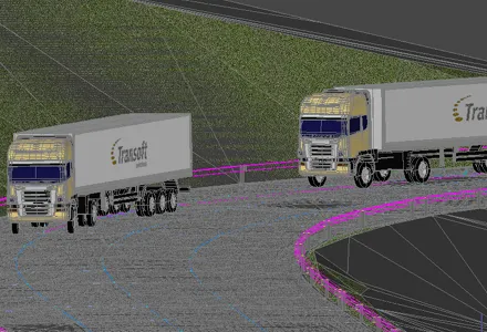
Canadian software house 349 Transoft Solutions has taken vehicle swept-path analysis to a new level with the launch of a three-dimensional version of its AutoTURN analyser.

AutoTURN Pro 3D is based on the same calculation engine as the original program, now in version 8, but works with a three-dimensional design view of a road and its junctions based on a digital terrain model. Alternatively a 2D design can be projected onto a DTM says Transoft.

Using a set of special tools the user pulls along a vehicle selected from an extensive library of international vehicle types which the firm says are accurate in detail and dimensions, and the program then calculates the swept-path both horizontally and vertically, alerting the designer to obstacles and terrain conflicts.

It finds ground clearance, distance to objects and height limitations.

A punch-through cross-section can be seen at any point and the program can be used for visualisations for client presentations after the design has been tweaked.


For more information on companies in this article

Related Content

  • Precision narrows the gap between design software and GIS
    March 20, 2012
    Greater precision is helping blur the boundaries between GIS technology and design software While GIS map based technology has extended its range across an ever more universal spectrum of uses in the highways sector, it is increasingly showing weaknesses for engineering purposes. It is very often not accurate enough. This has not mattered previously because the GIS tool has been seen essentially as an automated version of paper based systems from the design department's point of view. Where engineers
  • New functionality for infrasfructure design software
    March 20, 2012
    Chris Bradshaw, Autodesk's vice-president for the Infrastructure Solutions division spoke to World Highways. The launch of the fourth version of its Civil 3D design software early this year will see software maker Autodesk getting serious about its road and general civil engineering package. Bigger projects can be handled in the 2008 version, and a range of new functionality is being added. "Though not everything we would like yet," said Chris Bradshaw, Autodesk's vicepresident for the Infrastructure S
  • Use 3D modelling to advance sustainable highway construction best practices
    April 30, 2025
    When it comes to advancing highway sustainability, the role of 3D modeling and digital technologies in road construction is becoming ever-more important. Anna Liza Montenegro, director of marketing at Microsol Resources explains why your business needs to get involved now.
  • Sophisticated software solutions offering surveying innovation and construction efficiency
    August 28, 2014
    An array of new software tools will deliver greater efficiencies to construction companies – Mike Woof writes. Sophisticated software systems are delivering advanced solutions to traditional construction tasks. Key developments have been made by major players in the sector, such as Bentley Systems, Fugro Roadware, Leica Geosystems and Topcon Sokkia. From Bentley comes a new package that will help road construction activities in urban areas featuring a heavy concentration of underground utilities. This n