Chris Bradshaw, Autodesk's vice-president for the Infrastructure Solutions division spoke to World Highways. The launch of the fourth version of its Civil 3D design software early this year will see software maker Autodesk getting serious about its road and general civil engineering package. Bigger projects can be handled in the 2008 version, and a range of new functionality is being added. "Though not everything we would like yet," said Chris Bradshaw, Autodesk's vicepresident for the Infrastructure S
RSS685 Autodesk getting serious about its road and general civil engineering package. Bigger projects can be handled in the 2008 version, and a range of new functionality is being added.
"Though not everything we would like yet," said Chris Bradshaw, Autodesk's vicepresident for the Infrastructure Solutions division, who thinks that the package has more potential to offer.
Bradshaw says the program has already made strong running from its initial launch around four years ago. Then it was pitched largely at small-medium firms handling local and regional projects such as small road networks. But he thinks it is a contender for the national and international schemes like long distance highways.
"The important thing is that it has been a true model based system from the beginning of its development" he explained. "That is to say all the information about a project is held, and the analysis and design is done, on a three dimensional model stored as three dimensional information inside a relational database. That is very different to having data represented as arcs, lines, curves and circles from which a 3D representation is generated." The data representation comes first and from that, drawings, quantities and images can be generated. Advantages include the ability for drawings and sections to be taken from any plane and at any angle.
"Most importantly it means the system can be dynamic. Since everything about your design springs from the model, any changes to the model can be reflected everywhere else," Bradshaw said. "Change one thing and you can have alignments, and positions of other elements throughout the project updated.
Quantities are revised and coordinates adjusted for everything within the design." These offer both productivity gains and new ways of working.
"When all the worksheets are updated automatically, this can save enormous amounts of effort updating perhaps hundreds or thousands of related drawings and documents," he said.
Mistakes are less likely because there are no forgotten drawings or figures as because everything draws its data from a single database. The tedious side of the work is eliminated, he points out.
"And all the versions are tracked so that the newest is always clear," he added.
Removing these tasks allows the engineer to be more creative or analytical. He said, "There is the opportunity to make more last minute changes to designs for example, or do 'what if' variations." That could facilitate the increasingly important contractor designed scheme, where changes are needed to accommodate best construction technique.
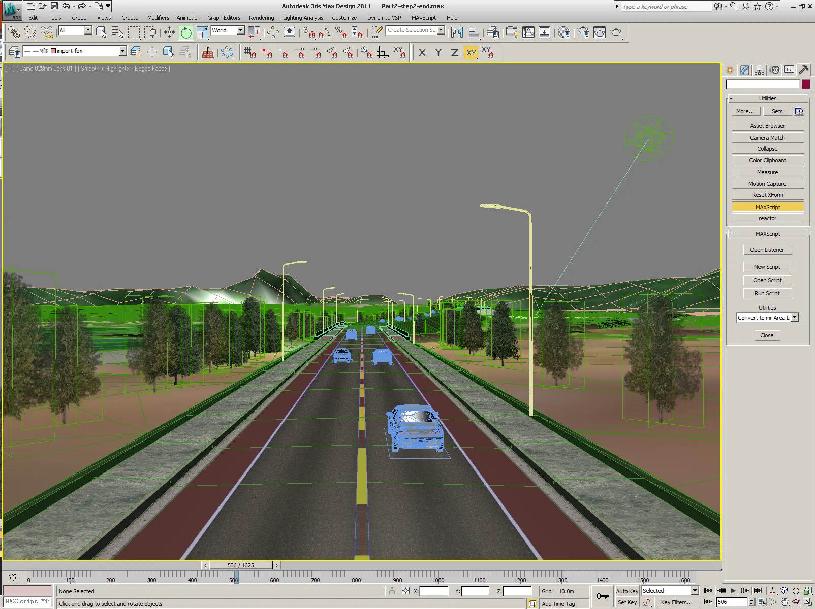
The 3D model is a powerful starting point too for generating visual representation of a design, allowing video images to be created and for virtual reality representations to be generated and walked around.
A simple visual representation also helps in design work and Civil 3D offers rendering tools to allow the current stage of a project to be examined. "The internal renderer will never match virtual reality programs," conceded Bradshaw, "but it is reasonably good and will improve." Some of these capacities are present in other packages of course, or can be added by modules or extensions. Bradshaw conceded that major rival4019 Bentley Systems' road programs also have 3D cores.
And the Norwegian originated357 Novapoint system, based around the 3282 AutoCAD format and a partner of Autodesk, is a full 3D package with a central modelling core and a large range of modules for various functions.
But he argued that Civil-3D, being new from the ground up, is the only one to offer a completely integrated tool. In it, he said, there is no need to make secondary adjustments and changes when the design is altered.
A previous disadvantage of Civil 3D has been data handling. He said, "We have been surprised by the vast data sets that projects require, they are astounding." But some of that has been dealt with already and will be further improved in the future. "It is not a limitation of file formats. There is no architectural problem in scaling up the capacities and we will soon be back to hardware limits," he said.
Major projects are likely to benefit from significant development in the collaboration tools in the program. The Vault system tracks changes and also allows for work to be split up and different elements to be worked on simultaneously.
Working in teams has been part of the package from the beginning but was much strengthened in the 2007 version and is likely to be improved in the next version.
Bradshaw says this is not something that an external document tracking or collaboration tool can do so well and is not the same as pooling information in external project data stores, such as Autodesk's own Buzzsaw.RSS
Chris Bradshaw, Autodesk's vice-president for the Infrastructure Solutions division spoke to World Highways
The launch of the fourth version of its Civil 3D design software early this year will see software maker"Though not everything we would like yet," said Chris Bradshaw, Autodesk's vicepresident for the Infrastructure Solutions division, who thinks that the package has more potential to offer.
Bradshaw says the program has already made strong running from its initial launch around four years ago. Then it was pitched largely at small-medium firms handling local and regional projects such as small road networks. But he thinks it is a contender for the national and international schemes like long distance highways.
"The important thing is that it has been a true model based system from the beginning of its development" he explained. "That is to say all the information about a project is held, and the analysis and design is done, on a three dimensional model stored as three dimensional information inside a relational database. That is very different to having data represented as arcs, lines, curves and circles from which a 3D representation is generated." The data representation comes first and from that, drawings, quantities and images can be generated. Advantages include the ability for drawings and sections to be taken from any plane and at any angle.
"Most importantly it means the system can be dynamic. Since everything about your design springs from the model, any changes to the model can be reflected everywhere else," Bradshaw said. "Change one thing and you can have alignments, and positions of other elements throughout the project updated.
Quantities are revised and coordinates adjusted for everything within the design." These offer both productivity gains and new ways of working.
"When all the worksheets are updated automatically, this can save enormous amounts of effort updating perhaps hundreds or thousands of related drawings and documents," he said.
Mistakes are less likely because there are no forgotten drawings or figures as because everything draws its data from a single database. The tedious side of the work is eliminated, he points out.
"And all the versions are tracked so that the newest is always clear," he added.
Removing these tasks allows the engineer to be more creative or analytical. He said, "There is the opportunity to make more last minute changes to designs for example, or do 'what if' variations." That could facilitate the increasingly important contractor designed scheme, where changes are needed to accommodate best construction technique.
The 3D model is a powerful starting point too for generating visual representation of a design, allowing video images to be created and for virtual reality representations to be generated and walked around.
A simple visual representation also helps in design work and Civil 3D offers rendering tools to allow the current stage of a project to be examined. "The internal renderer will never match virtual reality programs," conceded Bradshaw, "but it is reasonably good and will improve." Some of these capacities are present in other packages of course, or can be added by modules or extensions. Bradshaw conceded that major rival
And the Norwegian originated
But he argued that Civil-3D, being new from the ground up, is the only one to offer a completely integrated tool. In it, he said, there is no need to make secondary adjustments and changes when the design is altered.
A previous disadvantage of Civil 3D has been data handling. He said, "We have been surprised by the vast data sets that projects require, they are astounding." But some of that has been dealt with already and will be further improved in the future. "It is not a limitation of file formats. There is no architectural problem in scaling up the capacities and we will soon be back to hardware limits," he said.
Major projects are likely to benefit from significant development in the collaboration tools in the program. The Vault system tracks changes and also allows for work to be split up and different elements to be worked on simultaneously.
Working in teams has been part of the package from the beginning but was much strengthened in the 2007 version and is likely to be improved in the next version.
Bradshaw says this is not something that an external document tracking or collaboration tool can do so well and is not the same as pooling information in external project data stores, such as Autodesk's own Buzzsaw.RSS