
Construction software giant Autodesk continues to acquire new capabilities and products

Even before its annual spring upgrade announcements, covering all the major software from AutoCAD to Civil 3D, the giant Autodesk has been releasing a stream of changes. Some of these cover recent acquisitions such as the French Graitec software for detailing and design of concrete and steel structures, now through its legal processes, and the Bestech acquisition. In both cases the software is re-released under an Autodesk brand to ensure continuity for users "and with a price reduction," said Autodesk c
May 16, 2014 Read time: 3 mins
The InfraWorks package from Autodesk is being rapidly developed with additional functionality

Construction software giant Autodesk continues to acquire new capacities

Even before its annual spring upgrade announcements, covering all the major software from 3282 AutoCAD to Civil 3D, the giant 685 Autodesk has been releasing a stream of changes.

Some of these cover recent acquisitions such as the French Graitec software for detailing and design of concrete and steel structures, now through its legal processes, and the Bestech acquisition. In both cases the software is re-released under an Autodesk brand to ensure continuity for users "and with a price reduction," said Autodesk civil industry manager, Jack Strongitharm.

For the time being the Bestech bridge design program will now be known as Autodesk Structural Bridge Design, but both programs will be more closely integrated with other products in the coming period.

Further widening its spectrum, for the first time into traffic analysis and simulation, Autodesk also recently acquired Azalient Technology, another UK firm, which makes a microsimulation tool. Unusually this will not immediately be re-badged but will "go dark" to be worked on for part of background capabilities of the company's software portfolio, in the way that laser point cloud engines or other technologies have done.


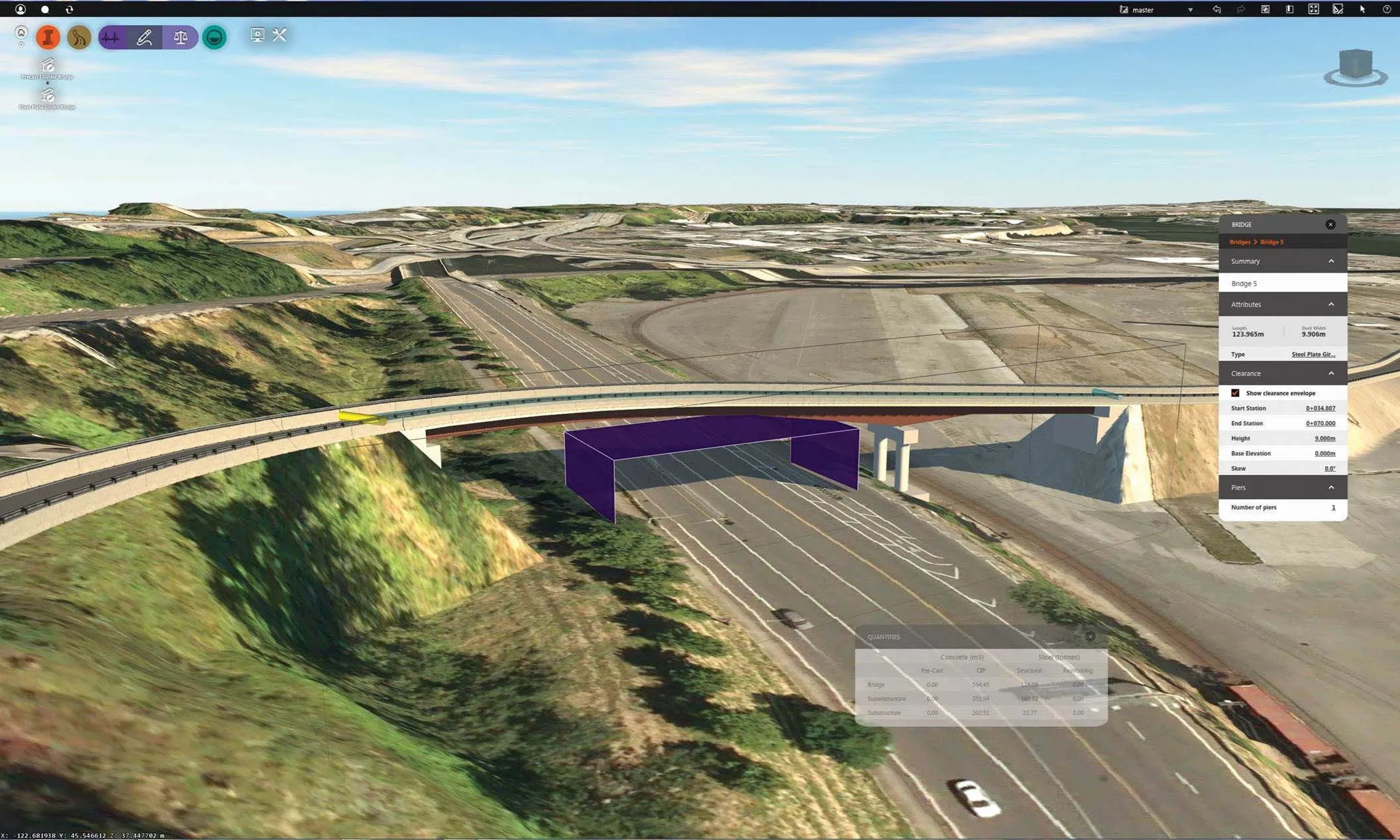
One place it could re-emerge is as a module for traffic representation in the rapidly developing InfraWorks, which has gone from a relatively simple sketch-out tool in its first Infrastructure  Modeler incarnation, to a major conceptual design tool.

The tool allows engineers to quickly explore ideas halfway towards detail design with finishing to detail level in a program like Autodesk Civil 3D. New versions are coming out quarterly at present and the latest has added to the specialist modules available. These include a road design module launched last year and now one for bridges which will drop a concrete or steel bridge into place in the 3D model with a few simple clicks.

Two new capacities in "preview mode" are available, one a new module, for drainage analysis  which in its initial form will calculate catchment areas and also create road culverts for water courses across proposed road routes. Calculation is done in the cloud so an internet connection is needed.

The other is a development of the road module now allowing it to optimise horizontal alignments as well as vertical alignment, working according to input parameters and landscape features.

Overall, the aim is to achieve a very intuitive and simple to learn software, according to Strongitharm, to give users the capacity to quickly draw up 'what if" and planning scenarios. A major element this time is a new interface.

"The new release looks very different," he said, "and the appearance is now based on games technology, our own Scaleform, which is used in computer and console games. It gives greater flexibility to really enhance the 'in context' options and design parameters to the user.

For more information on companies in this article

Related Content

  • Topcon announces increased 3D scanning integration with Autodesk
    August 17, 2015
    Topcon Positioning Group says it has improved workflow compatibility for the GLS-2000 3D laser scanner and ScanMaster software with Autodesk solutions. With the latest version of Autodesk ReCap, the GLS-2000 pairs with Topcon ScanMaster software to collect, process, edit and deliver 3D point cloud data from a laser scanner. ReCap allows users to perform tasks such as scan conversion, editing and viewing point cloud data. It also provides integration with Autodesk’s portfolio of design software. Aut
  • Keysoft Solutions buys LANDCADD rights from Eagle Point
    August 17, 2015
    Landscape and traffic software developer Keysoft Solutions has acquired the rights to LANDCADD software from US-based Eagle Point Software. Jeremy Ellis, managing director of Keysoft Solutions, said both the KeySCAPE and LANDCADD suite of landscape and civil design software will continue as separate products for time being. During a three-month plan, LANDCADD customers will continue to receive technical support from Eagle Point, while Keysoft Solutions builds up a sales and support team in Boston.
  • Bentley Systems launches OpenRoads Designer CONNECT Edition
    April 13, 2017
    The beginning of this year saw Bentley Systems launch a major advanced comprehensive global tool for today’s increasingly widespread BIM environment. Christmas 2016 came early for Bentley's global clients. In fact, they had a hint of what was going to be under their tree come the celebrations in December. On November 1, at Bentley’s annual global client gathering and awards event Year in Infrastructure Conference in London, the solutions provider announced that OpenRoads Designer CONNECT Edition would be a
  • Software tools aid construction, reduce costs
    February 28, 2012
    Integrated construction software offers an effective planning solution - *Mark Nichols writes. In a world where resources are limited, 20 year designing and building in a sustainable way is more critical than ever. By employing today's software tools it is possible to reduce the total cost of construction of a new highway, while reducing operating costs and environmental impacts. The path to achieving the greatest gains is to take a holistic approach to the plan, design, construct and operate process from t