Accurate surveys

Leica Geosystems says that its new Viva TS12 performance robotic package offers a comprehensive package of surveying solutions.
February 21, 2012 Read time: 1 min
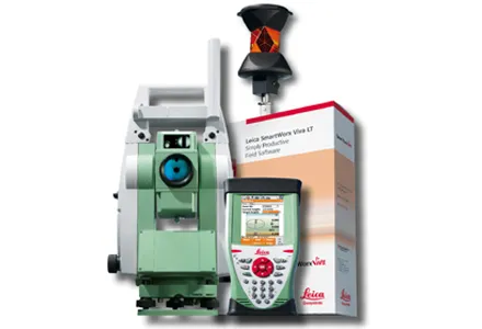
265 Leica Geosystems says that its new Viva TS12 performance robotic package offers a comprehensive package of surveying solutions. High accuracy surveying can be achieved using this cost-effective system, according to the firm. The package comprises the Leica Viva TS12 Total Station, the Viva CS10 Controller and the easy-to-use SmartWorx Viva Onboard Software. The Viva TS12 can be used to find, lock and measure points to prisms with accuracy. The PowerSearch sensor is said to locate any prism type within seconds, regardless of location. The Viva CS10 is said to be ergonomic in design and light in weight, allowing long range, secure and fast wireless connectivity to the Viva TS12. Meanwhile the SmartWorx Viva LT is designed using clear graphics, non-technical terminology and simplified workflows and is said to allow users to complete surveying tasks within a minimum of time.
For more information on companies in this article

Related Content

  • Innovative GIS advances from Bluesky
    July 18, 2012
    Aerial survey specialist Bluesky is funding research into the development and use of a new system to map the UK’s cities and towns at night. Bluesky has teamed up with the University of Leicester to look at solutions using new high sensitivity camera sensor technology. Mounted on survey aircraft, the new system can record the location of street lights, illuminated road signs and other night-time sources of light. This can deliver an accurate resource for asset inventories, light pollution assessment and ene
  • Control versatility
    July 2, 2012
    Leica Geosystems says that its CI-14 CAT Interface Module cuts installation time when fitting its 2D & 3D machine control systems to Caterpillar off-highway machines. Using the CI-14 package is said to eliminate the cost and effort of installing add-on hydraulic valves when fitting control tools from Leica Geosystems to Caterpillar K and T Series dozers and M Series graders. The CI-14 system can be used in conjunction with laser, slope, ultrasonic or 3D GPS/GNSS as well as the Leica PowerTracker total stati
  • Information integration
    February 17, 2012
    The sophisticated Leica MobileMatriX 4.1 package provides a key tool for integrating the new Leica Viva Total Stations with other technologies. Highly sophisticated, the Leica MobileMatriX package is said to be the most advanced solution available for mobile GIS applications. The system can be used in combination with GNSS, Total Stations, Level, Digital Cameras, and Laser Range Finders (LRF). Using the imaging support of the new TS15 and TS11, users of the Leica MobileMatriX package can take an image with
  • Sophisticated slipformer control from Wirtgen
    August 10, 2018
    Wirtgen is now offering a new version of its concrete slipformer control package. This new tool offers additional capabilities and improved performance over the earlier version. The company claims that its upgraded Wirtgen AutoPilot 2.0 package can deliver a higher paving accuracy along with lower costs. Newly-developed, this package is said to produce a wide array of offset and inset profiles, while also delivering these more economically and precisely than with the previous version. The 3D system can eit