Accurate surveys

Leica Geosystems says that its new Viva TS12 performance robotic package offers a comprehensive package of surveying solutions.
February 21, 2012 Read time: 1 min
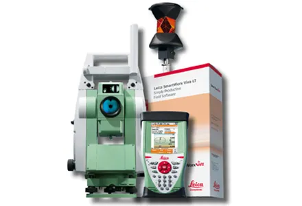
265 Leica Geosystems says that its new Viva TS12 performance robotic package offers a comprehensive package of surveying solutions. High accuracy surveying can be achieved using this cost-effective system, according to the firm. The package comprises the Leica Viva TS12 Total Station, the Viva CS10 Controller and the easy-to-use SmartWorx Viva Onboard Software. The Viva TS12 can be used to find, lock and measure points to prisms with accuracy. The PowerSearch sensor is said to locate any prism type within seconds, regardless of location. The Viva CS10 is said to be ergonomic in design and light in weight, allowing long range, secure and fast wireless connectivity to the Viva TS12. Meanwhile the SmartWorx Viva LT is designed using clear graphics, non-technical terminology and simplified workflows and is said to allow users to complete surveying tasks within a minimum of time.
For more information on companies in this article

Related Content

  • Leica Vivo portfolio expansion
    February 18, 2013
    Leica Geosystems has expanded its Leica Viva portfolio with the Leica Viva GS14, said to be an exceptional and deployment versatile GNSS receiver. The Viva GS14 has a compact design with integrated communication devices. Along with the dependable GNSS RTK, the Viva GS14 is said to deliver complete confidence and knowledge in results. Useable as a robust yet lightweight rover and as a base station, Leica’s new GNSS receiver allows users to gain speed and efficiency by reducing the number of setups and contro
  • New solutions for 3D concrete paving controls
    February 20, 2012
    In concrete paving, Leica Geosystems has long held the dominant position in the market for stringless 3D controls. The company's products are well-accepted by contractors and have been used on an array of machines from different manufacturers with a high degree of success in recent years. GOMACO has been working with Leica Geosystems for some time and the two companies set up a partnership recently. This combination technology and business relationship has seen the placement of personnel from Leica Geosyste
  • Data collection key to software developments
    February 13, 2012
    The collection and handling of data are key technology drivers in the software sector. New methods of data collection and manipulation are driving significant developments in software at present. The latest technology allows designers and engineers to collect, store and manipulate ever larger amounts of data. Growing use of mobile field equipment for both data collection and field management is driving interactive systems. And in an interview this month Autodesk senior vice-president for the construction an
  • Sophisticated scanning tool from Leica Geosystems
    November 8, 2017
    A new laser scanning tool from Leica Geosystems offers accurate and fast 3D imaging laser scanning capabilities. The Leica BLK360 is said to be compact and easy to use, offering powerful spherical image capture duties. The firm says that the unit allows professionals to capture 360° imagery within minutes.