
Trimble’s new drone package offers versatility

Trimble is now offering a sophisticated new drone package called Trimble Stratus, through the firm’s partnership with drone-mapping and analytics company Propeller Aero. According to Martin Wagener, worldwide product implementation manager for the firm, the system allows the user to employ any type of commercial quality drone. The important part of the package is the Aeropoint, a small flat plate developed by Propellor. This is placed on the ground and acts as a point of reference for all of the drone’s ge
April 26, 2018 Read time: 2 mins
Trimble’s new drone offering can deliver accuracy and versatility
2122 Trimble is now offering a sophisticated new drone package called Trimble Stratus, through the firm’s partnership with drone-mapping and analytics company 8779 Propeller Aero. According to Martin Wagener, worldwide product implementation manager for the firm, the system allows the user to employ any type of commercial quality drone.


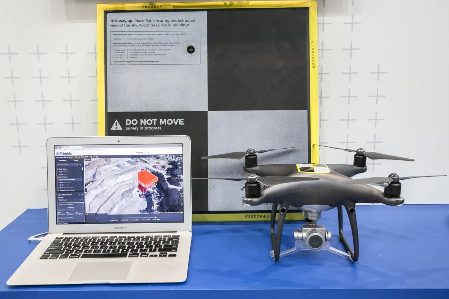
The important part of the package is the Aeropoint AeroPoint, a small flat plate ground control point developed by Propeller Aero that makes drone data survey-grade and works with any GPS enabled device. This is placed on the ground and acts as a point of reference for all of the drone’s geolocated images and measurements. The plate features integral GPS and wireless connectivity.
 
The package allows a user to get a comprehensive overview of a project or working area. “You upload all of the pics onto the online Trimble Stratus package and it stitches all the images together to form a digital terrain model. A few hours later you get full pointcloud models from Trimble,” said Wagener.
 
Wagener explained that it requires minimal training to operate, with the complex image data handling task offered as a service by Trimble Trimble Stratus, or its SiTech SITECH dealer network, for the customer.

For more information on companies in this article

Related Content

  • Rapid adoption of GPS machine control
    April 5, 2012
    The high sophistication of GPS machine control systems has resulted in a fast pace of technological advancement. The three major players in the machine control sector, Leica Geosystems, Topcon and Trimble have all made major gains in recent years. The sophistication of the latest systems can combine satellite position data from the GPS and GLONASS networks with information from total stations to provide precise, high speed machine operation. Further more the firms have also prepared themselves for the intro
  • Trimble’s vision of a far more efficient future
    July 5, 2021
    Trimble is offering a future with more efficient, optimised construction operations for faster project delivery
  • Compact machine control package from trimble
    December 10, 2018
    Trimble is introducing the Earthworks GO! package, aimed at use with compact machines. This is a significant development as it will allow users of small machines access to machine control systems, improving productivity and work quality. The firm says that its Earthworks GO! offering allows users to deliver accurate grading with a simple, portable package. This compact machine control solution runs on Android or iOS smartphones. Scott Crozier is general manager of Trimble’s general construction division. H
  • Airware acquires drone data analytics provider Redbird
    September 23, 2016
    Airware, a commercial drone solutions provider, has acquired Redbird, a France-based pioneer in drone data analytics that has been working closely with Caterpillar. Redbird focuses on the mining, quarrying, and construction industries through sophisticated geospatial analytics which will be integrated into the Airware Aerial Information Platform. This will give customers the combined power of Redbird's industry-specific analytics and Airware's enterprise-focused workflow, compliance, and security feature