Topcon unveils Hybrid Robotic System

Topcon Positioning Group has unveiled its Hybrid Robotic System, featuring the new DS series robotic total station and the recently announced MAGNET v2.0 software suite, a Topcon enterprise solution for the geomatics industry. Other Topcon components in the cutting-edge HRS include the economical HiPer SR GNSS receiver and Tesla large-screen tablet controller. The new system combines GNSS positioning and robotic measurements with an automated data workflow to provide added versatility and efficiency for
January 21, 2014 Read time: 2 mins
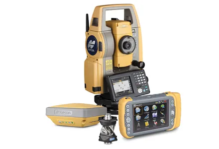
342 Topcon Positioning Group has unveiled its Hybrid Robotic System, featuring the new DS series robotic total station and the recently announced MAGNET v2.0 software suite, a Topcon enterprise solution for the geomatics industry.

Other Topcon components in the cutting-edge HRS include the economical HiPer SR GNSS receiver and 4071 Tesla large-screen tablet controller.

The new system combines GNSS positioning and robotic measurements with an automated data workflow to provide added versatility and efficiency for any measurement or layout job, regardless of job site conditions.

“Topcon’s Hybrid Positioning technology is an innovative and highly productive system that creates an integrated GNSS-robotic rover,” said Scott Langbein, director of product marketing for 7300 Topcon Positioning Systems (TPS).

“The DS robotic total station provides precise measurements anywhere the prism can be seen. When the rover is out of line of sight, GNSS positioning takes over by simply pressing MAGNET’s Hybrid Switch button on the controller,” said Langbein.

“With this versatile system, you can auto-track the prism, use network or an RTK connection,” he said. The system also utilises LongLink communications technology with the HiPer SR, which provides a wireless connection for data transfer, but “with an RTK solution for the HiPer SR, the system performs at maximum versatility on any size job,” added Langbein. If a network RTK solution is not available, using MAGNET Relay, a user can set up an individualised, mobile reference RTK base.

With MAGNET providing the link, the field and office can be connected to exchange files, receive and send messages from crews, and compile and send measurement data to the office.

Hybrid Positioning technology is compatible with other robotic instruments, including the Topcon PS, IS, QS, and Sokkia SX, as well as other GNSS receivers including the Topcon HiPer V, GR-5 (Vanguard), GRS-1 and the Sokkia GRX.

For more information on companies in this article

Related Content

  • Key technology moves for Leica Geosystems
    July 9, 2024
    Leica Geosystems is developing its product offerings with key moves.
  • Cat’s wider range
    May 20, 2019
    Caterpillar is offering new machine control packages for use with dozers Caterpillar is widening its range of solutions for dozers with the introduction of the GRADE with 3D system for its D3K2, D4K2 and D5K2 models. This package is an automated grade control system using GNSS technology to position the machine's blade, without operator input, from first rough cut to finish grade. In addition, GRADE with 3D incorporates the Cat AccuGrade Ready Option. This system allows the use of universal-total-stati
  • Bentley’s point cloud innovation for information modelling in road design
    August 22, 2013
    Latest software packages from Bentley Systems will help optimise project design and construction efficiency – Mike Woof reports Software systems have come a long way in helping optimise construction projects from design through construction to delivery. And the latest software from Bentley Systems offers additional capabilities for road design applications. Bentley Systems is offering the V8i (SELECTseries 3) versions of its InRoads, GEOPAK, and MXROAD products. All of the products now share the
  • Trimble offers advanced dozer machine control solution
    February 28, 2018
    Trimble is now introducing its Earthworks for Dozers package, following on from the Earthworks for Excavators system unveiled last year. The Earthworks Grade Control System for Dozers uses the same inertial motion sensors (IMUs) as the excavator package and mounts its dual GNSS receivers on top of the cab to eliminate masts and cables conventionally located on the blade. The dual GNSS receivers suit steep slope work and complex designs with tight tolerances. The new configuration keeps valuable receivers