Topcon Positioning Group has unveiled its Hybrid Robotic System, featuring the new DS series robotic total station and the recently announced MAGNET v2.0 software suite, a Topcon enterprise solution for the geomatics industry.
Other Topcon components in the cutting-edge HRS include the economical HiPer SR GNSS receiver and Tesla large-screen tablet controller.
The new system combines GNSS positioning and robotic measurements with an automated data workflow to provide added versatility and efficiency for
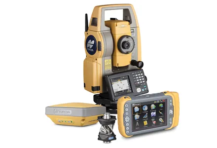
Other Topcon components in the cutting-edge HRS include the economical HiPer SR GNSS receiver and
The new system combines GNSS positioning and robotic measurements with an automated data workflow to provide added versatility and efficiency for any measurement or layout job, regardless of job site conditions.
“Topcon’s Hybrid Positioning technology is an innovative and highly productive system that creates an integrated GNSS-robotic rover,” said Scott Langbein, director of product marketing for
“The DS robotic total station provides precise measurements anywhere the prism can be seen. When the rover is out of line of sight, GNSS positioning takes over by simply pressing MAGNET’s Hybrid Switch button on the controller,” said Langbein.
“With this versatile system, you can auto-track the prism, use network or an RTK connection,” he said. The system also utilises LongLink communications technology with the HiPer SR, which provides a wireless connection for data transfer, but “with an RTK solution for the HiPer SR, the system performs at maximum versatility on any size job,” added Langbein. If a network RTK solution is not available, using MAGNET Relay, a user can set up an individualised, mobile reference RTK base.
With MAGNET providing the link, the field and office can be connected to exchange files, receive and send messages from crews, and compile and send measurement data to the office.
Hybrid Positioning technology is compatible with other robotic instruments, including the Topcon PS, IS, QS, and Sokkia SX, as well as other GNSS receivers including the Topcon HiPer V, GR-5 (Vanguard), GRS-1 and the Sokkia GRX.