Remote surveying and scanning

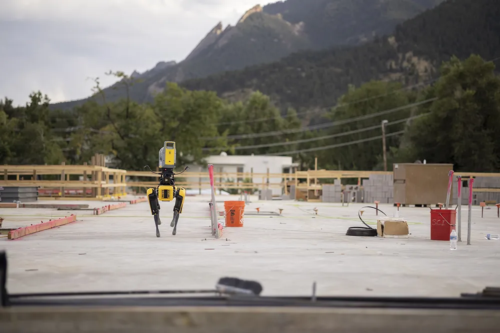
Remote surveying and scanning can be achieved using the autonomous robotic system available from Trimble. The package combines the Spot robot autonomous rover unit with the Trimble X7 3D laser scanner and Trimble FieldLink software.
January 18, 2022 Read time: 2 mins
Autonomous surveying and scanning is possible using the new package from Trimble

This solution has been jointly developed between Trimble and Boston Dynamics and allows autonomous operation on construction sites. The system takes advantage of the robot's ability to navigate challenging, dynamic and potentially unsafe environments. Trimble's 3D data capture technology can deliver a continuous flow of information between the field and the office for documentation of jobsite progress.

The innovative package allows users to make important decisions, rather than waiting for the information to be relayed to project staff. The integration is focused on the automated capture of field construction data through the use of Trimble 3D capture technology and the Spot robot. The autonomous workflow for the X7 laser scanner uses fully integrated Spot robot controls in FieldLink software to create a predefined path of waypoints for Spot to follow and collect laser scans.

Laser scans collected using the X7 scanner and the Spot robot can be tied to a jobsite project coordinate system, as well as individual scan stations. The data is collected, and then made into a composite point cloud in real-time on the Trimble tablet controller before leaving the site. While performing autonomous operations, Spot's docking station enables in-field charging of batteries on both the robot and the X7 3D laser scanner, and also provides the continuous transfer of data through a Gigabit Ethernet connection to the office.

For more information on companies in this article

Related Content

  • Heijmans’ bright yellow Dynapacs get the green light at Schiphol
    August 5, 2016
    A damp and foggy morning at Amsterdam’s Schiphol Airport in the Netherlands. Some of the five runways are in normal use, but one of them shows a different kind of activity. At a slow but steady pace, a small army of bright yellow machines is repaving the surface. The project is being carried out by Heijmans, one of the largest road-building contractors in the Netherlands.
  • Traffic management software tools
    March 5, 2012
    A joint development project between Delcan Corporation and Intelligent Devices Incorporated (IDI) has resulted in the sophisticated Intelligent NETworks product. This is an integrated product that combines the IDI Intelligent Control NTCIP system with the Delcan advanced transportation applications of NETworks. The system can be linked to dynamic message signs (DMS), CCTV and vehicle detector stations (VDS), traffic intersections, as well as environment road weather sensor stations.
  • All change – the evolution of data
    October 13, 2017
    Bentley Systems believes that it is on the cusp of a revolutionary step in computing that will boost the working efficiency of companies right across industry. Bhupinder Singh, chief products officer at Bentley Systems explained that its key advance will allow firms to utilise what they already have, but more efficiently.
  • BOMAG’s smart asphalt compaction technology in use
    May 25, 2016
    BOMAG’s highly sophisticated compaction control technology is now being used successfully on the highway project to link Warsaw with St Petersburg. The system is being employed in the rural area around the border triangle of Lithuania, Latvia and Belarus. Lithuanian road contractor Panevezio Keliai won the package of works to upgrade a stretch of the E262 in Zarasai. The project requires high quality as the E262 route links Warsaw with St Petersburg and carries a large volume of traffic, including a hig