Novel survey solution from Hexagon

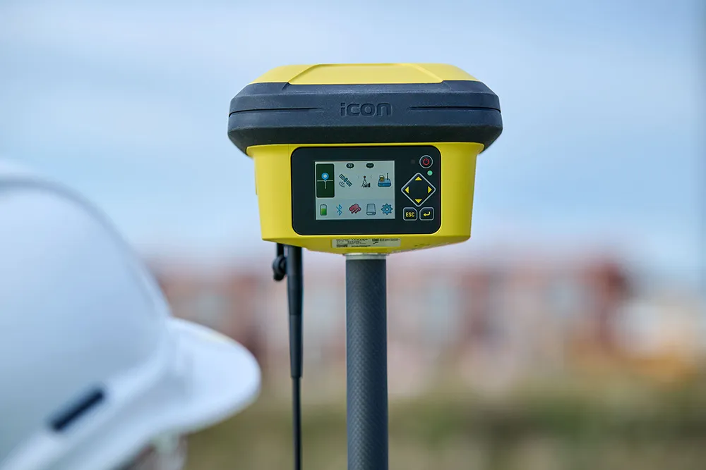
Leica Geosystems, part of Hexagon, says that its Leica iCON gps 160 package is a next-generation construction Smart Antenna with features that increase productivity for stakeout and measurement applications on the jobsite.
January 6, 2023 Read time: 2 mins
Leica iCON gps

The Leica iCON construction portfolio offers a broad range of Smart Antennas to suit all applications according to the firm. The Smart Antennas are said to be able to withstand challenging site conditions. The units integrate with all Leica iCON construction instruments and controllers as well as the iCON field software for precise, real-time verification.

The iCon gps 160 is a versatile solution for various applications. It can be used as a base station, a rover or for machine guidance. The Leica iCON gps 160 is an improved version of the successful Leica iCON gps 60. The result is a smaller, more compact GNSS antenna with additional features and a larger display for ease of use.

Leica Geosystems introduced its safety awareness solution portfolio, including Leica iCON PA10, iCON PA80 and iCON CAS, which addresses the need to immediately warn on- and off-machine field personnel of potential machine-to-people, machine-to-machine and machine-to-object and collisions. As the next step, the company integrates the field-generated safety data into the cloud-based collaboration platform Leica ConX, allowing decision-makers to review incidents and assess the entire operation over time and space. These insights support important safety initiatives by providing visualisation, analysis, monitoring, reporting and data management functions, and address communication and integration needs.

To expand its portfolio of Smart Antennas, Leica Geosystems has launched the iCON gps 160, a versatile solution for various applications. It can be utilised as a base station, a rover or for machine guidance. The Leica iCON gps 160 is a modernisation and enhancement of the successful Leica iCON gps 60, which has been well accepted in the market. The result is a smaller, more compact GNSS antenna with additional features and a larger display for ease of use.

For more information on companies in this article

Related Content

  • Construction software boosts operating efficiency
    March 5, 2012
    Intelligent data handling and management technologies are helping boost operating efficiency - Mike Woof reports The construction software sector and GIS market are seeing a rapid development of new products and technologies that will help boost efficiency, with factors such as data management and platform integration being key focus areas.
  • New technology solutions
    April 30, 2024
    Construction machinery manufacturers are introducing new systems that can boost machine efficiency and site safety – Mike Woof writes
  • Intermat innovation for machine control systems
    June 23, 2015
    Improving technologies for machine control systems continue to deliver increases in efficiency for contractors - Mike Woof writes Machine control technologies have continued to develop as the specialist suppliers in this fiercely fought sector seek to find a competitive advantage over their rivals. The key players, Leica Geosystems, MOBA, Topcon and Trimble, have all been pushing the boundaries with their latest technologies. Although the systems these firms are introducing are aimed at a number of differen
  • Leica Captivate Experience works with fifth generation of ATRplus
    August 17, 2015
    Leica Geosystems says its Leica Captivate Experience creates highly realistic 3D models that enables professionals to capture and manage complex data easily and accurately. With little more than a swipe, users can now navigate through customisable apps containing information for multiple projects. Advanced lining and coding provide an interactive 3D model where users can zoom, pan and orbit the rendering for optimal viewing and manipulation. “Leica Geosystems has taken a giant leap forward with Captiv