High performance from Topcon’s HiPer XR

April 11, 2025 Read time: 1 min
The lightweight HiPer XR, from Topcon Positioning Systems, Dynamic TILT Compensation technology for effortless measurements, even in difficult conditions

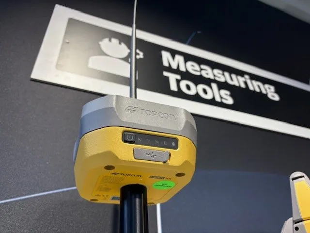
The HiPer XR, from Topcon Positioning Systems, is a robust high-precision GNSS receiver for surveying, construction and geospatial work. It delivers precision and efficiency, tackling all challenges with RTK accuracy and Dynamic TILT Compensation technology for effortless measurements, even in difficult conditions.

Its anti-jamming capabilities ensure reliable performance, while the lightweight, rugged design withstands harsh environments. The HiPer XR is about versatile connectivity with long battery life at an affordable price.

Its multi-constellation support delivers improved accuracy by tracking multiple satellite systems simultaneously, ensuring reliable data even in challenging conditions. With fast charging that reaches 50% in just 30 minutes, downtime is minimised.

TILT technology enables accurate pole-tip measurements without the need for calibration and is also resistant to magnetic interference. Its advanced anti-jamming capabilities ensure reliable signal performance, even in demanding environments.  

Designed to be both durable and lightweight – just under 1kg - it can endure tough conditions while remaining easy to handle.

With support for multiple constellations, flexible connectivity options, and a cost-effective design, the HiPer XR is a practical and adaptable solution for modern surveying needs. 

For more information on companies in this article

Related Content

  • Rapid adoption of GPS machine control
    April 5, 2012
    The high sophistication of GPS machine control systems has resulted in a fast pace of technological advancement. The three major players in the machine control sector, Leica Geosystems, Topcon and Trimble have all made major gains in recent years. The sophistication of the latest systems can combine satellite position data from the GPS and GLONASS networks with information from total stations to provide precise, high speed machine operation. Further more the firms have also prepared themselves for the intro
  • New tablet solution for Leica Geosystems
    December 12, 2018
    Leica Geosystems is now using the rugged ZX70 Android tablet from Getac as the hardware for its new Leica Zeno GG04 plus Tablet Solution. The new partnership allows Leica Geosystems to bring geospatial data collection capabilities to customers in all terrains and weather conditions such as utilities, public services, transportation and construction. Leica Geosystems has developed a range of new software and hardware including its Zeno Mobile data collection app and Zeno GG04 plus smart antenna to capture a
  • Free modeling: Improving efficiency in construction- site management
    July 24, 2025
    Liebherr’s innovative Free Modeling technology enables road-construction operators to create and modify simple 3D site models directly from their machinery, enhancing real-time decision-making.
  • Sophisticated geopositioning tool from Topcon
    October 9, 2018
    Topcon says that its new T-18 handheld controller offers accuracy for geopositioning, construction, mapping and vertical construction applications. The controller includes a sunlight-readable display with a 1GHz processor, 1GB of internal storage, and up to 10 hours of battery life. “For MAGNET Field data collection, the T-18 controller offers a durable ergonomic solution with faster processing, a larger screen, better connectivity and longer battery life than previously available comparable systems,” said