
Handheld imaging from Leica Geosystems

Leica Geosystems is offering an updated imaging tool in the shape of its latest BLK3D model.
May 21, 2021 Read time: 1 min

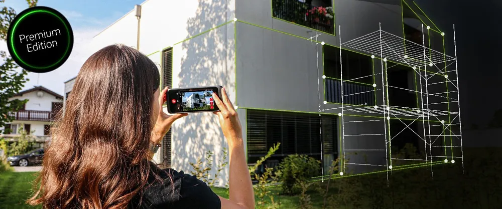
The firm says that its new handheld imager now offers twice the operating range of the previous variant. In-picture measurement accuracy has also been improved for indoor and outdoor applications.

Users benefit from new guidance and accuracy indication features that allow them to optimise the capturing process to achieve high measurement accuracy. This is achieved by significantly enhancing BLK3D image processing algorithms alongside workflow adaptation which allows for capturing multi-shots with up to four shots. The BLK3D Update is rolled out with the new BLK3D Mobile and Desktop software version 3.0. BLK3D with Publisher license enables collaboration amongst teams, providing accessibility to 3D images using the cloud. Measurements can be created and shared on mobile devices such as smartphones and tablets across project teams.

The firm says that it designed BLK3D mobile and desktop 3.0 for users starting their journey into digitalisation and digital experts that have already been working in the area for some time. The unit provides increased accuracy, longer range and added functionality, allowing users to make their work more efficient, effective and productive according to the company.

For more information on companies in this article

Related Content

  • Improved laser scanning capabilities
    February 23, 2012
    Leica Geosystems is broadening its software offering with its new Leica Cyclone v7.2 package, which is said to improve office processing capabilities. The package has been developed to address key market needs and trends in the processing and use of rich, as-built point cloud data from high definition laser scanning technology. According to the firm the package can help reduce laser scanning project costs, including office time, allowing projects to use more scans and higher scan densities.
  • Developments in site survey solutions
    February 9, 2012
    Trimble is widening its portfolio of Connected Site survey solutions for the field and office. These upgraded tools allow surveyors to collect, share and deliver data faster to improve accuracy, efficiency and productivity.
  • Digital transformation is delivering digital adoption
    August 15, 2023
    Digital transformation is key for transportation agencies and their partners to do their jobs better and faster. One way to do this is through digital delivery using digital models, data, and supporting field tools for roadway design, structures design, and construction, say the tech experts at Bentley Systems.
  • Ma-estro turns quarry operators into skilled Q-PILOTS
    July 3, 2023
    As the adoption of artificial intelligence-based technology sweeps across various industrial sectors, concerns have surfaced about the potential displacement of human labour and professional expertise. In response, Ma-estro is championing AI-driven innovation as a means of bucking the trend, placing people back at the core of the quarrying sector with tools designed to enhance and improve human labour rather than supplant it.