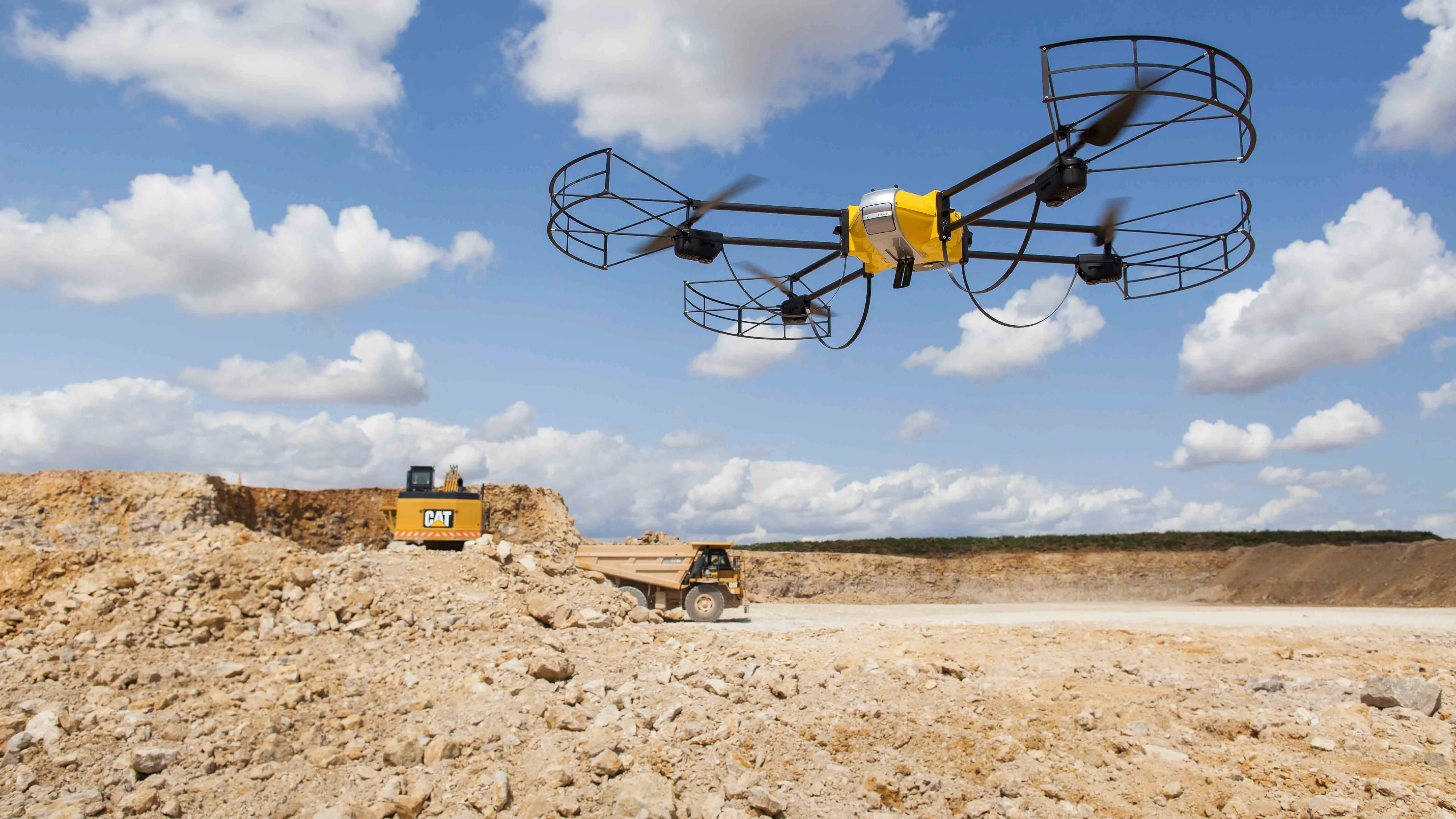
Airware, a commercial drone solutions provider, has acquired Redbird, a France-based pioneer in drone data analytics that has been working closely with Caterpillar.
Redbird focuses on the mining, quarrying, and construction industries through sophisticated geospatial analytics which will be integrated into the Airware Aerial Information Platform. This will give customers the combined power of Redbird's industry-specific analytics and Airware's enterprise-focused workflow, compliance, and security feature
Airware, a commercial drone solutions provider, has acquired Redbird, a France-based pioneer in drone data analytics that has been working closely with 178 Caterpillar.
Redbird focuses on the mining, quarrying, and construction industries through sophisticated geospatial analytics which will be integrated into the Airware Aerial Information Platform. This will give customers the combined power of Redbird's industry-specific analytics and Airware's enterprise-focused workflow, compliance, and security features, according to a joint statement.
“Commercial drone technology brings these operations into the digital world while offering faster, cheaper and higher-quality data and analytics,” said Jonathan Downey, founder and chief executive of Airware.
Customers can plan drone flights, capture high-quality aerial data, analyse it and create detailed, survey-grade mining and construction site maps of more than 400 hectares a day, per drone, for immediate and exact production tracking and site safety assessment.
“Building materials companies and contractors are no longer experimenting with drones, but are looking to put drones to work for their businesses,” said Emmanuel de Maistre, co-founder and chief executive of Redbird.
Redbird was founded in 2013 and Airware was established in 2011. Redbird’s Paris office will become Airware’s European headquarters.
In May, Caterpillar and Redbird expanded the geographic scope of their collaboration. Redbird’s data analysis and reporting tools are now offered to Caterpillar customers worldwide instead of only in Europe, Africa and the Middle East, said George Taylor, vice president for digital at Caterpillar.
Last March, de Maistre %$Linker:2 Internal <?xml version="1.0" encoding="utf-16"?><dictionary /> 2 26100 0 oLinkExternal told World Highways Visit WH Page false /categories/measurement-survey-design-software/features/caterpillar-has-a-vision-that-includes-total-project-site-overview/ false false %> how it was working with Caterpillar to help the machine manufacturer move towards more so-called project site overview. The Holy Grail is to integrate machine equipment information with 3D site information. De Maistre calls it “Google Map for quarries or construction sites”.
In 2014, Redbird partnered with Bergerat Monnoyeur, Caterpillar’s exclusive dealer in France and several other countries, including Belgium and Poland. The objective was to develop specific data analytics for Bergerat’s customers. But Redbird is not a drone maker, nor usually a drone operator. It provides a service only through its advanced cloud platform called Cardinal, named after a common small North American bird. No specific software is required, only internet access and a login.
Redbird focuses on the mining, quarrying, and construction industries through sophisticated geospatial analytics which will be integrated into the Airware Aerial Information Platform. This will give customers the combined power of Redbird's industry-specific analytics and Airware's enterprise-focused workflow, compliance, and security features, according to a joint statement.
“Commercial drone technology brings these operations into the digital world while offering faster, cheaper and higher-quality data and analytics,” said Jonathan Downey, founder and chief executive of Airware.
Customers can plan drone flights, capture high-quality aerial data, analyse it and create detailed, survey-grade mining and construction site maps of more than 400 hectares a day, per drone, for immediate and exact production tracking and site safety assessment.
“Building materials companies and contractors are no longer experimenting with drones, but are looking to put drones to work for their businesses,” said Emmanuel de Maistre, co-founder and chief executive of Redbird.
Redbird was founded in 2013 and Airware was established in 2011. Redbird’s Paris office will become Airware’s European headquarters.
In May, Caterpillar and Redbird expanded the geographic scope of their collaboration. Redbird’s data analysis and reporting tools are now offered to Caterpillar customers worldwide instead of only in Europe, Africa and the Middle East, said George Taylor, vice president for digital at Caterpillar.
Last March, de Maistre %$Linker:
In 2014, Redbird partnered with Bergerat Monnoyeur, Caterpillar’s exclusive dealer in France and several other countries, including Belgium and Poland. The objective was to develop specific data analytics for Bergerat’s customers. But Redbird is not a drone maker, nor usually a drone operator. It provides a service only through its advanced cloud platform called Cardinal, named after a common small North American bird. No specific software is required, only internet access and a login.