XenomatiX launches XenoTrack Dual Lane

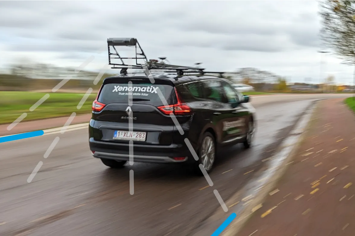
XenoTrack Dual Lane surveys two neighbouring lanes in a single pass while the survey vehicle drives in one lane.
By David Arminas March 6, 2023 Read time: 2 mins
Two lanes better than one: the XenoTrack Dual Lane system is set up in no time and the measurement vehicle can drive faster than 70kph

The latest version of XenomatiX’s road lidar XenoTrack inspection system covers two lanes in one pass.

XenoTrack Dual Lane was officially launched this month at GeoWeek, a major event for the geospatial and 3D sector that took place in the US city of Denver.
 
XenomatiX, a solid state lidar company specialising in road asset management and digital twins of roads, launched the XenoTrack Single Lane system last year. Now, the company says that with the Dual Lane system, it “took a step-in easing 3D pavement measurement”.

Traditional road assessment systems are limited to measuring the width of one or part of a road lane on each pass. But XenoTrack Dual Lane surveys two neighbouring lanes in a single pass. While the vehicle drives in one lane, the system simultaneously measures the road surface condition of that lane and the neighbouring lane.

All XenoTrack products including the Dual Lane system, use a highly accurate lidar as main component, offering 3D and intensity maps of the road surface.

Additionally, 2D RGB camera images can complement the 6D Road Survey concept. The RGB colour model is an additive colour model in which the red, green and blue primary colours of light are combined to reproduce a broad array of colours. The name of the model comes from the initials of the three additive primary colours - red, green and blue.

Both the Single Lane and the Dual Lane systems fit on any standard vehicle, saving the customer having to invest in expensive and dedicated survey vehicles. The XenoTrack system is set up in no time and the measurement vehicle can drive faster than 70kph, further increasing the efficiency of the surveys.

XenomatiX’s solid state lidars are based on a multi-beam lasers concept and mature, scalable semiconductor technology. The company’s main product lines consist of XenoTrack and XenoLidar. XenoTrack collects and processes a wide range of data to enable applications like digitising the road, IRI (International Roughness Index), rutting analysis and more.

The company is based in Leuven, Belgium, and employs about 50 employees in Belgium, Germany, US and China with a distribution network around the world.

For more information on companies in this article

Related Content

  • IBI’s Routemapper charts new territory with Highways England
    September 14, 2016
    Mapping the asset High-speed data collection just got faster for England’s newly created strategic roads operator Highways England’s establishment as a publicly held company in 2015 created a need for a highly accurate asset inventory. This was potentially very costly and had serious safety implications. As well as its relationships with numerous managing agents and contractors, assets include 35,300km of highway, 12,100km of earthworks, 23,200km of safety fences, 150,000 technology assets and sig
  • Using radar to deliver a fine runway finish
    April 4, 2014
    Radar Portal Systems (RPS) has spent a lot of time developing its sophisticated pavement top-surface photometric imaging system so it can cater specifically for the aviation market. This has now been specially developed for use on aircraft runways and taxiways The system was recently used at Brisbane Airport to survey runway and runway shoulders, collecting photometric top-surface data at a 4m width at speeds of up to 100km/h. This dataset allows the firm to display meshing data of the runway surface showin
  • IRF & XenomatiX present course on next generation road scanning systems
    August 15, 2022
    On May 20, the International Road Federation concluded a one-week global benchmarking course on preventive management of road assets with a field overview of next-generation road scanning and survey systems.
  • SICK launches 3D TIC502 LiDAR sensor system for traffic management
    May 18, 2018
    Sick says that its latest TIC502 twin LiDAR sensor system has high all-weather capability between -40OC and +60OC. The TIC502 incorporates vehicle speed detection with 3D profiling and counting of fast-lane, free flowing and static traffic to facilitate toll charge assessment. It can also be integrated with additional 2D LiDAR sensors to count axles for complete traffic profiling and assessment in a single system, according to the company that was set up in 1946 by optical engineer Erwin Sick in Waldkir