
Get the real picture with Image Logger

RoadBotics has placed time-stamped geo-spatial images on GIS-enabled maps.
By David Arminas July 31, 2020 Read time: 2 mins
Image Logger, the first product in the company’s cloud-based RoadWay Operating System online platform

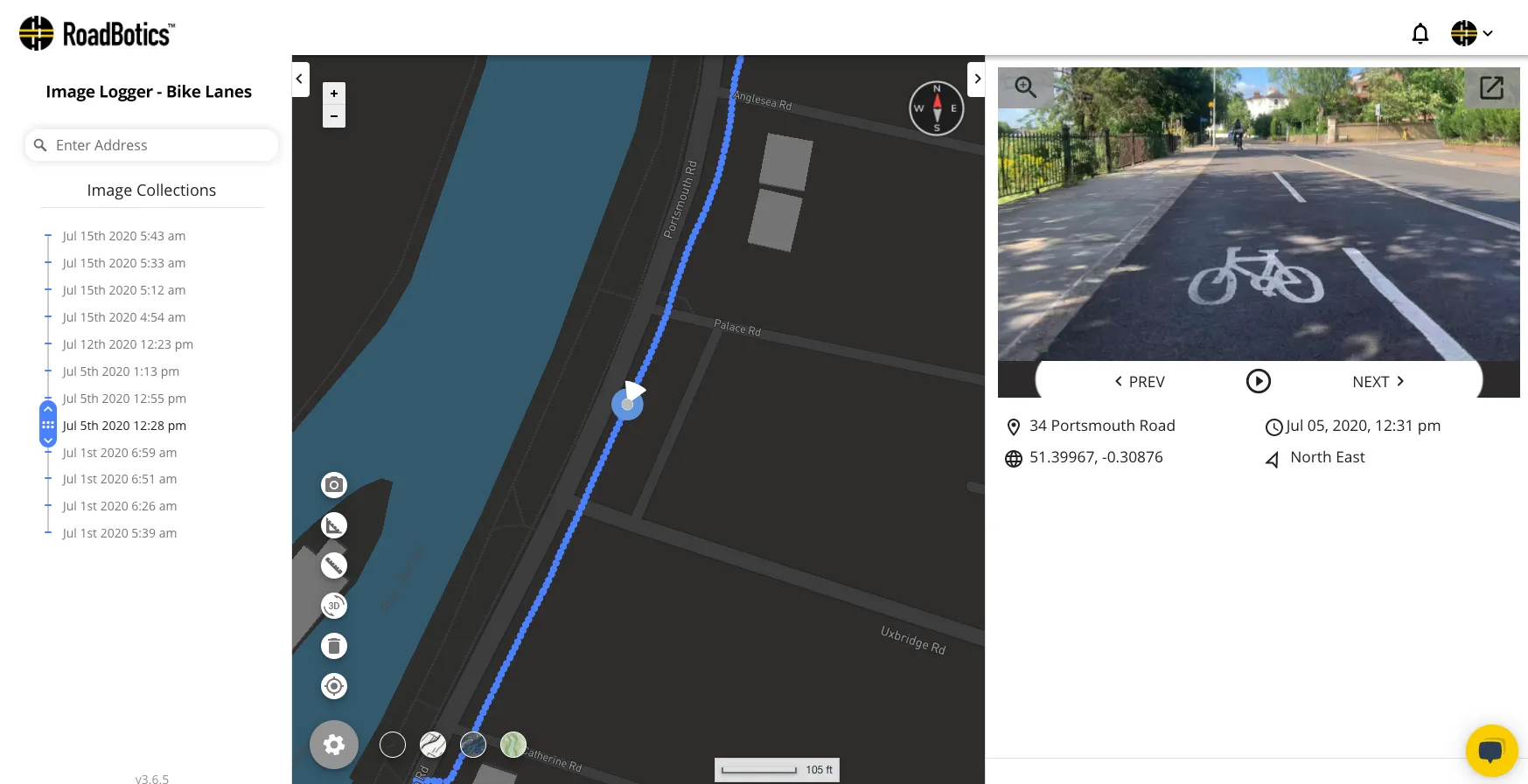
RoadBotics is announcing the addition of Image Logger to its growing suite of products to help communities digitise assets such as roads, sidewalks and trails.

The company, based in Pittsburgh in the US state of Pennsylvania, said the technology places time-stamped geo-spatial image data on a GIS-enabled map. The result allows local authorities to view all public assets on one platform - from a desk or out in the field.

“The Image Logger is a great addition to our existing products and tools for road and infrastructure management,” said Matt Lucas, head of product at Roadbotics. “It helps our clients to better administer their assets while saving valuable resources.”

RoadBotics - known for automated pavement assessments using a smartphone for data collection –users can collect data on roads and adjacent assets such as signage and public right of ways including sidewalks, bike trails and walking paths. Whether collected monthly, seasonally or before and after maintenance projects, up-to-date data is invaluable for asset management.

The Image Logger  was released in early June as the first product for the company’s new RoadWay Operating System, a cloud-based online platform. RoadWay OS helps governments manage and administer their public infrastructure asset data in one central location. “Image Logger accomplishes that objective by the ease of use and breadth of data available,” said Benjamin Schmidt, president and co-founder of RoadBotics.

Roadway OS is also available to outside consultants and professionals who help governments maintain infrastructure, whether this is managing tactical day-to-day operations or enhancing strategic planning.

Related Content

  • Canadian tower tops out on Gordie Howe
    December 21, 2023
    The six-lane cable-stayed bridge project includes new customs plazas in both Detroit and Windsor as well as a new link to the I-75 interstate highway in Detroit.
  • Transurban to test Melbourne drivers in road trials, including tolls
    June 23, 2015
    Melbourne’s road users are the focus of a year-long study into what options are possible for funding road infrastructure projects including various user-pays models. The study headed by Australian toll roads operator Transurban will conducted across Melbourne’s entire road network to see how drivers react to tolling and other road-use models such as charging motorists for each kilometre travelled, a charge to access roads, annual fixed costs per kilometre on expected usage and price per trip. It will al
  • Show me the money at Australian Summit
    September 4, 2012
    The question of how to finance and fund major road infrastructure projects in Australia – including the potential role of user-pays charging as a funding solution – was top of mind at the recent Roads Australia National Summit in Sydney. The two-day summit, organised by peak national body Roads Australia, is the largest and most influential annual gathering of industry decision-makers in the country. This year’s summit was held against a backdrop of concern over the future of a raft of major road projects t
  • Sripath and sustainable surfaces
    December 9, 2024
    Deepak Madan* explains how Sripath’s portfolio of products helps paving contractors achieve their sustainability goals.