Easy does it with GSSI’s PaveScan RDM 2.0

GSSI says that its PaveScan RDM 2.0, a non-destructive asphalt density assessment tool, is characterised by being easy to use, no matter what technical level the operator has.
By David Arminas February 27, 2023 Read time: 2 mins
By uncovering inconsistencies that occur during the paving process, including poor uniformity and significant variations in density, PaveScan RDM 2.0 helps to avoid premature failures

GSSI, a manufacturer of ground penetrating radar (GPR) equipment, says that from technician to engineer, the PaveScan RDM 2.0 testing system is easy to operate.

The PaveScan RDM 2.0 is a second-generation asphalt density assessment tool ideal for non-destructive asphalt compaction testing, quality assurance/quality control of new pavements and determining pavement non-conformity.

By uncovering inconsistencies that occur during the paving process, including poor uniformity and significant variations in density, PaveScan RDM 2.0 helps to avoid premature failures like road raveling, cracking, and deterioration along joints.

Thanks to seamless GPS integration, real-time onscreen data output and export options, this system is ideal for government transportation agencies and paving contractors alike. The pavement density measurement technology used in PaveScan RDM 2.0 is an accepted American Association of State and Highway Transportation Officials (AASHTO) specification, PP 98-19.

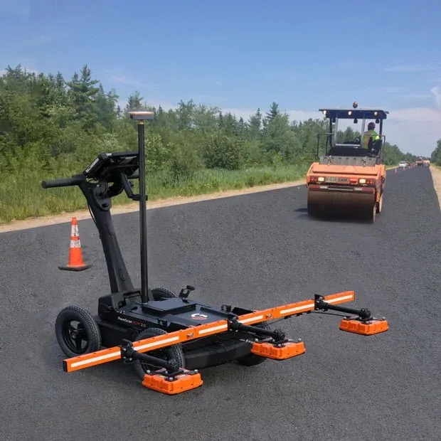
The complete PaveScan RDM 2.0 system includes a rugged deployment cart and an integrated concentrator box that accommodates up to three sensors. It includes housing for cable management and hot-swappable, dual batteries.

The new sensor design was built specifically for the extremes of the asphalt paving environment and features a green laser to aid location accuracy. Also available is a system upgrade kit to expand to three sensors for better pavement coverage.

Additional GPS options and mounting pole provide high precision location information and work seamlessly with the PaveScan interface.

For more information on companies in this article

Related Content

  • Leica’s GMX901plus GNSS receiver
    May 13, 2014
    The Leica GMX901plus is said by the Swiss firm to be an “affordable and rugged” GNSS receiver that delivers precise and reliable data about movements of sensitive structures such as mine walls, rock slopes, dams, and buildings. For time-critical applications that require high rate data and a higher accuracy the GMX901plus can be smoothly upgraded to a powerful L1/L2 GPS/GLONASS receiver with an update rate of 5Hz.
  • New non-destructive testing technologies for roads and bridges
    July 11, 2018
    Two new technologies for non-destructive testing offer key benefits, one suiting road surfaces, the other suiting concrete structures - Kristina Smith reports Dynatest has developed a new way to measure and record the state of pavements, using a machine that travels at the same speed as traffic. The Rapid Pavement Tester (Raptor) has been seven years in the making and offers road owners the chance to have comprehensive surveys without the need to disrupt traffic. “People have been wanting to do this for
  • AGD’s 318 Traffic Control Radar rises above the fray
    September 28, 2018
    England’s Staffordshire County has replaced speed detection loops at a busy junction with the AGD above-ground 318 Traffic Control Radar. The council, as with many local authorities, is avoiding in-ground detection wherever possible as a smart solution to wear-prone loops and magnetometers. “Because the road surface was in such poor condition where the [below-ground] loops would have been installed, the AGD 318 radar gave us an ideal, non-intrusive solution for detection,” said Martin Fenlon, principal si
  • Autoscope Duo unveiled
    March 16, 2012
    Econolite and Image Sensing Systems have unveiled Autoscope Duo, a first in a new generation of hybrid sensor technologies. The device converges the robust capabilities of radar and video and uses intelligent decision logic to monitor the current operating conditions and to combine the best of radar with the best of video data, continuously, lane-by-lane and second-by-second.