Radar Portal Systems (RPS) has spent a lot of time developing its sophisticated pavement top-surface photometric imaging system so it can cater specifically for the aviation market. This has now been specially developed for use on aircraft runways and taxiways The system was recently used at Brisbane Airport to survey runway and runway shoulders, collecting photometric top-surface data at a 4m width at speeds of up to 100km/h. This dataset allows the firm to display meshing data of the runway surface showin
The system was recently used at Brisbane Airport to survey runway and runway shoulders, collecting photometric top-surface data at a 4m width at speeds of up to 100km/h.
This dataset allows the firm to display meshing data of the runway surface showing: true mesh profile, mesh profile against the design, and mesh profile rutting minus the Cross-fall of each profile. For runways, manual inspections remain a required process. But machine-based data collection allows both a more rapid and more efficient assessment and is especially useful on busy runways, as well as providing a quantitative snapshot in time of the runway state. The result provides both an initial assessment of the runway state and definitive measurements that allow the detection of runway change over time. The firm’s sophisticated RoadScout technology can be applied not only to road pavements, but also runways and taxiways. For use on a runway, a GPS-based guidance system is used to ensure accurate positional collection of multiple passes down a runway. The high precision, photometric-based surface imaging system allows accurate mapping of cracks, even on grooved surfaces. These photometric images can also be stitched together to produce a high resolution (1mm pixel size) map of the runway surface, showing both surface albedo and shape.
The laser data is stitched during post-processing to form a precise 3D mesh of the surface. Due to the use of the high precision IMU technology, the system is able to move beyond the accuracy of the reference station-corrected GPS system, allowing very accurate local topography measures.
This allows the production of measures such as long length rutting profiles (up to 15m in length), the calculation of Boeing roughness and groove closure. In addition, if a degraded area is detected using the surface imaging technology, ground penetrating radar (GPR) can be used to further determine the cause of this issue, by detecting the layer depths and possible areas of moisture ingress into the pavement structure. According to RPS, there is significant interest across the aviation sector in the implementation of this new technology and its benefits for the industry.
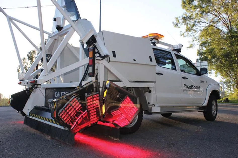
Core to the RoadScout technology is a generic hardware and software platform, which allows integration of the various imaging and GPR elements into a single vehicle. The package includes laser scanning, environmental cameras, photometric imaging systems, positioning systems and GPR imaging trailers. The frame is mounted to the back of a dual cab pickup, and a roof rack assembly for environmental cameras. The rear seats of the pickup are removed to house the computer and control electronics.
The data collection software is a flexible code base that allows efficient collection of data from multiple data sources, including display, processing and storage. The primary software is a multithreaded, 64-bit application, allowing large buffers to be used, which enables multiple systems to reliably operate off a single computer. The code is also designed to synchronise between multiple computers if further computing resources are required. Through the use of common streams and data saving methods, adding a new device to the system becomes easy, as only the interface to the new device needs to be written.
The patented RoadScout NM-GPR system can determine 46 profiles across a 2.5m width, enabling full 3D imaging of the road subsurface at 100km/h and to a depth of 2m. According to the company, this system offers a wider and deeper scan of the surface than other packages and can operate reliably in difficult road conditions. In addition, this system also performs common midpoint (CMP) dielectric compensation at the same time as data collection, allowing calibration of subsurface layer depths and estimation of moisture within pavement layers. The firm claims that the package sets a high standard for high-speed GPR worldwide, with a massive opportunity for the technology to be utilised for roads, bridges and other infrastructure applications.