
Soil compaction efficiency boost from Trimble

Trimble claims that its new Earthworks Grade Control Platform version 2.4 soil compactor package offers a major gain in working efficiency
August 24, 2021 Read time: 2 mins
Trimble is now offering a sophisticated Earthworks system for use in soil compaction

This software is a GNSS-based, 3D compaction control solution that makes operations more accurate, faster and easier. The package shares the same benefits as other Trimble Earthworks software tools already available for excavators, dozers and motor graders, which deliver improved productivity.

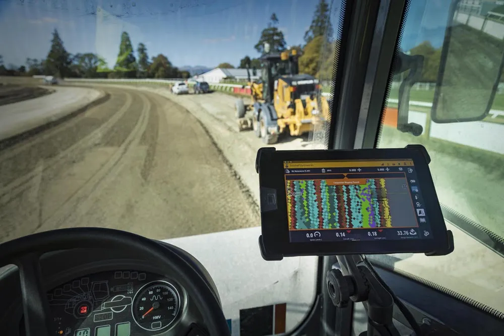
Trimble Earthworks for soil compactors enables contractors to control the compaction process accurately, reducing the risk of unnecessary passes that can result in over compaction. The platform makes the process more efficient, with a higher level of accuracy and less rework. As this package shares the same platform as other tools from the firm, contractors can benefit from shorter training times, reduced downtime and increased remote operator support in the field. In addition, users can benefit from ongoing platform developments as these become available.

Improvements in material/surface lifts and layer management allow for accurate data and convenient data management. Office-to-field connectivity allows efficient communication and data transfer across the project. Contractors have ready access to productivity data collected from the machine allowing comparisons between work previously completed and work just carried out.

Trimble Earthworks for soil compactors features software licensing options at different pricing levels for budget conscious contractors. New infield design licenses for operators or 3D model-only licenses for increased functionality in the office make it possible for contractors to only pay for the features that they need. 

For more information on companies in this article

Related Content

  • Advanced soil compaction technology coming to market
    March 17, 2016
    Several major manufacturers are introducing new technology for the soil compaction market - Mike Woof writes With the bauma 2016 exhibition drawing near, several major manufacturers are looking to expand their respective ranges of soil compactors, as well as to introduce innovative new technologies to the sector. Ammann is offering new models in the shape of its ARS 200 and ARS 220, both of which are Tier 4 Final/Stage IV compliant. These 20tonne and 22tonne class machines feature newly designed cab
  • New grade control system improves road surface
    July 16, 2012
    Trimble is offering a new version of its Trimble GCS900 grade control system designed for use with milling machines. The new package allows contractors using planers for road repairs to achieve material savings and increased road smoothness during the ensuing paving operation. By controlling the cutting depth of a milling machine accurately, a contractor is less likely to make an overcut in the areas being repaired and as a result, is less likely to require additional asphalt or concrete when paving the new
  • Cultivate better on-site safety awareness by leveraging technology with Leica Geosystems
    August 10, 2023
    When a vital fiber-optic cable was cut during construction work in Germany, the impact was huge. There were telecom disruptions affecting the greater Frankfurt area, all departures and landings at Frankfurt Airport were suspended, and Lufthansa’s global IT system crashed. Leica Geosystems says it is vital to put in place “strategies to protect people, equipment, and assets… and to emphasise the crucial role digital solutions play in ensuring safety.”
  • Road construction software innovations
    February 13, 2012
    A range of key software innovations are now available for road construction applications from various suppliers - Adrian Greeman writes. Two significant and highly economic alternatives are now available to the major CAD providers both from Belgium and both offering interesting features. First is Pythagoras, which describes itself as a modern CAD program specially designed for topographical applications which include land surveying, road design and city planning.