The novel EZ Dig Pro system offers real-time depth control for excavators and backhoe loaders. This package is said to provide precise grade control for digging a fixed depth or a slope and it boosts safety as there is no need for anyone going into the excavation to check depth. Applications include use in trenching and drainage ditches along roadways, as well as footings and foundation depths and cut-and-cover applications for a fixed depth for utilities.
The novel EZ Dig Pro system offers real-time depth control for excavators and backhoe loaders. This package is said to provide precise grade control for digging a fixed depth or a slope and it boosts safety as there is no need for anyone going into the excavation to check depth. Applications include use in trenching and drainage ditches along roadways, as well as footings and foundation depths and cut-and-cover applications for a fixed depth for utilities.
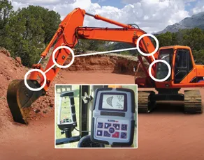
Sensors mounted on the excavator measure the movement and angle of the bucket, boom, and dipper stick to give continuous depth control indication on the in-cab display. The operator does not need to stop digging to place the bucket and dipper stick in the same position to take an accurate reading and the system can help make substantial reductions in over cutting and reinstatement.
The system can be installed and calibrated by any operator in 45 minutes or less using its patent-pending software. No welding is required, as the sensors mount to the excavator with strong magnets, while the unit can be calibrated to several machines as it retains the data when moved between equipment. One of the three sensors includes a laser receiver, to eliminate resetting the elevation reference when the excavator is moved.
The sensors have solar panels to maintain their charge, and the system uses wireless RF communication between the sensors and in-cab displays, eliminating external cables.