
Weathering WIM installation

Kistler says that its new smartphone App has made it easier to properly install sensors for its weigh-in-motion systems.
March 8, 2021 Read time: 2 mins
Thanks to an app from sensor manufacturer Kistler, documentation is easier and more practical

Sensors in the road surface record the weight of vehicles while driving – without impairing the flow of traffic. But installation has involved a considerable inconvenience - having to document the process on paper forms, notes Kistler, a global Swiss company that focuses on measurement technologies for dynamic pressure, force, torque and acceleration.

Thanks to its new app, documentation is not only easier and more practical, but also comes with the extra advantage of real-time support from WIM specialists.

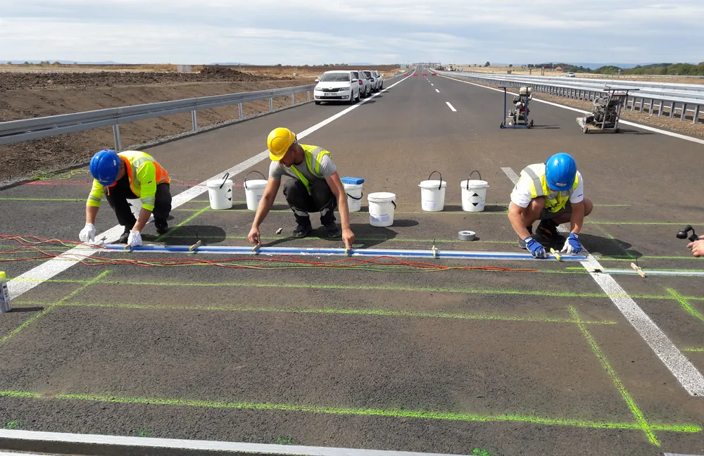
Sensor installation usually takes only a few hours. However, factors such as weather on the day of installation or road conditions, can significantly affect the durability of measurement equipment and sensors. These factors also influence the quality of measurements.

For instance, when installed in a wet slot, the adhesion of the grout will be weak, leading to bad fixation of the sensors in the road. To ensure the sensors’ longevity and accuracy and to grant the customer full warranty, the installation process has to be documented carefully. Usually, this means filling out pages-long paper forms at the installation site. But this is rarely very practicable, especially during a night-time installation or when standing in the middle of a road in windy weather. The forms are often lost or illegible - or technicians simply forget about them.

Thanks to the new WIM app from Kistler, documentation is now more practical and less time-consuming. Technicians easily enter information using a smartphone. The site is located via GPS and a photo of the installation plan functions as the basic site layout. Meanwhile, close-up photos of the pavement suffice as documentation of the road conditions. The sensor is identified by scanning its bar code.

The app is clearly structured and guides users through the installation steps. Green symbols indicate that the form is completed. The data is then submitted to Kistler and assessed by a specialist for immediate feedback and support. The onsite technician receives a PDF report for each WIM site and is notified that Kistler has approved the installation. The app can be used by any registered technician and is available for iOS and Android.


For more information on companies in this article

Related Content

  • Allu app provides attachment data
    April 27, 2018
    Finnish attachment maker Allu has tapped into iOS and Android platforms with the development of an app. By entering the serial number of the Allu Transformer or Processor attachment, the operator can access a description of the implements, the ability to match the base machine to the attachment and access operational and installation guides.
  • Roadmarking requirements can boost highway safety for road users
    April 11, 2013
    Road markings are an essential component of a modern infrastructure and an essential contributor to driver comfort and road safety. The COST 331 study, which ran from 1996 to 1999, mainly focused on dry night conditions and indicated that the increased luminance of road markings, results in a better delineation of the road and offers more reaction time for drivers. On average a slight increase in speed was noted, but the increased visibility was mainly converted into more reaction time. IMPROVER, which ran
  • Zehntner ZRM 6013
    July 2, 2012
    According to Zehntner, the Swiss manufacturer of testing instruments, despite some initial costs, quality control quickly pays for itself, especially with budgets getting tighter. Its solutions include three models which can be used according to requirements. For example, its ZVR 6000 is primarily designed for the fast comparative assessment of the night visibility (RL) of road markings. However, says Zehntner, the ZVR 6000 can accomplish much more including the inspection of dry or wet road markings under
  • Leica’s GMX901plus GNSS receiver
    May 13, 2014
    The Leica GMX901plus is said by the Swiss firm to be an “affordable and rugged” GNSS receiver that delivers precise and reliable data about movements of sensitive structures such as mine walls, rock slopes, dams, and buildings. For time-critical applications that require high rate data and a higher accuracy the GMX901plus can be smoothly upgraded to a powerful L1/L2 GPS/GLONASS receiver with an update rate of 5Hz.