
The weathercast from TempCast

TempCast, from Vaisala, is a wireless, pole-mounted sensor that measures air temperature, humidity and pavement surface temperature - without touching the pavement.
By David Arminas August 9, 2023 Read time: 1 min
TempCast is a self-powered, wireless NB-IoT unit and the latest IoT-based sensor from Vaisala (image courtesy of Vaisala)

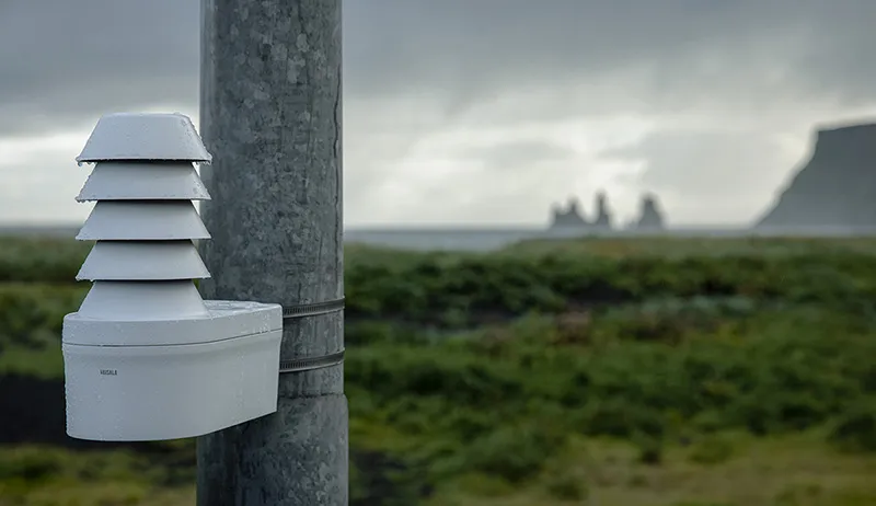
The combination of Vaisala’s TempCast and Wx Horizon solutions is an easy and affordable way to get accurate road weather measurements from challenging locations.

TempCast is a wireless, pole-mounted sensor that measures air temperature, humidity and pavement surface temperature without ever touching the pavement. With built-in connectivity and power, TempCast can be installed almost anywhere, turning an ordinary road into a smart road. It brings additional observational value from locations between existing road weather stations, that were previously hard to measure. It can also be used to build entirely new networks that were not feasible before.

TempCast – a self-powered, wireless NB-IoT unit - is the latest IoT-based sensor in Vaisala’s offerings and comes with a three-year battery lifetime. Meanwhile, Vaisala GroundCast, an in-ground IoT-based sensor that measures pavement temperature from different depths, as well as the road surface state, was introduced last year.

Both TempCast and GroundCast connect to Wx Horizon, Vaisala’s subscription-based weather hazard impact portal that delivers visualisations, alerts and insights on current and future road conditions.

Vaisala says that its weather and environmental technologies are routinely used to develop creative, new applications in the areas of traffic management, winter maintenance, advanced automotive applications and beyond.

For more information on companies in this article

Related Content

  • Improved excavators from major firms
    January 31, 2022
    New excavators are being offered that offer improved performance over previous generation machines
  • ERIC 2016: What shape the ‘Smart Road’?
    February 7, 2017
    Optimism about the future of highways worldwide abounded at the inaugural European Road Infrastructure Conference (ERIC) in Leeds, UK Around 500 delegates passed through the varied sessions during the three-day event at the Royal Armouries Museum in the northern English city of Leeds. They came away with many visions of what a motorway and road could look like. But what speakers at the event - co-organised by the Brussels-based European Union Road Federation (ERF) and the UK’s Road Safety Markings Ass
  • Positioning tools continue to improve
    July 16, 2012
    Topcon says that its new IP-S2 package combines GNNS positioning capabilities with inertial sensors, while the firm also has a solution for customers wanting to mix and match receiver components. The IP-S2 is a vehicle-mounted, mobile 3D tool that offers precision mapping and surveying capabilities. The package collects data using 3D laser scanners, LIDAR, and/or cameras, and this is then integrated, time-stamped and geo-referenced. The customer can use this assembled data to combine LIDAR point cloud and d
  • Innovations in plant development
    September 19, 2024
    Several of the major manufacturers are offering key innovations for the asphalt plant segment – Mike Woof writes