Smarter transport solutions from TomTom

TomTom is introducing two novel products that help deliver smart traffic solutions, RoadDNA and its HAD map. The Road DNA will help make automated driving a reality, according to the firm. Designed with vehicle data storage and processing limitations in mind, RoadDNA delivers highly accurate location information that can easily be integrated into the onboard system of a vehicle. This allows a vehicle to continuously know exactly where it is located on the road. It offers highly accurate vehicle localisa
January 4, 2016 Read time: 2 mins
The TomTom technology provides a stepping stone for autonomous vehicle mdevelopment
3972 TomTom is introducing two novel products that help deliver smart traffic solutions, RoadDNA and its HAD map. The Road DNA will help make automated driving a reality, according to the firm. Designed with vehicle data storage and processing limitations in mind, RoadDNA delivers highly accurate location information that can easily be integrated into the onboard system of a vehicle.

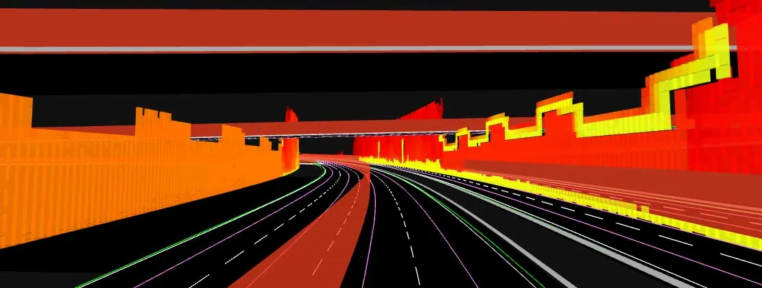
This allows a vehicle to continuously know exactly where it is located on the road. It offers highly accurate vehicle localisation content in an efficient and cost-effective way. By matching RoadDNA data with vehicle sensor data in real-time, a vehicle knows its location on the road and even while travelling at high speeds or when changes occur to the roadside. But by converting a 3D point cloud of roadside patterns into a compressed, 2D view of the roadway, RoadDNA delivers a solution that needs little storage space and requires conventional processing requirements, without losing detail.

TomTom RoadDNA, combined with the TomTom HAD Map, delivers real-time information about a vehicle’s precise location on a map whilst coping with changes in the environment. The firm is also offering its HAD Map for Germany. This complete map of Germany covers the entire Autobahn network and provides a 3D lane map for 24,000km of roads.

The TomTom HAD Map for Germany provides accurate representation of 3D geometries of lane centrelines, lane dividers, road borders, and guard rails, as well as highlighting lane-dependent speed limits and lane divider marking types. In addition to enabling future self-driving cars to see beyond their sensors, the TomTom HAD map can also be used for advanced driving applications like improved versions of eco-adaptive cruise control (ACC), lane level guidance, and predictive powertrain control.

For more information on companies in this article

Related Content

  • Traffic management drives sustainability
    June 18, 2012
    New initiatives could boost transport sustainability – David Crawford writes. New roles are opening up for urban traffic management systems in helping city authorities to meet increasingly stringent governmental and supra-governmental air quality standards. European local authorities are typically tasked with both traffic management and pollution monitoring within their areas, making them well placed to draw on the latter to mitigate the impacts of the former.
  • Lowering construction machine exhaust emissions
    November 6, 2017
    The alternatives to diesel fuel as a power source continue to grow as firms move to cut emissions - Mike Woof writes. Only the most myopic could have failed to notice that times are changing in terms of engine technology. In the on-highway automotive sector as well as for the off-highway construction machine segment, manufacturers are looking to lower tailpipe emissions. Similar technologies have been employed in both on-highway and off-highway sectors, although those solutions have been adapted to better
  • Connected vehicles: implications for road networks and mobility
    May 15, 2019
    Mobility services are expected to undergo spectacular changes within the next two decades with the introduction and widespread use of connected and autonomous vehicle (CAV) technology. However, the transition phase from human driving to self-driving will be gradual, requiring incremental interventions on the physical and digital road network to allow it to cope with mixed vehicular traffic. Cities such as Dubai have embraced the challenge by setting a target to reach 25% driverless trips by 2030 as part o
  • GPS machine control systems reduce survey time
    February 14, 2012
    Innovative uses are being made of GPS technology, Mike Woof reports. US firms Creighton Manning Engineering and Delaney Construction have made a novel use of GPS technology in a project for the Route 85 Slingerlands bypass extension in the US.