Smarter transport solutions from TomTom

TomTom is introducing two novel products that help deliver smart traffic solutions, RoadDNA and its HAD map. The Road DNA will help make automated driving a reality, according to the firm. Designed with vehicle data storage and processing limitations in mind, RoadDNA delivers highly accurate location information that can easily be integrated into the onboard system of a vehicle. This allows a vehicle to continuously know exactly where it is located on the road. It offers highly accurate vehicle localisa
January 4, 2016 Read time: 2 mins
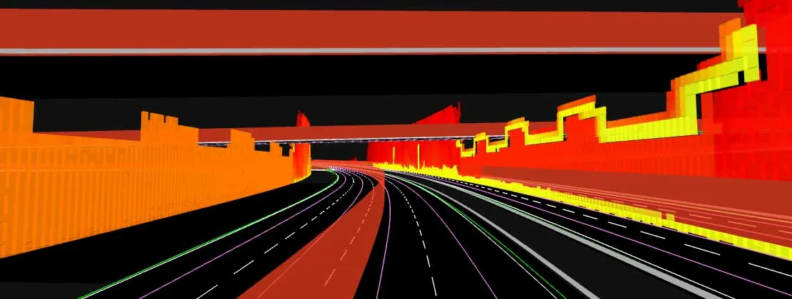
The TomTom technology provides a stepping stone for autonomous vehicle mdevelopment
3972 TomTom is introducing two novel products that help deliver smart traffic solutions, RoadDNA and its HAD map. The Road DNA will help make automated driving a reality, according to the firm. Designed with vehicle data storage and processing limitations in mind, RoadDNA delivers highly accurate location information that can easily be integrated into the onboard system of a vehicle.

This allows a vehicle to continuously know exactly where it is located on the road. It offers highly accurate vehicle localisation content in an efficient and cost-effective way. By matching RoadDNA data with vehicle sensor data in real-time, a vehicle knows its location on the road and even while travelling at high speeds or when changes occur to the roadside. But by converting a 3D point cloud of roadside patterns into a compressed, 2D view of the roadway, RoadDNA delivers a solution that needs little storage space and requires conventional processing requirements, without losing detail.

TomTom RoadDNA, combined with the TomTom HAD Map, delivers real-time information about a vehicle’s precise location on a map whilst coping with changes in the environment. The firm is also offering its HAD Map for Germany. This complete map of Germany covers the entire Autobahn network and provides a 3D lane map for 24,000km of roads.

The TomTom HAD Map for Germany provides accurate representation of 3D geometries of lane centrelines, lane dividers, road borders, and guard rails, as well as highlighting lane-dependent speed limits and lane divider marking types. In addition to enabling future self-driving cars to see beyond their sensors, the TomTom HAD map can also be used for advanced driving applications like improved versions of eco-adaptive cruise control (ACC), lane level guidance, and predictive powertrain control.

For more information on companies in this article

Related Content

  • SICK launches 3D TIC502 LiDAR sensor system for traffic management
    May 18, 2018
    Sick says that its latest TIC502 twin LiDAR sensor system has high all-weather capability between -40OC and +60OC. The TIC502 incorporates vehicle speed detection with 3D profiling and counting of fast-lane, free flowing and static traffic to facilitate toll charge assessment. It can also be integrated with additional 2D LiDAR sensors to count axles for complete traffic profiling and assessment in a single system, according to the company that was set up in 1946 by optical engineer Erwin Sick in Waldkir
  • GPS guidance delivers accurate machine control
    July 12, 2012
    GPS systems for machine control can make massive reductions in operating costs for contractors. Using GPS systems for machine control can make massive reductions in operating costs for contractors and the pace of technology improvements from manufacturers has been rapid. This market segment is dominated by Leica Geosystems, Trimble and Topcon, all of which introduced an array of new products earlier this year. Topcon's dozer control system first seen in public at the Intermat show in Paris, offers notable c
  • Free modeling: Improving efficiency in construction- site management
    July 24, 2025
    Liebherr’s innovative Free Modeling technology enables road-construction operators to create and modify simple 3D site models directly from their machinery, enhancing real-time decision-making.
  • Smart road test facility in Virginia
    July 28, 2015
    A test stretch of road in the US is playing a valuable role in developing technology and boosting traffic safety -*Tom Gibson writes Located a short distance from the Virginia Tech campus in the mountains of rural southwest Virginia in the mid-Atlantic region of United States, the Virginia Smart Road looks like a conventional road. But venturing to either end of the 3.5km-long thoroughfare reveals that it actually goes nowhere, at least for now. The result of a plan conceived back in the 1980s, the Vi